

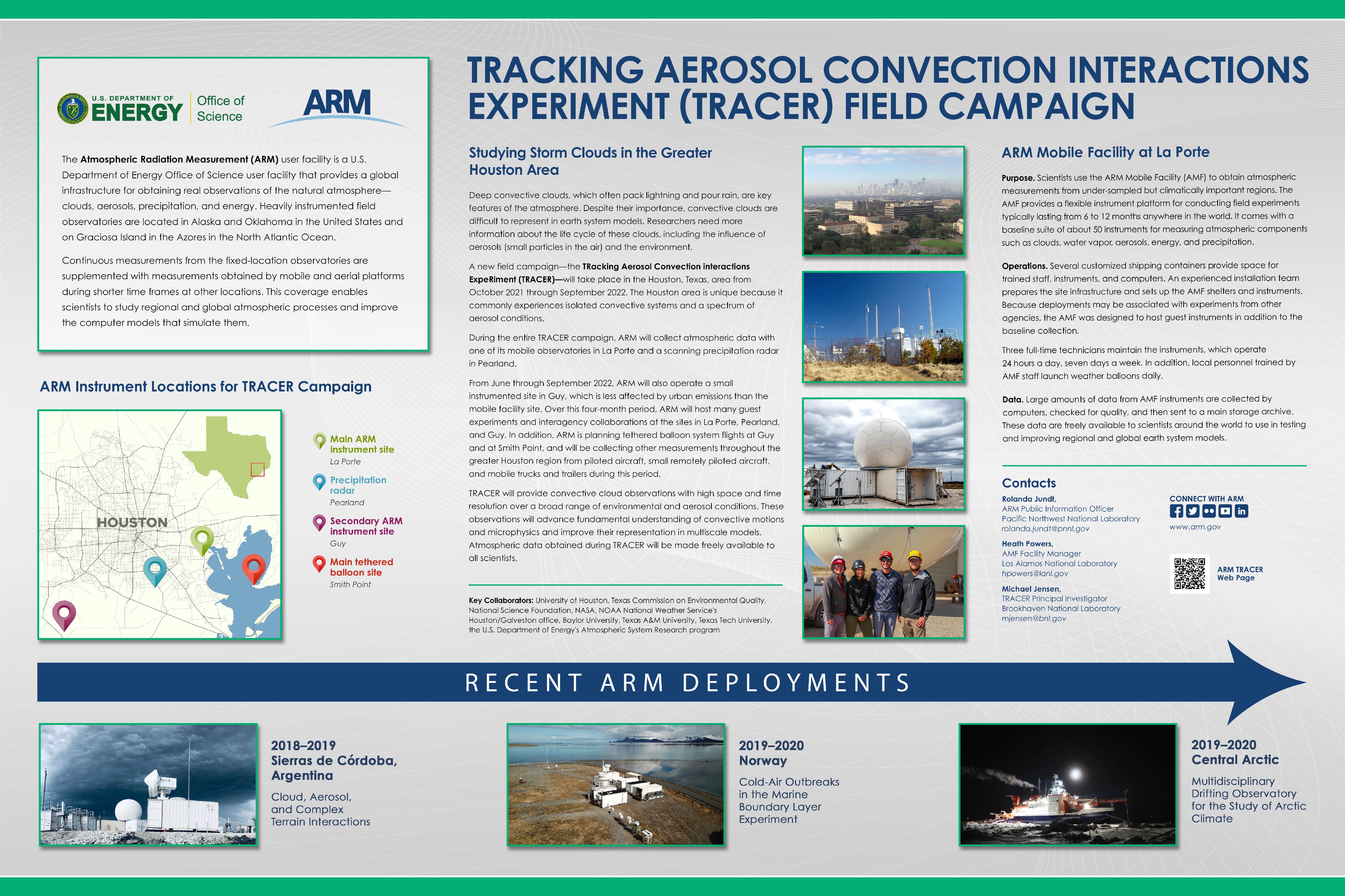
TRACER
Tracking Aerosol Convection Interactions Experiment (TRACER)
1 October 2021 - 30 September 2022
Lead Scientist: Michael Jensen
Observatory: AMF (ARM Mobile Facility 1) - HOU
During the TRacking Aerosol Convection interactions ExpeRiment (TRACER), scientists will use the first ARM Mobile Facility (AMF1), the second-generation C-Band Scanning ARM Precipitation Radar (CSAPR2), and a small satellite (ancillary) site with radiosonde and aerosol measurements to learn more about cloud and aerosol interactions in the deep convection over the Houston, Texas, area.
The Houston region offers a unique environment where isolated convective systems are common and experience a spectrum of polluted aerosol conditions from urban and industrial areas. In addition, surrounding areas also show significantly lower background aerosol concentrations.
The TRACER campaign has been postponed from its originally planned dates due to COVID-19 risks associated with the earlier dates. The revised dates for TRACER are October 1, 2021, to September 30, 2022.
TRACER also will include a four-month intensive operational period (IOP). A climatological analysis of radar observations from the Houston/Galveston-area NEXRAD (KHGX) shows that convective initiation occurs in this area on 40 to 55 percent of the days each month of the year. The total number of convective events is strongly peaked during the months of June through September. To capture these events, the TRACER IOP will run from June 1 to September 30, 2022.
With this single IOP during the convective season of 2022, this effectively postpones the original TRACER IOP by one year.
The TRACER campaign consists of three primary sites operated by ARM:
- the AMF1 main site (M1) in La Porte, Texas, an area that experiences significant polluted conditions, 29° 40' 12" N, 95° 3' 32.4" W (29.670000, -95.059000)
- the ancillary site (S3) to the southwest of downtown Houston in a rural region with less pollution, 29° 19′ 40.8″ N, 95° 44′ 27.6″ W (29.328000, -95.741000)
- the CSAPR2 site (S2) located approximately midway between the AMF1 and ancillary sites, 29° 31′ 55.2″ N, 95° 17′ 2.4″ W (29.532000, -95.284000)
The main and CSAPR2 sites will operate during the entire TRACER campaign, while the ancillary site will only operate during the IOP. Operation dates for the three primary sites are as follows:
- Main (M1): October 1, 2021, to September 30, 2022
- CSAPR2 (S2): October 1, 2021, to September 30, 2022
- Ancillary (S3): June 1 to September 30, 2022.
During the IOP, ARM will host many guest experiments and interagency collaborations at the TRACER sites. All three primary sites will host guest experiments, but most will be at the main site.
In addition, during the 2022 IOP, ARM is planning tethered balloon system (TBS) flights at the ancillary site.
Campaign Links
- Field Campaign Report
- Science Plan
- NASA TRACER-AQ Page
- TRACER Blogs by Co-Investigator Scott Collis
- Campaign Poster
- Images
- Campaign Dashboard
- Backgrounder
- Media
- ARM News
- Baseline Instruments
Related Publications
View all- Jensen et al. "Studying Aerosol, Clouds, and Air Quality in the Coastal Urban Environment of Southeastern Texas". 2025. 10.1175/BAMS-D-23-0331.1.
Related Campaigns
Co-Investigators
Sarah Brooks
Don Collins
Scott Collis
Eric Defer
Jiwen Fan
James Flynn
Ann Fridlind
Scott Giangrande
Robert Griffin
Jiaxi Hu
Robert Jackson
Pavlos Kollias
Chongai Kuang
Matthew Kumjian
Toshihisa Matsui
Greg McFarquhar
Chris Nowotarski
Richard Orville
Mariko Oue
Anita Rapp
Daniel Rosenfeld
Alexander Ryzhkov
Rebecca Sheesley
Jeffrey Snyder
Philip Stier
Sascha Usenko
Adam Varble
Yuxuan Wang
Guang Zhang
Renyi Zhang
Marcus van Lier-Walqui
Sue van den Heever
Timeline
Campaign Data Sets
| IOP Participant | Data Source Name | Final Data |
|---|---|---|
| Gabrielle Whitson | Distributed Temperature Sensing | Order Data |
| Gabrielle Whitson | Distributed Temperature Sensing, airborne | Order Data |
HOU Data Sources
| Name | Full Name | Browse Data |
|---|---|---|
ACSM
|
Aerosol Chemical Speciation Monitor | Browse Data |
ACSMCDCE
|
ACSM, corrected for composition-dependent collection efficiency | Browse Data |
AERI
|
Atmospheric Emitted Radiance Interferometer | Browse Data |
AERINF
|
AERI Noise Filtered | Browse Data |
AETH
|
Aethalometer | Browse Data |
AOD
|
Aerosol Optical Depth, derived from atmospheric extinction of solar irradiance | Browse Data |
AODBE
|
Aerosol Optical Depth Best Estimate | Browse Data |
AOD-MFRSR
|
Aerosol Optical Depth (AOD) derived from MFRSR measurements | Browse Data |
AOP
|
Aerosol Optical Properties | Browse Data |
AOS
|
Aerosol Observing System | Browse Data |
AOSMET
|
Meteorological Measurements associated with the Aerosol Observing System | Browse Data |
APS
|
Aerodynamic Particle Sizer | Browse Data |
ARMBE
|
ARM Best Estimate Data Products | Browse Data |
ARMTRAJ-AIR
|
Airmass trajectories to support studies using ARM Aerial Facility (AAF) data. | Browse Data |
CAMSITE
|
camera that monitors a site area | Browse Data |
CCN
|
Cloud Condensation Nuclei Particle Counter | Browse Data |
CEIL
|
Ceilometer | Browse Data |
CEILPBLHT
|
Boundary-layer height data with CEIL | Browse Data |
CLDTYPE
|
Cloud Type Classification | Browse Data |
CO-ANALYZER
|
Carbon Monoxide Analyzer | Browse Data |
CPC
|
Condensation Particle Counter | Browse Data |
CPC-AIR
|
Condensation particle counter aboard aircraft | Browse Data |
CSAPR
|
C-Band Scanning ARM Precipitation Radar | Browse Data |
CSAPR2-CMAC
|
C-SAPR2 Corrected Moments in Antenna Coordinates | Browse Data |
CSPHOT
|
Sunphotometer | Browse Data |
DL
|
Doppler Lidar | Browse Data |
DLPROF-WIND
|
Doppler Lidar Wind | Browse Data |
DLPROF-WSTATS
|
Doppler Lidar Vertical Velocity Statistics | Browse Data |
DTS-AIR
|
Distributed Temperature Sensing, airborne | Browse Data |
ECMWFDIAG
|
European Centre for Medium Range Weather Forecasts Diagnostic Analyses | Browse Data |
ECOR
|
Eddy Correlation Flux Measurement System | Browse Data |
GENSTATE
|
Generator State | Browse Data |
GNDRAD
|
Ground Radiometers on Stand for Upwelling Radiation | Browse Data |
HTDMA
|
Humidified Tandem Differential Mobility Analyzer | Browse Data |
INS
|
Ice Nucleation Spectrometer for INP measurement | Browse Data |
INTERPSONDE
|
Interpolated Sonde | Browse Data |
IRT
|
Infrared Thermometer | Browse Data |
KASACR
|
Ka-Band Scanning ARM Cloud Radar | Browse Data |
KASACRGRIDPPI
|
Ka-Band Scanning ARM Cloud Radar PPI scan, Cartesian Cloud Cover Grid VAP | Browse Data |
KASACRGRIDRHI
|
Ka-Band Scanning ARM Cloud Radar RHI scan, Cartesian Cloud Cover Grid VAP | Browse Data |
KAZR
|
Ka ARM Zenith Radar | Browse Data |
KAZRARSCL
|
Active Remote Sensing of CLouds (ARSCL) product using Ka-band ARM Zenith Radars | Browse Data |
KAZRCFRCOR
|
Ka-Band ARM Zenith RADAR (KAZR) CF-Radial, Corrected VAP | Browse Data |
LDIS
|
Laser Disdrometer | Browse Data |
LDQUANTS
|
Laser Disdrometer Quantities | Browse Data |
MAWS
|
Automatic Weather Station | Browse Data |
MERGEDSMPSAPS
|
merged size distribution from SMPS and APS | Browse Data |
MERGEDSMPSAPSML
|
merged size distribution from SMPS and APS, Machine Learning | Browse Data |
MET
|
Surface Meteorological Instrumentation | Browse Data |
MFR
|
Multifilter Radiometer | Browse Data |
MFRSR
|
Multifilter Rotating Shadowband Radiometer | Browse Data |
MFRSRCLDOD
|
Cloud Optical Properties from MFRSR Using Min Algorithm | Browse Data |
MICROBASE
|
Continuous Baseline Microphysical Retrieval | Browse Data |
MONITORINST
|
sensors for providing instrument system monitoring | Browse Data |
MPL
|
Micropulse Lidar | Browse Data |
MPLCMASK
|
Cloud mask from Micropulse Lidar | Browse Data |
MPLCMASKML
|
Micropulse Lidar Cloud Mask Machine Learning VAP | Browse Data |
MWR
|
Microwave Radiometer | Browse Data |
MWR3C
|
Microwave Radiometer, 3 Channel | Browse Data |
MWRHF
|
Microwave Radiometer - High Frequency | Browse Data |
MWRRET
|
MWR Retrievals | Browse Data |
MWRRETV2
|
MWR Retrievals with MWRRET Version 2 | Browse Data |
NEPHELOMETER
|
Nephelometer | Browse Data |
NFOV
|
Narrow Field of View Zenith Radiometer | Browse Data |
OPC
|
Optical Particle Counter | Browse Data |
OZONE
|
Ozone Monitor | Browse Data |
PBLHT
|
Planetary Boundary Layer Height | Browse Data |
PCCP
|
Stereo Reconstructed Point Cloud of Cloud Points (PCCP) | Browse Data |
POPS-AIR
|
portable optical particle spectrometer aboard an airborne platform | Browse Data |
PRECIPBE
|
Precipitation Best Estimate | Browse Data |
PSAP
|
Particle Soot Absorption Photometer | Browse Data |
QCECOR
|
Quality Controlled Eddy Correlation Flux Measurement | Browse Data |
QCRAD
|
Data Quality Assessment for ARM Radiation Data | Browse Data |
RADFLUXANAL
|
Radiative Flux Analysis | Browse Data |
RWP
|
Radar Wind Profiler | Browse Data |
SASHE
|
Shortwave Array Spectroradiometer-Hemispheric | Browse Data |
SASHELANGLEY
|
Solar Array Spectrometer (Hemispheric) Langley Regressions | Browse Data |
SASZE
|
Shortwave Array Spectroradiometer-Zenith | Browse Data |
SEBS
|
Surface Energy Balance System | Browse Data |
SFCMETRADAQ-TCEQ
|
Meteorology, radiation, and air quality data from TCEQ air quality stations | Browse Data |
SKYRAD
|
Sky Radiometers on Stand for Downwelling Radiation | Browse Data |
SMPS
|
Scanning mobility particle sizer | Browse Data |
SO2
|
Sulfur Dioxide Monitor | Browse Data |
SONDE
|
Balloon-Borne Sounding System | Browse Data |
SONDEGRID
|
Gridded Sonde VAP Product | Browse Data |
SONDEPARAM
|
convective parameters derived from radiosonde data | Browse Data |
SP2
|
Single Particle Soot Photometer | Browse Data |
STEREOCAM
|
Stereo Cameras for Clouds | Browse Data |
SYNOPWEAREG
|
Synoptic Weather Regime Classification VAP products | Browse Data |
TBSGROUND
|
Tethered Balloon System Ground Measurement | Browse Data |
TBSMERGED
|
Tethered Balloon System (TBS) Merged Data Product | Browse Data |
TBSMET
|
Meteorological Instrumentation aboard TBS | Browse Data |
TROPOE
|
Tropospheric Optimal Estimation Retrieval | Browse Data |
TSI
|
Total Sky Imager | Browse Data |
UHSAS
|
Ultra-High Sensitivity Aerosol Spectrometer | Browse Data |
VARANAL
|
Constrained Variational Analysis | Browse Data |
VDIS
|
Video Disdrometer | Browse Data |
VDISQUANTS
|
Video Disdrometer VAP | Browse Data |
VISST
|
Minnis Cloud Products Using Visst Algorithm | Browse Data |
WB
|
Weighing Bucket Precipitation Gauge | Browse Data |
XSACR
|
X-Band Scanning ARM Cloud Radar | Browse Data |
XSACRGRIDPPI
|
X-Band Scanning ARM Cloud Radar PPI scan, Cartesian Cloud Cover VAP | Browse Data |
XSACRGRIDRHI
|
X-Band Scanning ARM Cloud Radar RHI scan, Cartesian Cloud Cover VAP | Browse Data |
Follow Us:


Keep up with the Atmospheric Observer
Updates on ARM news, events, and opportunities delivered to your inbox
ARM User Profile
ARM welcomes users from all institutions and nations. A free ARM user account is needed to access ARM data.


