

SAIL
Surface Atmosphere Integrated Field Laboratory (SAIL)
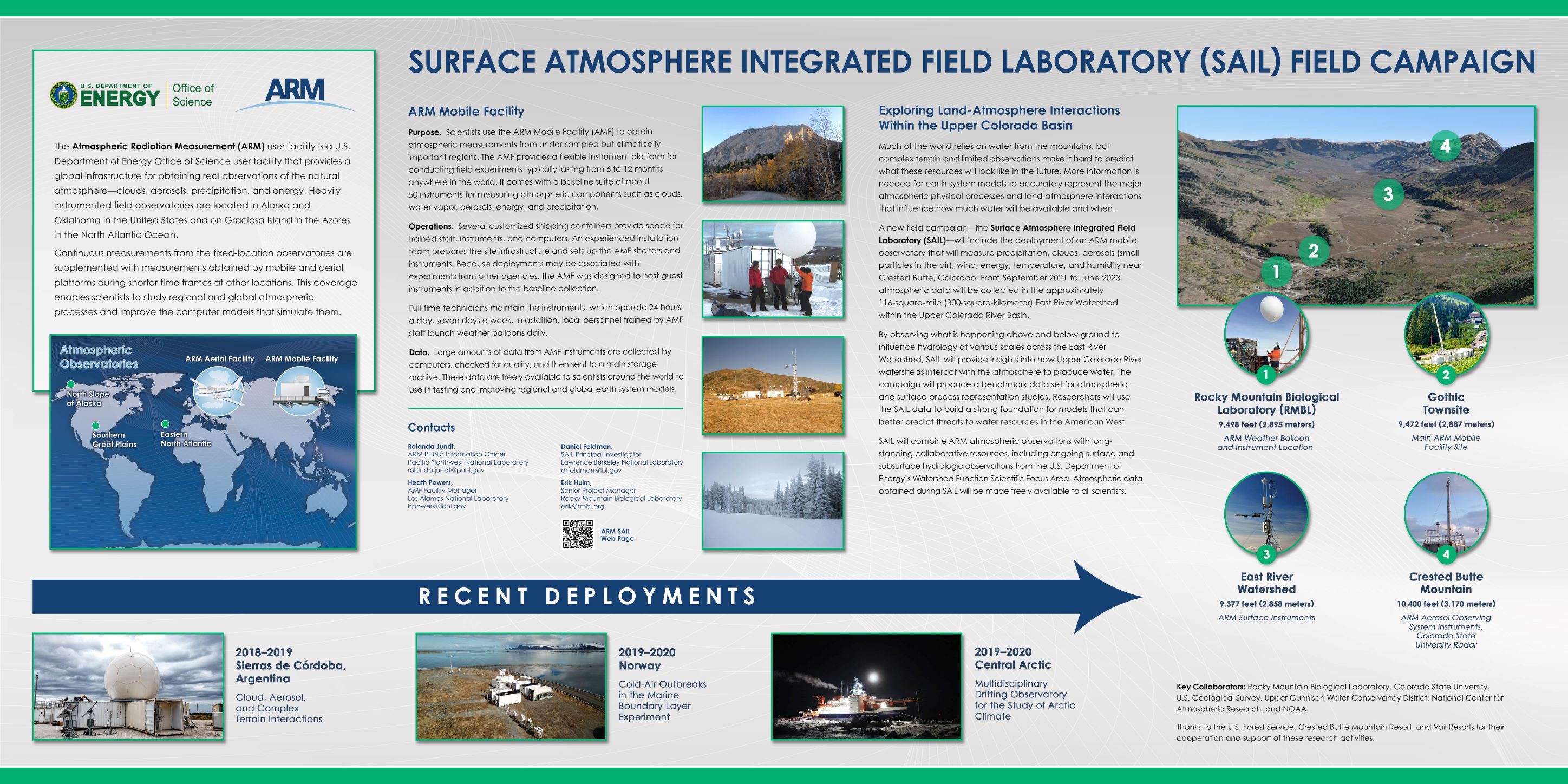
1 September 2021 - 15 June 2023
Lead Scientist: Daniel Feldman
Observatory: AMF (ARM Mobile Facility 2) - GUC
Mountains are the natural water towers of the world, but Earth System Models (ESMs) have persistently been unable to predict the timing and availability of water resources from mountains. The source(s) of model error are difficult to isolate in complex terrain with limited atmospheric or land-surface observations. Further complications arise from the gross scale mismatch between ESM grid box sizes and the relevant scales of mountainous hydrological processes. The mountain hydrometeorology community has repeatedly called for integrated atmospheric and surface observations of water and energy budgets in complex terrain that span these scales to establish benchmarks against which scale-dependent models can be developed. In response to these calls, the Surface Atmosphere Integrated Field Laboratory (SAIL) will make measurements using the second ARM Mobile Facility (AMF2) and a scanning X-band dual polarimetric radar near Crested Butte, Colorado. The campaign will focus on the East River Watershed, which is a 300-km2 mountainous watershed that is part of the Upper Colorado River Basin. SAIL will advance atmosphere-through-bedrock understanding of mountainous water cycles by collocating ARM atmospheric observations with long-standing collaborative resources including the ongoing surface and subsurface hydrologic observations from the Department of Energy’s Watershed Function Science Focus Area (SFA). The main science goal of the SAIL campaign is to develop a quantitative understanding of the atmosphere and land-atmosphere interaction processes, at their relevant scales, that impact mountain hydrology in the midlatitude continental interior of the United States.
To achieve this goal, the campaign will extend from September 2021 to June 2023, and will measure the seasonally varying controls on the surface energy and water budgets in high-altitude complex terrain in order to address four key science questions:
1. How do multi-scale dynamic and microphysical processes control the spatial and temporal distribution, phase, amount, and intensity of precipitation?
2. How strongly do aerosols affect the surface energy and water balance by altering clouds, precipitation, and surface albedo, and how do these impacts vary seasonally?
3. What are the contributions of snow sublimation, radiation, and turbulent fluxes of latent and sensible heat to the water and energy balance of the snowpack?
4. How do atmospheric and surface processes set the net radiative absorption that is known to drive the regional flow of water into the continental interior during the summer monsoon?
To answer these questions, SAIL measurements will pursue the following science objectives:
1. Characterize the spatial distribution of orographic and convective precipitation processes on diurnal to seasonal time scales and how those processes interact with large-scale circulation.
2. Quantify cold-season land-atmosphere interactions that alter snowpack mass balance through wind redistribution and sublimation and the spatial scaling of those processes.
3. Establish aerosol regimes, the processes controlling the life cycle of aerosols in those regimes, and quantify the impacts of aerosols in those regimes on the atmospheric and surface radiative budget.
4. Quantify the sensitivity of cloud phase and precipitation to cloud condensation nuclei (CCN) and ice-nucleating particle (INP) concentrations.
5. Quantify the seasonally varying surface energy balance, the land-surface and atmospheric factors controlling it, and the spatial variability in those factors.
By measuring the inputs to, outputs from, and processes within a heavily studied mountainous watershed, SAIL will produce a benchmark data set for atmospheric and surface process representation studies. Those studies, in turn, will be used to develop a robust foundation for advancing the sub-grid representation of these processes in ESMs.
SAIL is complemented by a concurrent NOAA-led campaign in the region: the Study of Precipitation, the Lower Atmosphere, and Surface for Hydrometeorology (SPLASH). The yearlong SPLASH campaign is designed to gain detailed insight into the physical processes that drive basin-scale weather and water availability in the Mountain West. SPLASH will run through summer 2022.
Campaign Links
- Field Campaign Report
- Science Plan
- Campaign Dashboard
- NOAA SPLASH Campaign Website
- Media
- SAIL Website
- Backgrounder
- Images
- Campaign Poster
- DOE Watershed Function SFA Website
- ARM News
- Baseline Instruments
Related Publications
View all- Wang et al. "Interpretable ensemble learning unveils main aerosol optical properties in predicting cloud condensation nuclei number concentration". 2025. 10.1038/s41612-025-01181-y.
Related Campaigns
- Cloud processing of aerosol during SAIL
- SAIL Aerosol Vertical Profiles
- CCN and INP variability in mountainous terrain
Co-Investigators
Allison Aiken
William Boos
V. Chandrasekar
William Collins
Scott Collis
Paul DeMott
Jiwen Fan
Alejandro Flores
David Gochis
Jerry Harrington
Matthew Kumjian
L. Ruby Leung
Travis OBrien
Mark Raleigh
Alan Rhoades
James N. Smith
Ryan Sullivan
Paul Ullrich
Adam Varble
Kenneth Williams
Timeline
Campaign Data Sets
| IOP Participant | Data Source Name | Final Data |
|---|---|---|
| Curtis Beutler | Manual Snowboard and Snowstakes | Order Data |
| Sergey Matrosov | Snowfall Rate Estimates using Ka-Band Radar Measurements | Order Data |
| Gabrielle Whitson | camera onboard a tethered balloon system (TBS) | Order Data |
| Zexuan Xu | Weather Research and Forecasting (WRF) Model Output | Order Data |
| Ruichen Zhou | Merged aerosol size distribution from SMPS and OPC | Order Data |
GUC Data Sources
| Name | Full Name | Browse Data |
|---|---|---|
ACSM
|
Aerosol Chemical Speciation Monitor | Browse Data |
ACSMCDCE
|
ACSM, corrected for composition-dependent collection efficiency | Browse Data |
AERI
|
Atmospheric Emitted Radiance Interferometer | Browse Data |
AERINF
|
AERI Noise Filtered | Browse Data |
AOD-MFRSR
|
Aerosol Optical Depth (AOD) derived from MFRSR measurements | Browse Data |
AOP
|
Aerosol Optical Properties | Browse Data |
AOS
|
Aerosol Observing System | Browse Data |
AOSMET
|
Meteorological Measurements associated with the Aerosol Observing System | Browse Data |
AREALAVEALB
|
Areal-Averaged Surface Albedo | Browse Data |
ARMBE
|
ARM Best Estimate Data Products | Browse Data |
ARMTRAJ-AIR
|
Airmass trajectories to support studies using ARM Aerial Facility (AAF) data. | Browse Data |
CAMINST
|
camera that monitors an instrument | Browse Data |
CAMSITE
|
camera that monitors a site area | Browse Data |
CCN
|
Cloud Condensation Nuclei Particle Counter | Browse Data |
CCNKAPPA
|
CCN Counter derived hygroscopicity parameter kappa | Browse Data |
CEIL
|
Ceilometer | Browse Data |
CEILPBLHT
|
Boundary-layer height data with CEIL | Browse Data |
CLDTYPE
|
Cloud Type Classification | Browse Data |
CO-ANALYZER
|
Carbon Monoxide Analyzer | Browse Data |
CPC
|
Condensation Particle Counter | Browse Data |
CPC-AIR
|
Condensation particle counter aboard aircraft | Browse Data |
CSPHOT
|
Sunphotometer | Browse Data |
DL
|
Doppler Lidar | Browse Data |
DLPROF-WIND
|
Doppler Lidar Wind | Browse Data |
DLPROF-WSTATS
|
Doppler Lidar Vertical Velocity Statistics | Browse Data |
ECMWFDIAG
|
European Centre for Medium Range Weather Forecasts Diagnostic Analyses | Browse Data |
ECOR
|
Eddy Correlation Flux Measurement System | Browse Data |
GENSTATE
|
Generator State | Browse Data |
GNDRAD
|
Ground Radiometers on Stand for Upwelling Radiation | Browse Data |
HSRL
|
High Spectral Resolution Lidar | Browse Data |
HTDMA
|
Humidified Tandem Differential Mobility Analyzer | Browse Data |
INS
|
Ice Nucleation Spectrometer for INP measurement | Browse Data |
INS-AIR
|
Ice Nucleation Spectrometer for INP measurements aboard aircraft | Browse Data |
INTERPSONDE
|
Interpolated Sonde | Browse Data |
IRT
|
Infrared Thermometer | Browse Data |
KAZR
|
Ka ARM Zenith Radar | Browse Data |
KAZRARSCL
|
Active Remote Sensing of CLouds (ARSCL) product using Ka-band ARM Zenith Radars | Browse Data |
KAZRCFRCOR
|
Ka-Band ARM Zenith RADAR (KAZR) CF-Radial, Corrected VAP | Browse Data |
LDIS
|
Laser Disdrometer | Browse Data |
LDQUANTS
|
Laser Disdrometer Quantities | Browse Data |
LIDARAEROMASK
|
aerosol feature mask | Browse Data |
MAWS
|
Automatic Weather Station | Browse Data |
MET
|
Surface Meteorological Instrumentation | Browse Data |
MFR
|
Multifilter Radiometer | Browse Data |
MFRSR
|
Multifilter Rotating Shadowband Radiometer | Browse Data |
MFRSRCLDOD
|
Cloud Optical Properties from MFRSR Using Min Algorithm | Browse Data |
MICROBASE
|
Continuous Baseline Microphysical Retrieval | Browse Data |
MPL
|
Micropulse Lidar | Browse Data |
MPLCMASK
|
Cloud mask from Micropulse Lidar | Browse Data |
MPLCMASKML
|
Micropulse Lidar Cloud Mask Machine Learning VAP | Browse Data |
MWR
|
Microwave Radiometer | Browse Data |
MWR3C
|
Microwave Radiometer, 3 Channel | Browse Data |
MWRRET
|
MWR Retrievals | Browse Data |
MWRRETV2
|
MWR Retrievals with MWRRET Version 2 | Browse Data |
NEPHELOMETER
|
Nephelometer | Browse Data |
OPC
|
Optical Particle Counter | Browse Data |
OZONE
|
Ozone Monitor | Browse Data |
PBLHT
|
Planetary Boundary Layer Height | Browse Data |
POPS-AIR
|
portable optical particle spectrometer aboard an airborne platform | Browse Data |
PSAP
|
Particle Soot Absorption Photometer | Browse Data |
QCECOR
|
Quality Controlled Eddy Correlation Flux Measurement | Browse Data |
QCRAD
|
Data Quality Assessment for ARM Radiation Data | Browse Data |
RADCLSS
|
Extracted Radar Columns and In-Situ Sensors (RadCLss) | Browse Data |
RADFLUXANAL
|
Radiative Flux Analysis | Browse Data |
RAIN
|
Rain Gauge | Browse Data |
RWP
|
Radar Wind Profiler | Browse Data |
SEBS
|
Surface Energy Balance System | Browse Data |
SKYRAD
|
Sky Radiometers on Stand for Downwelling Radiation | Browse Data |
SMPS
|
Scanning mobility particle sizer | Browse Data |
SONDE
|
Balloon-Borne Sounding System | Browse Data |
SONDEGRID
|
Gridded Sonde VAP Product | Browse Data |
SONDEPARAM
|
convective parameters derived from radiosonde data | Browse Data |
SP2
|
Single Particle Soot Photometer | Browse Data |
SQUIRE
|
Surface QUantitatIve pRecipitation Estimation (SQUIRE) | Browse Data |
TBSGROUND
|
Tethered Balloon System Ground Measurement | Browse Data |
TBSMERGED
|
Tethered Balloon System (TBS) Merged Data Product | Browse Data |
TBSMET
|
Meteorological Instrumentation aboard TBS | Browse Data |
TROPOE
|
Tropospheric Optimal Estimation Retrieval | Browse Data |
TSI
|
Total Sky Imager | Browse Data |
UHSAS
|
Ultra-High Sensitivity Aerosol Spectrometer | Browse Data |
VARANAL
|
Constrained Variational Analysis | Browse Data |
VISST
|
Minnis Cloud Products Using Visst Algorithm | Browse Data |
WB
|
Weighing Bucket Precipitation Gauge | Browse Data |
XPRECIPCMAC
|
CSU X-Band Precip Radar (XPRECIPRADAR) PPI Corrected Moments to Antenna Coord | Browse Data |
XPRECIPRADAR
|
X-Band Precipitation Radar | Browse Data |
Campaign PI Products
| Name | Full Name | Browse Data |
|---|---|---|
BACKTRAJECTORY
|
Back trajectories during SAIL | Browse Data |
PMF-MODEL
|
Source apportionment of aerosols at the White River IMPROVE site near the SAIL site | Browse Data |
SURFALBSAT
|
Downscaled GOES-R 500m Land Surface Albedo Over SAIL | Browse Data |
Follow Us:


Keep up with the Atmospheric Observer
Updates on ARM news, events, and opportunities delivered to your inbox
ARM User Profile
ARM welcomes users from all institutions and nations. A free ARM user account is needed to access ARM data.


