

Going Coastal: Studying Marine Processes From Land
Published: 24 February 2023
ARM has a tradition of locating logistically efficient atmospheric observatories and field campaigns on islands and coastlines
This is the seventh article in the yearlong “ARM30” series of stories on the evolution of ARM―its data, sites, science missions, field campaigns, and people.
Oceans cover 71% of the Earth’s surface. Along with the atmosphere, these vast bodies of water drive weather and climate, regulate temperatures, and control the water and air circulations that distribute global heat and moisture.
The best way to observe the vital microphysical links between oceans and the atmosphere is with instruments out on the open sea. But doing that is costly and logistically difficult.
As a result, many studies of ocean-atmosphere links occur along coastlines or on islands. Properly chosen, these stable land platforms have power, roads, and airports―reliable infrastructure called for decades ago by those planning what is now the Atmospheric Radiation Measurement (ARM) user facility.
ARM has participated in five successful field campaigns on the open ocean, but the U.S. Department of Energy (DOE) Office of Science user facility has conducted many more campaigns along coastlines or on remote islands.
“We often find ourselves on coastlines. And why is that?” asks ARM Director Jim Mather. “It’s a pragmatic way to look at the oceans.”
One by Land, Three by Sea: ARM’s Fixed Observatories
ARM’s first fixed-location atmospheric observatory was based on land, far from ocean influences. The Southern Great Plains observatory began gathering data in 1992 from within a storm-wracked midcontinental region spanning parts of Oklahoma and Kansas.
ARM’s other fixed atmospheric observatories have been explicitly sited in liminal regions between land and sea.
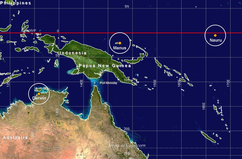
From 1996 to 2014, ARM operated the Tropical Western Pacific (TWP) atmospheric observatory. The TWP grew to include three sites―two on the remote equatorial islands of Manus and Nauru, and one in coastal and logistics-rich Darwin, Australia.
ARM also wanted a means to gather data in Earth’s polar high latitudes. Recently, surface temperatures in the Arctic have been found to be rising as much as four times the rate of warming in the midlatitudes.
During the siting process for ARM’s North Slope of Alaska (NSA) atmospheric observatory, coastal Barrow (now Utqiaġvik) won the day over candidate sites farther in the interior. In part, the 25-year-old NSA observatory owes its existence to logistical assets and a history of atmospheric observation dating to 1881.
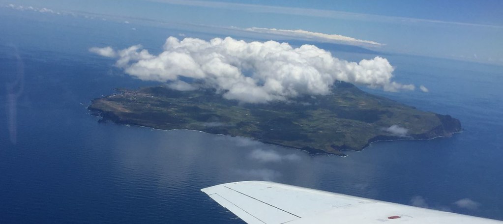
Existing infrastructure also helped ARM settle on the location of its newest fixed observatory. The Eastern North Atlantic (ENA) atmospheric observatory opened in 2013 on Graciosa Island in the Azores, about 850 miles west of mainland Portugal.
The area around the ENA remains “an important region of Earth’s oceans to study,” says Rutgers University professor Mark Miller, who was an early advocate for establishing the ENA, in part because it was downwind of the Arctic. “The Eastern North Atlantic is among the more complicated and complex cloud systems that I have ever observed. We need that site.”
Island Challenges
As in the tropical Pacific, researchers at the ENA cope with the impediments to measuring the open ocean that islands represent.
Such mid-ocean land masses, even very small ones, interrupt the otherwise unimpeded ocean winds; they create fluxes of terrestrial heat; and island radars deployed near the shoreline get signal noise from offshore waves.
Islands can even create their own clouds, a phenomenon known as the “island effect.”
Still, says Mather, “the value in getting more data outweighs the fact that you have these perturbations. If there is a phenomenon you want to study, look for the location with the best access to that. It’s a logistics trade-off.”
ARM field campaigns, sometimes centered on fixed observatories like the ENA, established a tradition of collecting marine data from instruments on land.
Glimpsing a few geographically diverse ARM observatories and campaigns illustrates the fruitful results of ocean studies from land bases.
A California Coastline Query: MASRAD
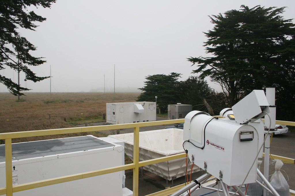
In 2005, Miller led what is arguably ARM’s first major field campaign to study ocean-atmospheric processes from a coastline.
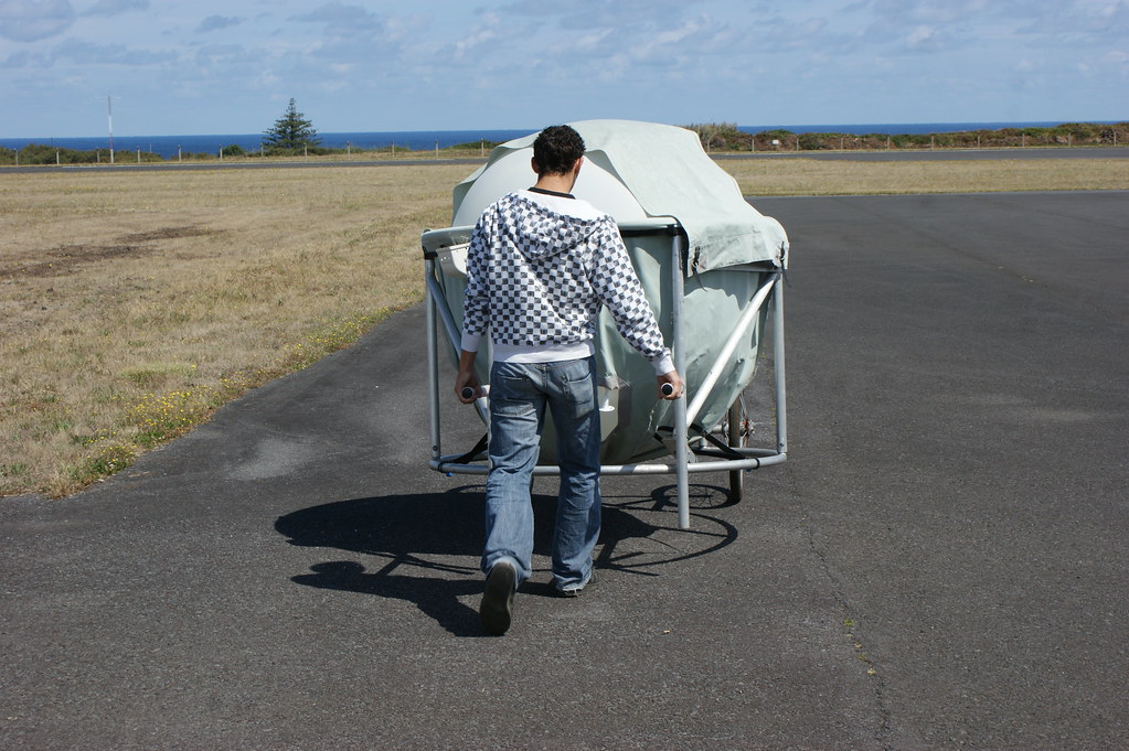
Marine Stratus Radiation Aerosol and Drizzle (MASRAD), which unfolded over six months in California, was also the first time ARM deployed one of its nimble, shippable, self-contained ARM Mobile Facilities (AMF). There are now three of these mobile observatories, which often deploy to remote regions of the world where atmospheric data are sparse.
ARM deployed MASRAD instruments about a half-mile from the ocean at Point Reyes National Seashore, an hour’s drive north of San Francisco.
The plot of land used for the MASRAD campaign was probably not what most people envision when they think “seashore.”
“We were in, basically, a pasture,” says Miller.
But instruments were close enough to acquire new data on MASRAD’s main science target―the radiative and microphysical properties of marine stratus clouds, which lie in flat, thick blankets near the sea. Miller calls them an “undersampled” part of oceanic climate systems.
Intriguingly, marine stratus clouds around Point Reyes were known to be affected by aerosols from transportation and industrial sources. Miller and others folded related inquiries into MASRAD’s science plan.
On Islands and Peninsulas: TWP-ICE, CAP-MBL, and TCAP
The TWP was ARM’s first fixed-location atmospheric observatory to host field campaigns that took advantage of island-ocean proximity.
Chief among those campaigns took place in 2006. The Tropical Warm Pool – International Cloud Experiment (TWP-ICE) used multiple aircraft, a research ship, and a wide ring of radiosonde sites around Darwin during northern Australia’s peak monsoon season. It also illustrated the ability of coastal sites to convene multi-agency international science collaborations―in this case, the United States, Australia, Canada, and the European Union.
In 2009, ARM’s island observation platforms evolved to include the user facility’s first foray into the North Atlantic Ocean, the Clouds, Aerosol, and Precipitation in the Marine Boundary Layer (CAP-MBL) campaign in the Azores.
Rob Wood at the University of Washington led CAP-MBL’s nine-month initial effort―later extended to 21 months.
CAP-MBL, which set the stage for ARM’s long-term ENA observatory, investigated the microphysics and radiative properties of the lowest mile or so of the atmosphere above the ocean. That is where experts say all the action happens: vital fluxes of heat and water exchange, as well as turbulence that rises into the cloud layer and precipitation that falls from it. Yet scientists had few detailed long-term observations, a knowledge gap ARM is trying to remedy.
ARM’s coastline inquiries swung back to the continental United States in 2012 and 2013 with a 12-month field campaign on Cape Cod in Massachusetts. Larry Berg of Pacific Northwest National Laboratory in Washington state led this campaign, the Two-Column Aerosol Project (TCAP).
The cape’s coastline, close to both urban and open-ocean environments, was ideal for getting data on aerosol, radiation, and cloud characteristics in conditions that varied from cloudy to clear as well as pristine to polluted.
TCAP planners deployed a Mobile Aerosol Observing System, an AMF, and two research aircraft. Measurements in one “column” of the atmosphere took place on land in North Truro, Massachusetts. The data were complemented by aircraft measurements within the aerosol layers.
The second column, about 120 miles eastward out to sea, provided measurements of atmospheric state and aerosol properties. Two research aircraft were deployed. One flew higher than the other, taking lidar measurements to infer the structure and reflectivity of aerosols. The second measured quantities such as temperature, humidity, and winds, as well as detailed chemical composition of the aerosol.
During a contemporaneous video interview, Berg saw “a high-quality data set” that he said would “address the uncertainty in climate models to help us get better estimates in the future.”
AWARE and Cold-Water Coasts
It’s a long way from Cape Cod to the Antarctic, a place so dry that it only gets 6.5 inches of precipitation a year.
“Antarctica is really in a logistics category of its own,” says Mather. “There’s so little real estate there where you can get infrastructure. Yet it’s so important from a climate perspective.”
Any snow that falls on the seventh continent rarely melts. Instead, it’s compressed into glaciers so thick that they contain 90% of the world’s ice.
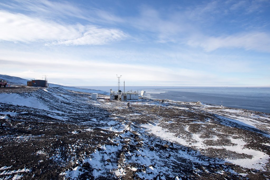
Yet melting trends in the coldest place on Earth, on the West Antarctic Ice Sheet (WAIS) especially, are a worry. That led researchers to design and execute a field campaign called the ARM West Antarctic Radiation Experiment (AWARE), which began in November 2015.
Among other things, changes in air circulation above the WAIS threaten the mechanical stability of Antarctica’s floating ice shelves, which in turn stabilize the continent’s ice sheets.
AWARE was coastal in the sense that its main instruments, in an AMF, were deployed at McMurdo Station at the southernmost extremity of Antarctica’s Ross Island.
The 14-month effort, led by Dan Lubin of the University of California San Diego’s Scripps Institution of Oceanography, was also motivated by a big knowledge gap: No substantial atmospheric or climatological work had been done on the WAIS since 1957.
He called AWARE “the single largest atmospheric and climate science field program ever sent to Antarctica.”
MICRE and Other Southern Ocean Measures
“The Southern Ocean is a particularly under-observed area. One of the great things about these (mobile) experiments is they produce data sets that we can draw on for many years and build towards a greater understanding of the Earth as a system.”
Roger Marchand, University of Washington
In March 2016, Roger Marchand at the University of Washington launched an island-based ARM investigation in the Southern Ocean, which rages around Antarctica.
The Macquarie Island Cloud and Radiation Experiment (MICRE), in collaboration with the Australian Antarctic Division and Australian Bureau of Meteorology, collected more than a year of data on clouds and precipitation. Macquarie Island is located about halfway between New Zealand and Antarctica.
MICRE researchers studied low clouds above the Southern Ocean—a chief source of uncertainty in global climate models.
Despite the importance of its clouds, “the Southern Ocean is a particularly under-observed area,” says Marchand. “One of the great things about these (mobile) experiments is they produce data sets that we can draw on for many years and build towards a greater understanding of the Earth as a system.”
Scientists are using MICRE data to understand how and why Southern Ocean clouds differ from those in other regions observed by ARM, and how these clouds are likely to change in the future.
“I am particularly excited about using data from these two experiments,” says Marchand of MICRE and AWARE.
He pointed to an upcoming ARM field campaign that will add even more about what we know about clouds in the region: the Cloud And Precipitation Experiment at Kennaook (CAPE-K), slated from April 2024 to September 2025.
CAPE-K is led by Gerald “Jay” Mace at the University of Utah. This further attempt to characterize Southern Ocean clouds and precipitation will include the deployment of an AMF to an Australian atmospheric watch station at the northwestern tip of Tasmania.
Marchand says that the locations of CAPE-K, MICRE, and AWARE are part of a region in which climate models suggest low clouds “are likely to change in very different and important ways.”
COMBLE and Cold-Air Outbreaks
Data are also sparse on global phenomena called cold-air outbreaks (CAOs), which are cloud-formation processes tied to very cold air moving over relatively warm water. ARM addressed this in 2019 and 2020 with the Cold-Air Outbreaks in the Marine Boundary Layer Experiment (COMBLE) led by Bart Geerts at the University of Wyoming.
For COMBLE, ARM deployed an AMF on the island of Andøya in northern Norway. That’s on the coast of the Norwegian Sea, which spans more than 500,000 square miles and is linked to both the Atlantic and Arctic oceans.
The campaign also included a second instrumented site, on Bear Island, 310 miles north of mainland Norway.
That gave COMBLE “two quasi-marine sites,” says Mather.
With COMBLE’s rich and exciting data, “we are learning much about this CAO cloud regime,” says Geerts of ongoing observational research. “The next step is up to modelers.”
For modelers simulating the impact of CAOs on the climate system, he adds, it is necessary to represent the effects of COMBLE-observed heat fluxes, boundary-layer developments, and cloud processes.
The South and North Atlantic: LASIC and ACE-ENA
Starting in the summer of 2016 in the tropical South Atlantic, ARM conducted a 17-month investigation of the effect of smoke-related aerosols on stratocumulus clouds in the marine boundary layer.
Paquita Zuidema at the University of Miami led the Layered Atlantic Smoke Interactions with Clouds (LASIC) field campaign. LASIC set up its ground instruments on Ascension Island, a speck of volcanic rock south of the equator and 1,000 miles west of Africa.
The placement was clever and apt. Ascension is right in the path of a westward-streaming smoke-cloud system created by seasonal wildfires in Africa. It influences the solar reflectivity of stratocumulus.
Before LASIC, such smoke-cloud systems were largely characterized only by satellite data. Over its all-season run, LASIC provided many close-up measurements of how smoke affected cloud cover.
The aerosols from Africa are capable of absorbing sunlight, which has a warming effect on the planet. They also influence when, how much, and where it rains―often reducing precipitation overall.
Today, says Zuidema, modelers are using LASIC data to “ultimately improve smoke-cloud interaction modeling on a global scale, supporting more robust predictions of future climate.”
LASIC still had five months to run when the clock started to run on another field campaign in the Atlantic―3,300 miles north in a separate ocean regime.
The Aerosol and Cloud Experiments in the Eastern North Atlantic (ACE-ENA) campaign combined the synergy of surface instruments at ARM’s ENA observatory on Graciosa Island with aerial measurements. During two separate deployments spanning 2017 and 2018, ARM’s research aircraft was based at nearby Terceira Island.
Principal investigator Jian Wang of Washington University in St. Louis, with CAP-MBL’s Wood as one of 25 co-investigators, gathered data on little-understood marine low clouds, which greatly influence Earth’s climate. That required collecting surface and air measurements on the structure of the marine boundary layer, vertical distribution, and the effect of regional aerosols on clouds and precipitation.
The aerosol instrumentation used during ACE-ENA was so sensitive, Wang recalls, that it recorded whenever someone started cooking.
Two Cracks at Coastal Clouds: TRACER and EPCAPE
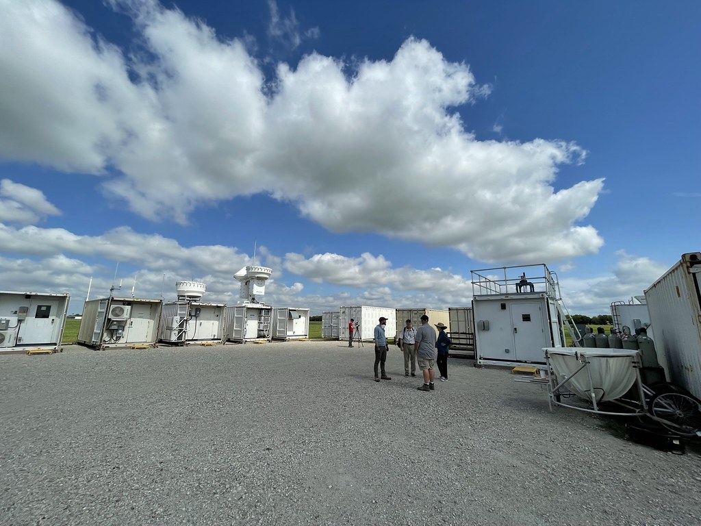
Wang was also involved in ARM’s TRacking Aerosol Convection interactions ExpeRiment (TRACER), a 2021–2022 field campaign in the Houston, Texas, region.
TRACER is among what Mather calls “true coastal” campaigns―that is, those intended to study both land and ocean and how the two interact. Many other campaigns along coastlines, he says, represent “locations of opportunity” used to study ocean processes from a logistically solid land base.
Wang’s work took place in July and August 2022. It focused on cloud condensation nuclei, especially the degree to which they take up water. It was among many smaller campaigns linked to TRACER, with at least 10 funded by DOE’s Atmospheric System Research (ASR) program.
“I don’t think there has ever been another urban coastal study like this,” said TRACER Principal Investigator Michael Jensen of Brookhaven National Laboratory in New York in late 2022, when the campaign swung from making observations to analyzing data and making models.
He adds: “Many of the first TRACER research activities are looking at how the coastal circulations―that is, the sea breezes and bay breezes―impact the environment around the ARM sites and the cloud and aerosol properties that were observed.”
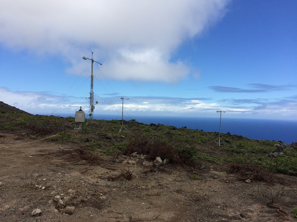
As with TRACER, the ocean coastline―more than the ocean itself―is the science target of an ARM campaign that began in Southern California in February 2023.
The primary mission of the 2023–2024 Eastern Pacific Cloud Aerosol Precipitation Experiment (EPCAPE) is to investigate coastal aerosol influences on the marine stratocumulus clouds that hug the coastline of La Jolla.
EPCAPE’s principal investigator is Lynn Russell at Scripps Institution of Oceanography. Lubin of AWARE and Miller of MASRAD join her as co-investigators.
The campaign picks up on MASRAD’s theme of investigating the influences of human-made aerosols on climate-critical cloud regimes. EPCAPE is looking at marine stratocumulus clouds, which have a net cooling effect on surface temperatures.
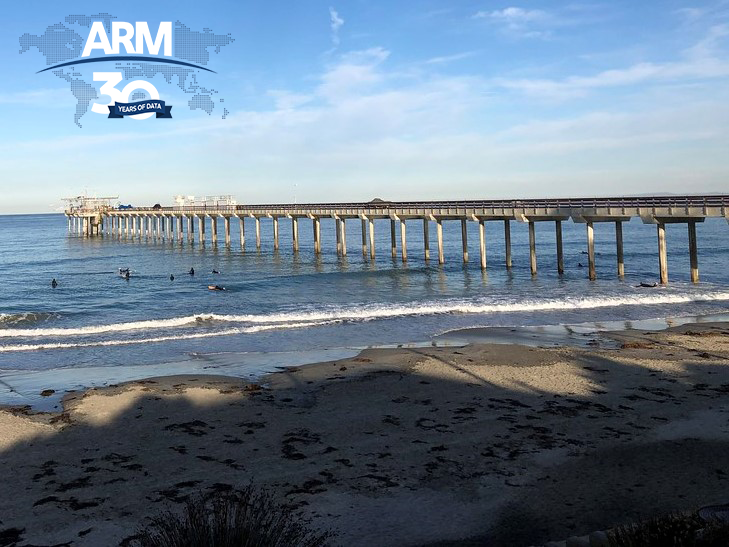
The new campaign benefits from not only instrument advances of the last two decades, but also from location: main measurement assets along the Ellen Browning Scripps Memorial Pier, backed by a secondary instrument site a half-mile inland and 820 feet up on Mount Soledad.
During an interview on the pier with a Spanish-language television station in mid-February, Russell called EPCAPE “a super-exciting project―and it’s going to be the best characterization of clouds and airborne particles that Southern California has really ever seen.”
Targeting coastal clouds required being on the coast, she added, “so we have that interface between the marine ocean and our continental (influences). It turns out that’s a pretty complicated thing.”
Follow Us:


Keep up with the Atmospheric Observer
Updates on ARM news, events, and opportunities delivered to your inbox
ARM User Profile
ARM welcomes users from all institutions and nations. A free ARM user account is needed to access ARM data.


