

Second ARM Mobile Facility Enters Second Decade of Deployments
Published: 25 August 2021
Now in central Colorado, the mobile facility is beginning its longest deployment to date
The Atmospheric Radiation Measurement (ARM) user facility will be in somewhat familiar territory for a field campaign that starts formal operations on September 1, 2021.
More than a decade ago, the second ARM Mobile Facility (AMF2) made its field campaign debut in the Colorado Rockies.
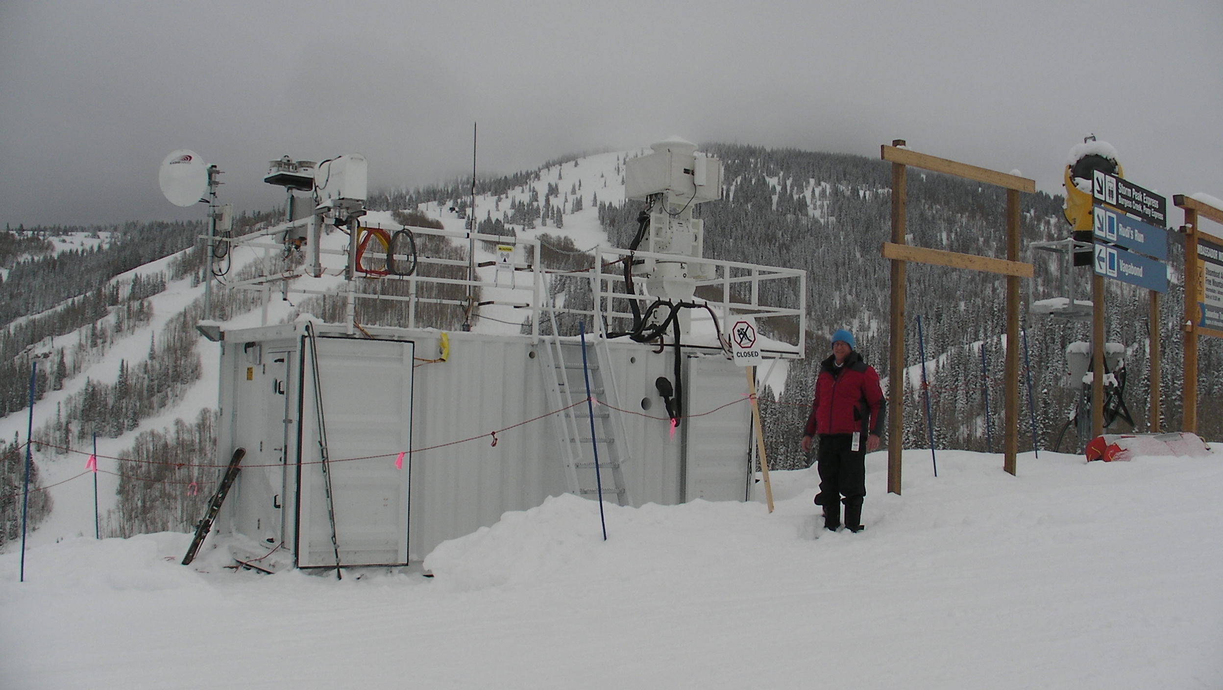
From November 2010 to April 2011, the Storm Peak Lab Cloud Property Validation Experiment (STORMVEX) measured properties of wintertime clouds and precipitation. Based in the ski town of Steamboat Springs, AMF2 contributed to data collection at multiple altitudes.
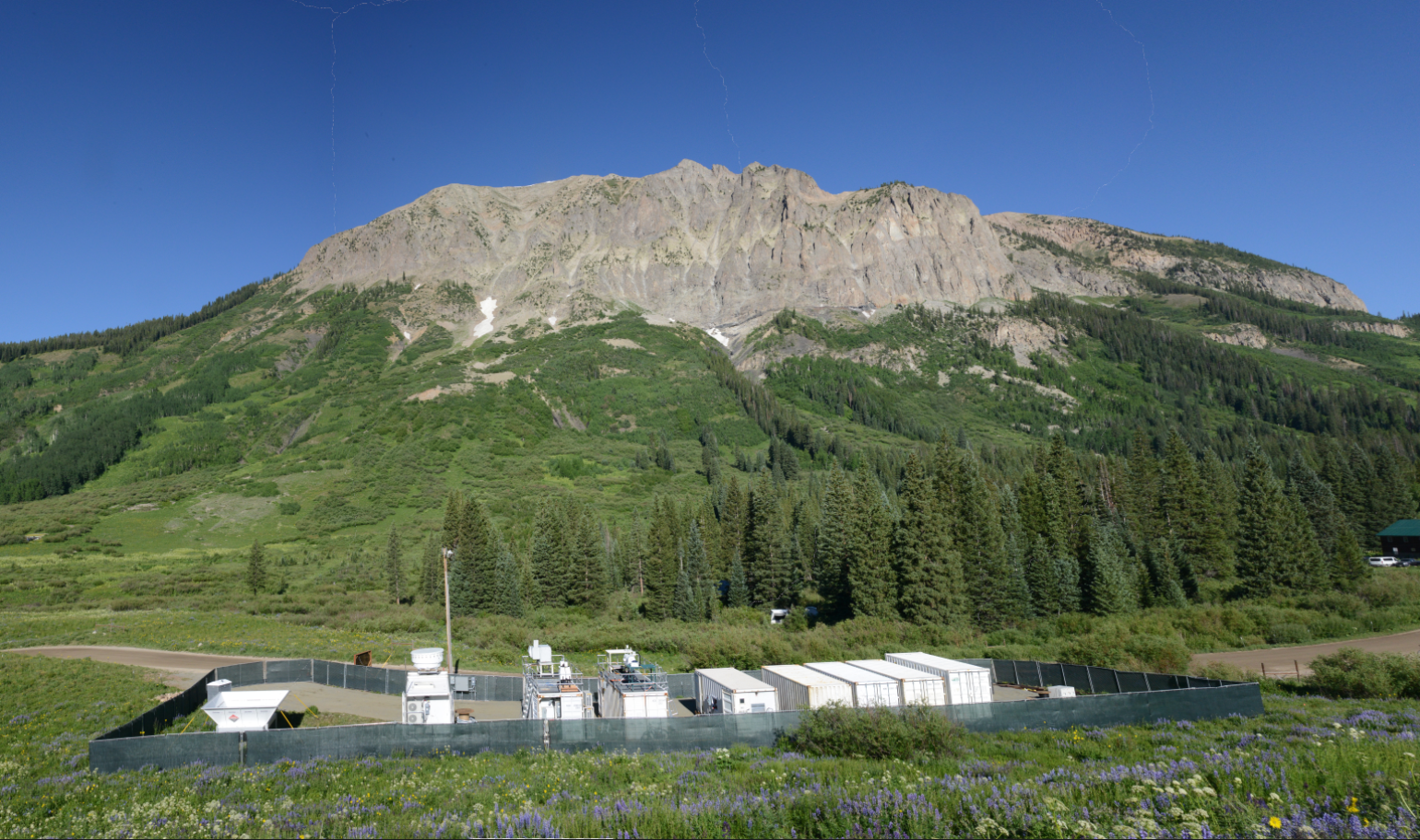
Now, AMF2 is back in the Colorado Rockies for a 21-month campaign aimed at helping researchers learn more about processes driving mountain hydrology. The Surface Atmosphere Integrated Field Laboratory (SAIL) campaign near Crested Butte will be AMF2’s longest deployment to date.
In its first 10 years, AMF2 expanded ARM’s ability to gather data in remote, climate-critical regions of the world. ARM typically deploys more than 50 instruments with its mobile facilities to gather measurements related to clouds, precipitation, aerosol particles, energy, and other meteorological variables. In between its Colorado deployments, AMF2 has traveled on ships across oceans, operated in a snowy forest and in the tropics, and gone to the top and bottom of the Earth.
AMF2 has also increased ARM’s value within the modeling community. Modelers need more observations to accurately simulate atmospheric processes in under-observed regions, such as the Southern Ocean and the central Arctic. (AMF2 has been to both regions.)
The Role of AMF2 and Its Beginnings
ARM has two other mobile facilities. The first, which has collected data since 2005, is being installed for a yearlong campaign in Texas starting in October 2021. The third, which came online in 2013, just completed an extended deployment at Oliktok Point, Alaska, and will soon deploy to the Southeastern United States.
The three mobile facilities are not entirely one and the same.
“We’ve designed them to, in a lot of ways, be interchangeable with respect to instrumentation, but as far as the containers and the facility equipment, they’re built for a more specific purpose,” said ARM Associate Director for Operations Nicki Hickmon, a former AMF2 technician, installer, and site manager.
Recognizing the need to collect more atmospheric data out in the open ocean, the U.S. Department of Energy (DOE) Office of Science in 2008 awarded a contract to design, build, and operate AMF2. Argonne National Laboratory in Illinois oversaw the design, construction, and early operations. The operations of AMF2 transitioned to Los Alamos National Laboratory in New Mexico in 2015.
To support ocean-based deployments, AMF2 incorporated platforms that could withstand ship motion, instruments to observe the properties of the ocean surface, and wireless communication technology.
AMF2 also had a design that minimized its footprint for land campaigns, making it a nice fit for STORMVEX. An ARM team installed AMF2 near Storm Peak Laboratory and its array of aerosol, cloud, and precipitation sensors.
A year ago, Storm Peak Lab Director Gannet Hallar wrote that the AMF2 deployment “created a correlative data set equivalent to approximately 300 aircraft flights in mixed-phase clouds.”
STORMVEX’s lead scientist, Gerald “Jay” Mace, said that some of those data took seven or eight years to process because of their uniqueness. This contributed to a slowdown in journal articles after an early spate of papers from the campaign.
“We’re definitely not finished with STORMVEX data. There’s no better in situ characterization of snow. I don’t think there’s anything like it that has been collected, at least in that temperature regime.”
Gerald “Jay” Mace, lead scientist for the STORMVEX campaign
“Collecting cloud and snow particles from a mountaintop with probes that were designed for aircraft, it took us a while to figure out how to work with that,” said Mace, a professor of atmospheric sciences at the University of Utah. “And nobody had ever scanned a W-band radar, sort of like we did at that point, it had never been done, especially on a mountaintop or on the side of a mountain.”
A new paper co-authored by Hallar appeared in 2020, using data from STORMVEX and four other ARM sites to test a new method for predicting the total volume of aerosol particles.
“We’re definitely not finished with STORMVEX data,” said Mace. “There’s no better in situ characterization of snow. I don’t think there’s anything like it that has been collected, at least in that temperature regime.”
In the SAIL science plan, investigators wrote that they plan to complement and build off STORMVEX findings: “Given the geographic proximity of the STORMVEX measurements to those of the SAIL site, the types of clouds observed and the roles of aerosols in clouds and precipitation at the two sites can and should be compared.”
Near and On the Water
Less than a year after STORMVEX, AMF2 made its first non-U.S. trip to the Maldives for the ARM Madden-Julian Oscillation (MJO) Investigation Experiment on Gan Island (AMIE-Gan).
The MJO is a disturbance of clouds, rainfall, and wind that recurs every 30 to 90 days during the Northern Hemisphere winter, forming over the Indian Ocean and moving eastward out to the Pacific. AMIE-Gan was part of a set of coordinated MJO-focused campaigns, including AMIE-Manus at ARM’s now-retired Tropical Western Pacific site on Manus Island, Papua New Guinea.
Speaking to the challenges of operating ARM Mobile Facilities around the world, data collection at Gan ended about seven weeks early because of sudden unrest in the Maldives. Technical staff and equipment safely left Gan, and AMIE data collection continued at Manus through the scheduled end of the campaign in March 2012.
The lead scientist for the AMIE campaigns, Chuck Long, passed away in 2019, but his AMIE work continues to have an impact within the scientific community. Researchers are still using data from AMIE-Gan, AMIE-Manus, and other coordinated campaigns to better understand MJO processes and improve their representation in earth system models. A recent search of ARM’s publications database pulled up 78 journal articles connected to both AMIE campaigns, including 11 published in 2020 and 2021.
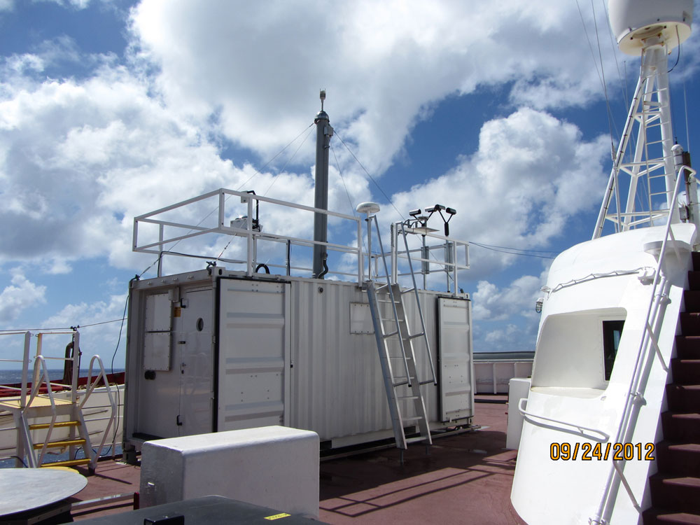
Scientists are also still digging into data from AMF2’s first shipboard campaign, the Marine ARM GPCI Investigation of Clouds (MAGIC). From October 2012 through September 2013, AMF2 operated on a cargo ship traveling back and forth between Honolulu, Hawaii, and Los Angeles, California.
The data from MAGIC enable researchers to study the transition from low drizzly stratocumulus cloud decks near California to popcorn-like cumulus clouds closer to Hawaii.
“MAGIC, at the time, was the largest or one of the largest radar studies ever done at sea,” said MAGIC’s lead scientist, Ernie Lewis from Brookhaven National Laboratory in New York. “And even so, we only had about 200 days at sea in total. But still, that was an amazing amount of time to collect data and measurements. We had three radars going the whole time, we had aerosol measurements, we measured fluxes. We collected a very rich data set there, going back and forth between L.A. and Hawaii.”
The MAGIC data are full of riches for modelers. A 2020 paper described a study to assess how well the single-column model in version 1 of DOE’s Energy Exascale Earth System Model (E3SM) simulated the transition of precipitating marine stratocumulus clouds to cumulus. Comparing the model with observations and a large-eddy simulation from MAGIC, researchers found that the model struggled with precipitation and identified possible causes.
Quick Jaunts
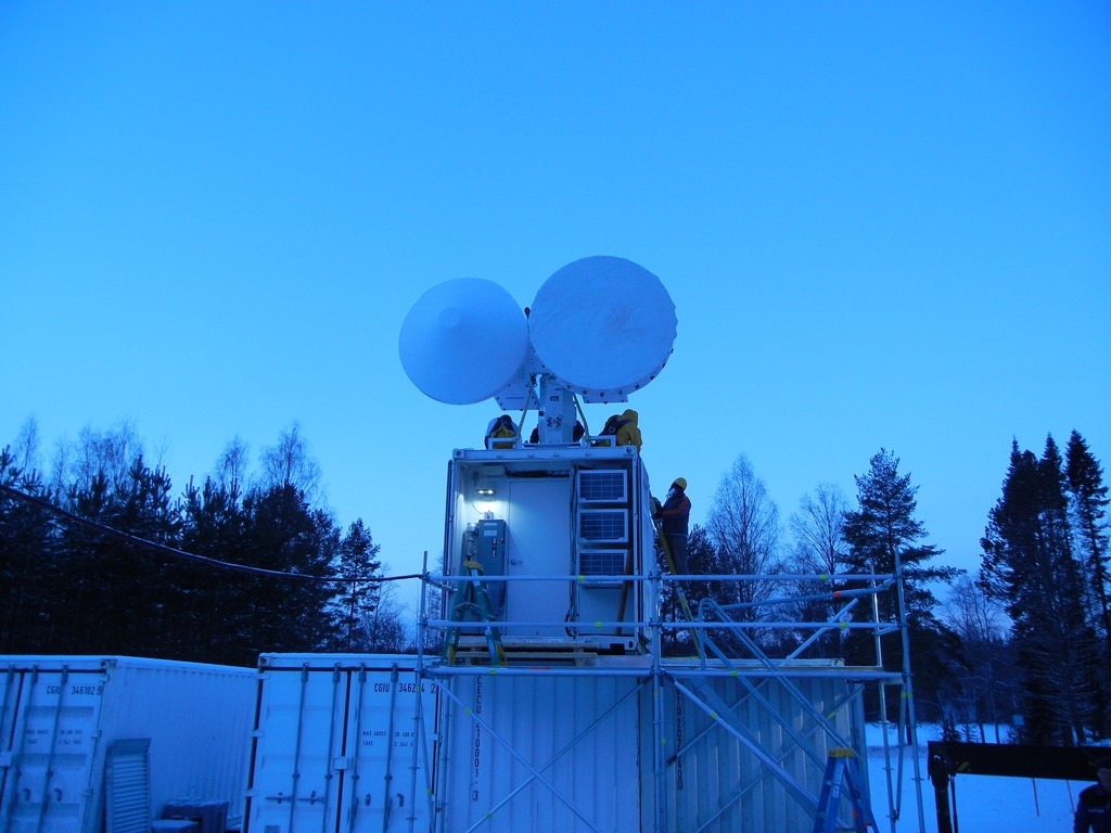
In 2014, AMF2 returned to land—a Finnish forest, more specifically—for the 7.5-month Biogenic Aerosols – Effects on Clouds and Climate (BAECC) field campaign. Led by Tuukka Petäjä at the University of Helsinki in Finland, BAECC provided important new data on snow and ice microphysics.
Co-investigator Dmitri Moisseev said in 2018 that BAECC was also the first campaign in which researchers “tried to make the link between biogenic (naturally occurring) aerosols and clouds. And because of BAECC, we have decided to continue these kinds of observations.”
So far, BAECC has produced the most journal articles (44) out of the eight completed AMF2 campaigns.
A few months after BAECC, AMF2 gathered data on a NOAA research vessel traveling from Hawaii to California as part of the ARM Cloud Aerosol Precipitation Experiment (ACAPEX). Running from January to March 2015, ACAPEX was a short but impactful campaign.
ACAPEX, which included flights of ARM’s now-retired Gulfstream-159 (G-1) research aircraft, took place in conjunction with NOAA’s CalWater2 campaign, with NASA and National Science Foundation participation. Together, these campaigns collected data to better understand atmospheric rivers—long, narrow bands of water vapor that snake through the atmosphere and dump massive amounts of rain after they make landfall in mountainous terrain. L. Ruby Leung, a scientist at Pacific Northwest National Laboratory in Washington state, led the ACAPEX campaign.
The combination of ship-based and aircraft data from ACAPEX has allowed for multifaceted research of atmospheric rivers. For example, a 2019 paper co-authored by Leung focused on characteristics of ice-nucleating particles (INPs) sampled during ACAPEX. (Such particles serve as nuclei for the formation of ice crystals in the atmosphere.) Analyzing data from the G-1, the NOAA ship, and a ground station on the Northern California coast, researchers discovered the dominance of marine INPs during an atmospheric river event. This was different from earlier CalWater campaigns, in which dust and biological particles were the primary INPs found in atmospheric river events.
Leung, now the chief scientist of DOE’s E3SM project, said that two new ACAPEX papers are in the works.
To the Ends of the Earth, Part 1
After ACAPEX, AMF2 spent the better part of the next five years getting acquainted with the southernmost and northernmost reaches of the Earth.
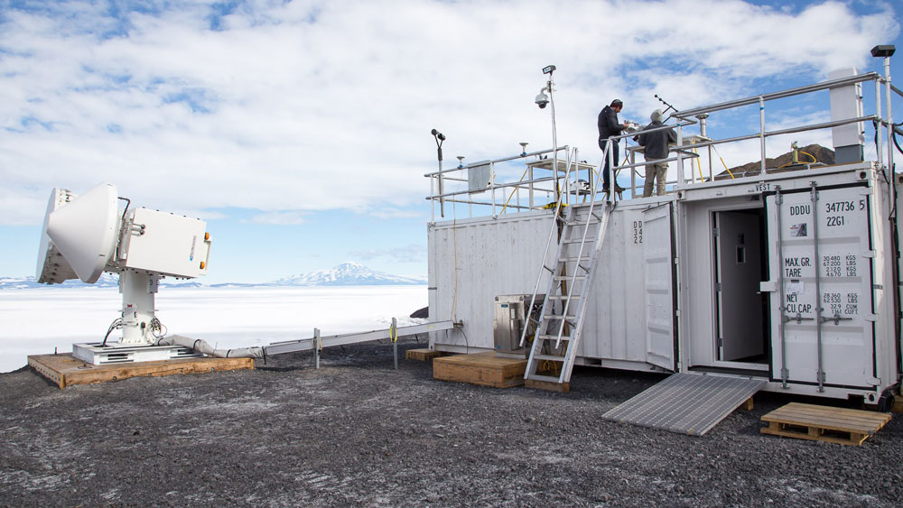
First, AMF2 collected data at McMurdo Station, Antarctica, as part of the 2015–2017 ARM West Antarctic Radiation Experiment (AWARE). A joint effort between DOE and the U.S. Antarctic Program, AWARE was the most comprehensive meteorological campaign in West Antarctica in 50 years.
A paper led by AWARE’s lead scientist, Dan Lubin, appeared in the Bulletin of the American Meteorological Society (BAMS) in July 2020. The paper detailed early results from AWARE, including data analysis that revealed differences in cloud physics and aerosol composition between Antarctica and the Arctic.
There are 23 AWARE-related papers in ARM’s publications database, with six published in 2021 alone.
Toward the end of 2017, AMF2 was on a supply ship going back and forth across the Southern Ocean between Hobart, Australia, and three Australian Antarctic research stations. These voyages were part of the Measurements of Aerosols, Radiation, and Clouds over the Southern Ocean (MARCUS) campaign, which ended in April 2018. Lead scientist Greg McFarquhar said afterward that MARCUS provided “really the first set of comprehensive data that describe the seasonal properties of clouds and aerosols south of the oceanic polar front (60 degrees south).”
Recently, MARCUS was featured in a BAMS overview paper on Southern Ocean field campaigns. McFarquhar co-convened a breakout session on high-latitude marine postfrontal clouds during the Joint ARM User Facility/Atmospheric System Research (ASR) Principal Investigators Meeting in June 2021. (A follow-on virtual workshop will take place in September 2021.)
To the Ends of the Earth, Part 2
Out in the Southern Ocean’s choppy waters, technicians had to battle sea spray and rocking and rolling of the supply ship.
“Measurements from ships require a whole other level of coordination and planning,” said Heath Powers, AMF2 site manager from Los Alamos National Laboratory.
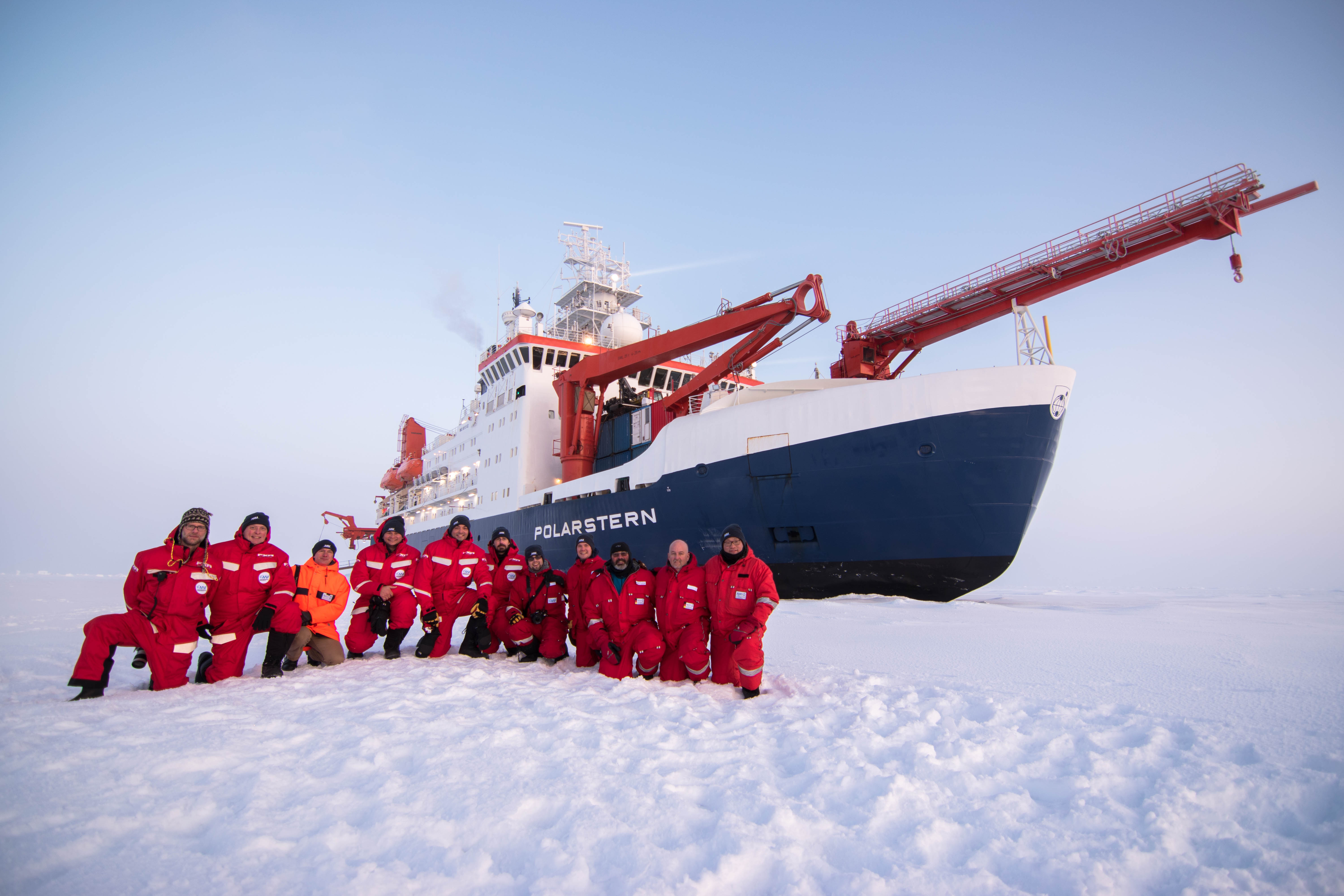
AMF2’s most recent completed deployment might have raised the ambition level as well. The mobile facility operated on an icebreaker frozen into an ice floe in the central Arctic during the 2019–2020 Multidisciplinary Drifting Observatory for the Study of Arctic Climate (MOSAiC) expedition. ARM also had some instruments out on the ice.
The MOSAiC team worked through a set of challenges that differed from past ship-based campaigns, including thinning and shifting sea ice, prolonged darkness, arctic cyclones, and a pandemic. Technicians rotated in and out of the Arctic for a year to keep ARM instruments operating during the expedition.
ARM MOSAiC data are part of what expedition co-coordinator Matthew Shupe called “the most comprehensive set of observations ever made in the central Arctic.” Shupe made this proclamation during the virtual 2020 American Geophysical Union (AGU) Fall Meeting as part of a press conference on the state of the Arctic.
“There’s a tremendous data legacy that will feed the arctic research community for years,” he added.
Like data from all past ARM Mobile Facility deployments, most MOSAiC data sets are available online. Value-added products from the expedition have begun to appear in the ARM Data Center.
On to SAIL
Now, AMF2 is set up at Gothic, Colorado, for the SAIL campaign, led by Daniel Feldman from Lawrence Berkeley National Laboratory in California. The main AMF2 site is just up the road from Crested Butte Mountain, where a scanning precipitation radar and ARM Aerosol Observing System will also operate during SAIL.
Observations from SAIL, combined with information from a long-term DOE scientific focus area project in the East River Watershed, will give researchers an atmosphere-through-bedrock understanding of how water travels through the mountains.
SAIL promises to add to AMF2’s legacy.
After SAIL, said Feldman in a July 2021 DOE Atmospheric System Research profile, “we’re going to be thinking hard about what the data have told us and how we can ask and answer questions we couldn’t ask and answer before.”
Of course, he added, “the science articles (to be published afterward) are the fun part. We will have collected a substantial amount of data we can sink our teeth into for quite some time.”
Follow Us:


Keep up with the Atmospheric Observer
Updates on ARM news, events, and opportunities delivered to your inbox
ARM User Profile
ARM welcomes users from all institutions and nations. A free ARM user account is needed to access ARM data.


