

ARM Rolls Out New Products for Determining Boundary-Layer Height
Published: 26 January 2023
The structure and depth of the planetary boundary layer (PBL) are important to a wide range of atmospheric processes. Such processes include cloud formation and aerosol and chemical mixing, transport, and transformation.
Errors in the determination of PBL height can significantly affect the formation and maintenance of low-level clouds and the initiation of convective clouds in models. Numerous instruments and algorithms have been used for PBL height estimation, each with its own strengths and weaknesses.
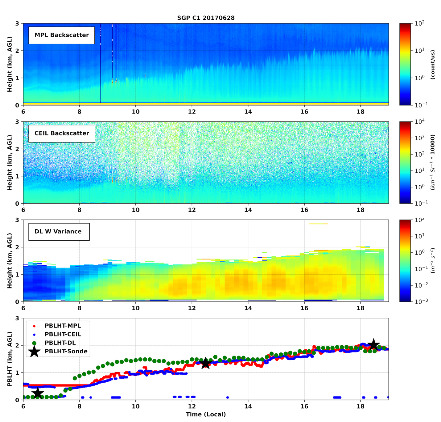
To that end, ARM now offers value-added products that provide PBL height estimates from lidar measurements. Planetary Boundary Layer Height (PBLHT) products derived from micropulse and Doppler lidar data are now available for evaluation.
The micropulse and Doppler lidar versions complement previously released products that estimate PBL height from ARM radiosonde profiles and ceilometer data. Scientists can evaluate and compare estimates from ARM’s various PBLHT products.
Currently, the Doppler lidar product (PBLHTDL) covers the period from October 22, 2010, to December 31, 2019, at ARM’s Southern Great Plains (SGP) atmospheric observatory.
The micropulse lidar product (PBLHTMPL) derives the PBL height from micropulse lidar data by using the Sawyer and Li (2013) method, which combines and applies two common techniques for detecting PBL depth—wavelet covariance and iterative curve-fitting—to micropulse lidar backscatter profiles to derive the PBL height.
Currently, PBLHTMPL is available for the years 2009–2010 and the period from January 1, 2014, to August 31, 2020, at the SGP observatory. PBLHTMPL is also available for the 2018–2019 Cloud, Aerosol, and Complex Terrain Interactions (CACTI) field campaign in Argentina.
A PBLHT product derived from Raman lidar data is under development.
Get more information about PBLHTMPL and PBLHTDL on the PBLHT products page.
Access the PBLHTMPL and PBLHTDL data in the ARM Data Center. (Go here to create an account to download the data.)
Please contact ARM translator Damao Zhang with questions or feedback about the evaluation data.
To cite the PBTHTMPL data, please use doi:10.5439/1637942. For citing PBLHTDL, please use doi:10.5439/1726254.
Reference: Sawyer V and Z Li. 2013. “Detection, variations and intercomparison of the planetary boundary layer depth from radiosonde, lidar and infrared spectrometer.” Atmospheric Environment, 79, https://doi.org/10.1016/j.atmosenv.2013.07.019.
Follow Us:


Keep up with the Atmospheric Observer
Updates on ARM news, events, and opportunities delivered to your inbox
ARM User Profile
ARM welcomes users from all institutions and nations. A free ARM user account is needed to access ARM data.


