

PBLHT
Planetary Boundary Layer Height
Baseline VAP, Evaluation VAP
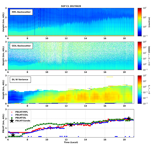 The structure and depth of the planetary boundary layer (PBL) play a crucial role in various atmospheric processes, including cloud formation and aerosol and chemical mixing, transport, and transformation. Errors in the determination of PBL height can significantly affect the formation and maintenance of low-level clouds and the initiation of convective clouds in models. Numerous instruments and algorithms have been used for PBL height estimation, each with its own strengths and weaknesses.
To that end, ARM has developed a set of Planetary Boundary Layer Height (PBLHT) value-added products that scientists can use to evaluate and compare estimates. ARM’s PBLHT products are derived from micropulse lidar (PBLHTMPL), Doppler lidar (PBLHTDL), and radiosonde data (PBLHTSONDE).
In addition, ARM hosts ceilometer-derived estimates of PBL height (CEILPBLHT), which are produced directly from vendor-provided instrument operation software.
Primary Derived Measurements
Contact
View all contacts-
Damao ZhangTranslator Pacific Northwest National Laboratory
Related Data Announcements
References
View all references- Zhang et al. "Aerosol Influences on Cloud Water: Insights from ARM EPCAPE Observations with Explainable Machine Learning". 2025. 10.1029/2025GL115163.
Locations
Follow Us:


Keep up with the Atmospheric Observer
Updates on ARM news, events, and opportunities delivered to your inbox
ARM User Profile
ARM welcomes users from all institutions and nations. A free ARM user account is needed to access ARM data.


