

Flying ARM’s Friendly Skies
Published: 20 August 2018
Outside campaigns and agencies routinely sample the atmosphere above ARM observatories
On March 10, researchers from the United Kingdom and Canada launched a 15-day airborne campaign intended to improve the ways the radiative effects of snow are represented in weather prediction models.
At least once during the operation, the campaign’s four-engine modified Bae 146-301 overflew an Atmospheric Radiation Measurement (ARM) user facility site in Barrow (officially known as Utqiaġvik), Alaska. The site is part of the North Slope of Alaska (NSA) atmospheric observatory run by ARM, a longtime operation of the U.S. Department of Energy.
That overflight was a reminder that research aircraft (and other airborne devices) frequently sample the atmosphere over ARM sites around the world. Included are instrumented planes, tethered balloons, unmanned aerial systems, and satellites. The combination of ARM ground-based measurements with measurements from aerial and satellite platforms provides benefits to both.
In March, the British-Canadian campaign and its airborne platform focused on improving satellite data woven into operational weather prediction models.
There were also efforts to investigate arctic stratus clouds, in particular how they formed and decayed.
It was this attempt to characterize boundary layer conditions affecting stratus cloud formation that required flying over the NSA.
The campaign in question, Measurements of Arctic Cloud, Snow and Sea Ice in the Marginal Ice ZonE (MACSSIMIZE), was carried out from May 2017 to June 2018 as part of the Year of Polar Prediction (YOPP), a core piece of a 10-year international effort to improve meteorological and environmental prediction in the world’s polar areas.
Overflights in Oklahoma and the Azores
Jennifer Comstock, ARM’s engineering and process manager, quickly lists a few other such friendly overflights.
NASA had two campaigns over ARM’s Southern Great Plains (SGP) atmospheric observatory, she says. Both focused on cirrus clouds and involved NASA’s high-altitude WB-57 aircraft.
One happened in 2004, when NASA performed its Middle Latitude Cirrus Experiment (MidCix) using SGP airspace. In one flight, on May 3 that year, the WB-57 spiraled up and down the SGP, stacked with instruments that measure small amounts of ice in cloud regions with a high water vapor content.
During the spring of 2011, NASA launched the Mid-Latitude Airborne Cirrus Properties Experiment (MACPEX), an investigation of cirrus cloud properties and the processes that influence their effect on radiation. Its mission emphasized measurement flights over the SGP.
In both cases, flights over the SGP were conducted in part so scientists could combine the information on cloud vertical structure from the ARM radars and lidars with the extensive in situ measurements of cloud horizontal and microphysical structure from the aircraft observations.
During ARM’s Layered Atlantic Smoke Interactions with Clouds (LASIC) field campaign in 2016 and 2017, NASA ran an associated experiment designed to study persistent low-level clouds mixed with tiny aerosols from southern Africa, where almost one-third of the Earth’s biomass burning occurs. ObseRvations of Aerosols above CLouds and their intEractionS (ORACLES) is a five-year investigation punctuated by three intensive campaigns. ORACLES involves two NASA research aircraft flying transects (patterned flights) over the southeast Atlantic Ocean.
In the Amazon
During the Green Ocean Amazon (GoAmazon2014/15) field campaign in Brazil, says Comstock, an aircraft from a European campaign coordinated its flights with ARM’s Gulfstream-159 (G-1) research aircraft.
The European ground-air experiment, which wrapped up in October 2014, was designed to help quantify aerosol–cloud–precipitation interactions.
It was part of a German-Brazilian campaign that deployed a new German High Altitude and Long Range Research Aircraft (HALO) platform.
Unmanned Aerial Systems
ARM Associate Director for Operations Nicki Hickmon, whose home base is Argonne National Laboratory in Illinois, provided another list of ARM observatory overflights.
Two of the overflights involved unmanned aerial systems (UAS) and took place in the skies over the SGP.
The National Science Foundation funded a five-year, four-university project that will wrap up in 2019. Researchers involved in the Collaboration Leading Operational UAS Development for Meteorology and Atmospheric Physics (CLOUD-MAP) are trying to develop integrated UAS to enhance atmospheric physics measurements in the lower atmospheric boundary layer.
Their three-day research flights̶—in precise spiral patterns—started in 2016. Within a year they had racked up 70 hours of coordinated flight. Involved were a variety of unmanned aircraft, including fixed-wing platforms and at least one rotary platform used to sense methane.
In October 2016, the National Oceanic and Atmospheric Administration (NOAA) used the SGP observatory to run its Environmental Profiling and Initiation of Convection Field Campaign (EPICFC). The object was to evaluate UAS platforms that could profile the lower atmosphere to determine the potential for severe weather.
Balloons and Satellites Both
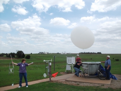
Radiosondes attached to balloons have at least an 80-year history of providing measurements of temperature, humidity, wind, and other critical factors in the atmosphere, according to a 2016 paper comparing radiosondes that was co-authored by Donna Holdridge, ARM’s Argonne-based instrument mentor for balloon-borne sounding systems.
Today these same instruments—hitched to helium-filled balloons that can rise as high as 25,000 meters (about 82,000 feet)—are also used to validate data from satellites.
“They help perfect satellite technology,” says Holdridge.
ARM routinely launches two to four radiosondes a day at its three fixed and three mobile observatories—5,000 such launches a year.
Since 2012, some of those radiosondes launches from the NSA and SGP have been coordinated with satellites in the Joint Polar Satellite System (JPSS), an interagency polar-orbiting system named by NOAA and run with NASA since 2011.
Similar coordinated radiosonde-satellite launches have also taken place at ARM’s Eastern North Atlantic (ENA) atmospheric observatory since early 2015.
JPSS satellites cross the equator 14 times a day in pole-to-pole observation patterns to collect key data on temperature, vegetation, clouds, rainfall, and other critical measures.
NASA calls its satellite fleet the Suomi National Polar-orbiting Partnership. The agency has a series of satellites in orbit, known collectively as the Earth Observing System.
Far below, humble balloon launches from places such as the ARM sites, validate satellite measurements at a cost of less than $400 per launch.
“It’s old-school,” said Holdridge of the balloon-radiosonde technology, where instruments “are in the environment. It’s a classic way to collect data. Scientists love it. Modelers love it.”
The SGP, NSA, and ENA observatories are part of a current balloon-satellite ARM field campaign called Radiosonde Intercomparison and Validation (RIVAL). Holdridge works with its lead scientist, Lori Borg of the University of Wisconsin, Madison, who is part of the NASA Airborne Science Program.
Approved in 2017, RIVAL includes technicians performing weekly launches at the three ARM observatories, in part to compare an older Vaisala radiosonde technology (RS92) with a new one (RS41). The launches occur at satellite overpass times.
Overflights of ARM observatories are routine and welcome, given the collaborative imperative of ARM data.
Certainly that’s true in the satellite-balloon coordination arena. RIVAL, for one, has just been extended for another year.
The ARM Climate Research Facility is a DOE Office of Science user facility. The ARM Facility is operated by nine DOE national laboratories.
Follow Us:


Keep up with the Atmospheric Observer
Updates on ARM news, events, and opportunities delivered to your inbox
ARM User Profile
ARM welcomes users from all institutions and nations. A free ARM user account is needed to access ARM data.


