An official website of the United States government
Official websites use .gov A
.gov website belongs to an official government
organization in the United States.
Secure .gov websites use HTTPS A
lock (
) or https:// means you’ve safely connected to
the .gov website. Share sensitive information only on official,
secure websites.
A new data product—the Cloud Type Classification (CLDTYPE) value-added product (VAP)—provides an automated cloud type classification based on macrophysical quantities derived from vertically pointing lidar and radar. Up to 10 layers of clouds are classified into seven cloud types based on predetermined and site-specific thresholds of cloud top height, cloud base height, and thickness.
Inputs for the CLDTYPE VAP include lidar and radar cloud boundaries from the Active Remotely Sensed Cloud Location (ARSCL) and data from the Surface Meteorological Systems (MET). Rain rates from MET are used to determine when radar signal attenuation precludes accurate cloud detection. Temporal resolution and vertical resolution for CLDTYPE are 1 minute and 30 meters respectively and match the resolution of ARSCL.
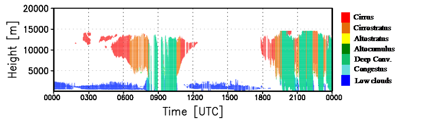
A time series is shown here of cloud types classified based on ARSCL cloud boundaries. Observations are taken at the ARM Southern Great Plains atmospheric observatory on May 24, 2008.
An initial step for further categorization of clouds, the CLDTYPE classification VAP was developed for use by the Shallow Cumulus VAP to identify potential periods of interest for the LASSO model. The CLDTYPE VAP is also intended to help users find clouds of interest for a variety of research purposes.
Data from the CLDTYPE VAP are currently available for the Southern Great Plains (SGP) and Tropical Western Pacific (TWP) observatories because of their long historical records. Additional data from the SGP will be run operationally on ARSCL data as it becomes available in the ARM Data Center. Results of this product from the SGP observatory will be shared in a new publication currently being written (Lim et al., “Long-term cloud type retrieval using a combination of active remote sensors and a total sky imager at the ARM SGP site,” in progress).
A prototype interactive visualization tool has also been created using hourly averages of the CLDTYPE data at SGP to analyze cloud and atmospheric properties by cloud type. This tool can be accessed at http://adc.arm.gov/armbe. The tool allows you to create histograms of variables in the ARM Best Estimate product based on time.
Please send any feedback about this visualization or possible extensions of this concept to Laura Riihimaki or Bhargavi Krishna.
More information on CLDTYPE is available on the VAP web page. To access these data, log in to the ARM Data Center. (Go here to request an account.)
To cite CLDTYPE data, please use doi:10.5439/1349884.
# # #
ARM is a DOE Office of Science user facility operated by nine
DOE national laboratories.
Follow Us:
Keep up with the Atmospheric Observer
Updates on ARM news, events, and opportunities delivered to your inbox