

New ARM Trajectory Data Now Available for Evaluation
Published: 18 July 2025
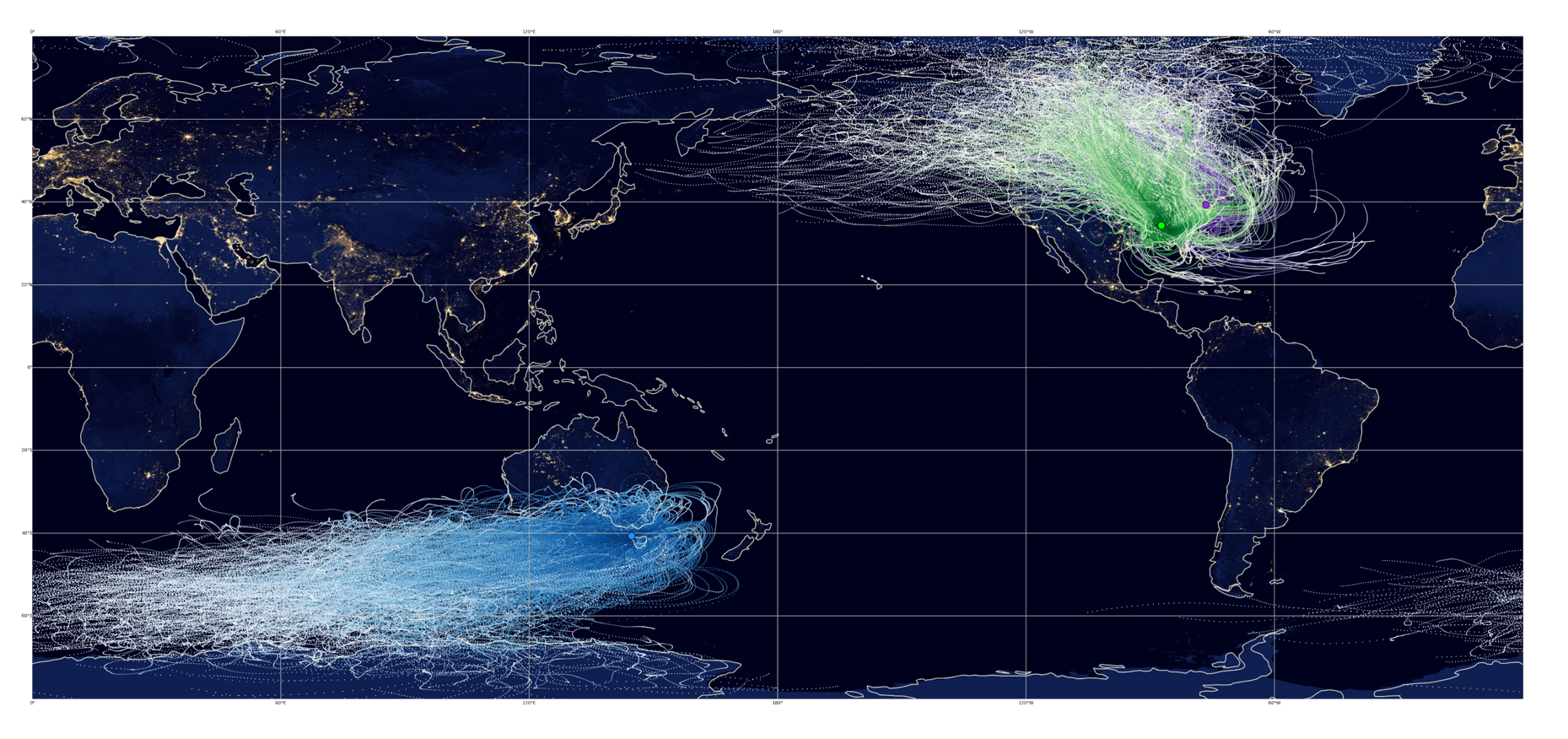
New evaluation data are available from a value-added product (VAP) that provides back and forward trajectories for airmasses over Atmospheric Radiation Measurement (ARM) User Facility sites.
The multipurpose ARM trajectory (ARMTRAJ) VAP has been released in evaluation mode for three ongoing ARM Mobile Facility (AMF) deployments—the Bankhead National Forest (BNF) in Alabama, the Coast-Urban-Rural Atmospheric Gradient Experiment (CoURAGE) in Maryland, and the Cloud And Precipitation Experiment at kennaook (CAPE-k) in Tasmania. In addition, ARMTRAJ evaluation data are available from 2015 to 2025 for ARM’s Eastern North Atlantic (ENA) atmospheric observatory in the Azores.
Also, ARMTRAJ evaluation data have been released for ArcticShark uncrewed aerial system flights in 2023 and 2024 at the Southern Great Plains (SGP) observatory in Oklahoma and tethered balloon system (TBS) flights during the 2021–2022 TRacking Aerosol Convection interactions ExpeRiment (TRACER) in Texas and the 2021–2023 Surface Atmosphere Integrated Field Laboratory (SAIL) campaign in Colorado.
ARMTRAJ can provide information on the likely history of airmasses before they were observed over an ARM site, such as origin and surface interaction. Moreover, back and forward trajectories can suggest that an airmass has passed over other ground-based measurement sites upwind and downwind, respectively. ARMTRAJ data also enable better synthesis of ARM observations with satellite observations and can provide boundary conditions for modeling studies constrained by ARM data.
A Jupyter Notebook demonstrating use of ARMTRAJ data is available on the ARM-Notebooks GitHub repository.
The ARMTRAJ VAP now consists of six trajectory data sets to support atmospheric research using ARM data:
- primary cloud decks (listed as the ARMTRAJARSCL data product in ARM’s Data Discovery portal)
- distinct liquid-bearing cloud layers (ARMTRAJCLD)
- the planetary boundary layer (ARMTRAJPBL)
- surface aerosol (ARMTRAJSFC)
- ARM Aerial Facility (AAF) flight measurements (ARMTRAJAAF)
- ARM TBS flight measurements (ARMTRAJTBS).
Here are the trajectory data sets that are newly available from ARMTRAJ:
- BNF main site: ARMTRAJARSCL, ARMTRAJCLD, ARMTRAJPBL, ARMTRAJSFC
- BNF supplemental sites S20, S30, and S40: ARMTRAJSFC
- CAPE-k ARM Mobile Facility: ARMTRAJARSCL, ARMTRAJCLD, ARMTRAJPBL, ARMTRAJSFC
- CoURAGE main site: ARMTRAJARSCL, ARMTRAJCLD, ARMTRAJPBL, ARMTRAJSFC
- CoURAGE supplemental site S2: ARMTRAJCLD, ARMTRAJPBL
- ENA: ARMTRAJARSCL, ARMTRAJCLD, ARMTRAJPBL, ARMTRAJSFC
- SAIL ARM Mobile Facility and supplemental site S4: ARMTRAJTBS
- SGP: ARMTRAJAAF
- TRACER supplemental site S3: ARMTRAJTBS.
Once the VAP becomes operational, which is estimated to take place in the upcoming month, it is planned to run for past, present, and future AMF, AAF, and TBS deployments as well as ARM’s SGP, ENA, and North Slope of Alaska observatories.
More information on ARMTRAJ is available on the VAP web page, in a recent Earth System Science Data article (Silber et al. 2025), and in an ARM technical report (Silber et al. 2025).
Access the data in the ARM Data Center. (To download the data, first create an ARM account.)
To ask questions, report data issues, or provide feedback to improve this evaluation product before it becomes operational, please contact Israel Silber.
When citing the data, please using the following DOIs:
- ARMTRAJARSCL: doi:10.5439/2309849
- ARMTRAJCLD: doi:10.5439/2309851
- ARMTRAJPBL: doi:10.5439/2309848
- ARMTRAJSFC: doi:10.5439/2309850
- ARMTRAJAAF: doi:10.5439/2473260
- ARMTRAJTBS: doi:10.5439/2530722.
References:
Silber I, J Comstock, M Kieburtz, and L Russell. 2025. “ARMTRAJ: a set of multipurpose trajectory datasets augmenting the Atmospheric Radiation Measurement (ARM) user facility measurements.” Earth System Science Data, 17(1), https://doi.org/10.5194/essd-17-29-2025
Silber I, JM Comstock, MR Kieburtz, KL Gaustad, and F Mei. 2025. ARM Trajectories Data Set Value-Added Product Report. Ed. by Robert Stafford, ARM User Facility. DOE/SC-ARM-TR-314. 10.2172/2498401.
Follow Us:


Keep up with the Atmospheric Observer
Updates on ARM news, events, and opportunities delivered to your inbox
ARM User Profile
ARM welcomes users from all institutions and nations. A free ARM user account is needed to access ARM data.


