

New Calibrated Cloud Radar Data Available for MOSAiC and TRACER Campaigns
Published: 17 June 2025
The Atmospheric Radiation Measurement (ARM) User Facility has released a calibrated version of the Ka-Band ARM Zenith Radar Active Remote Sensing of CLouds value-added product (KAZRARSCL VAP) for the 2019–2020 Multidisciplinary Drifting Observatory for the Study of Arctic Climate (MOSAiC) expedition in the central Arctic and the 2021–2022 TRacking Aerosol Convection interactions ExpeRiment (TRACER) near Houston, Texas.
KAZRARSCL allows scientists to more easily use corrected and calibrated observations, such as reflectivity, from the vertically pointing KAZR and provides access to hydrometeor masks and cloud boundaries for the full lengths of MOSAiC and TRACER.
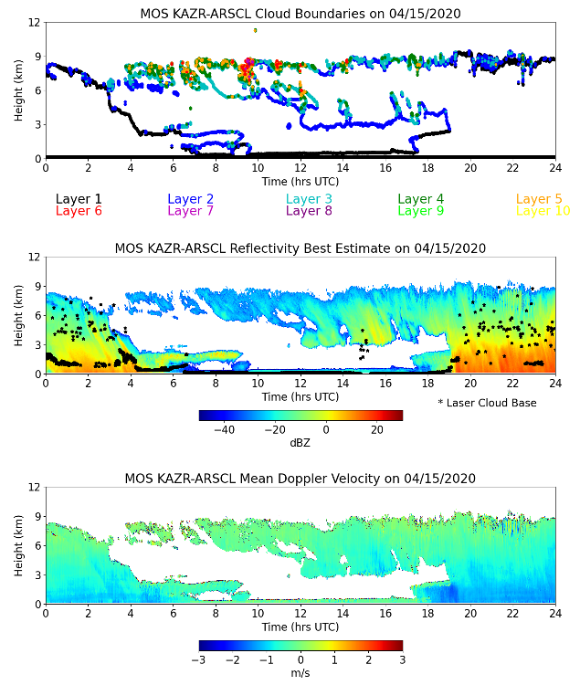
The KAZRARSCL VAP combines KAZR, micropulse lidar, ceilometer, sounding, and microwave radiometer input observations. KAZR reflectivities are corrected for gaseous attenuation, using the Interpolated Sonde (INTERPSONDE) VAP, and for near-field antenna effects. KAZR operating modes are optimally merged to ensure maximum hydrometeor detection. Mean Doppler velocities are dealiased to correct periods in which observed velocities exceeded the radar’s maximum (Nyquist) velocity. Cloud boundaries are determined by combining cloud detections from the KAZR and the Micropulse Lidar Cloud Mask (MPLCMASK) VAP.
KAZRARSCL produces two daily datastreams. The arsclkazr1kollias datastream provides best-estimate radar reflectivities, mean Doppler velocities, spectral widths, and a significant detection mask across time and height. Vertical profiles of these quantities are provided every four seconds from approximately 160 meters above ground level up to 18 kilometers, with 30-meter height resolution. This datastream also provides up to 10 layers of cloud boundaries (cloud base and cloud top) and best-estimate cloud base at the four-second intervals. The smaller arsclkazrbnd1kollias datastream includes only the cloud boundaries and cloud base fields.
The calibrated KAZRARSCL data are c1-level products. When .c1 data are available, they should be used instead of .c0 (uncalibrated) data.
More information about the VAP, including the technical report, can be found on the KAZRARSCL web page.
Scientists can access the new TRACER and MOSAiC KAZRARSCL data now in the ARM Data Center. (To download the data, first create an ARM account.)
To ask questions, provide feedback, or report data issues, please contact developer Karen Johnson or ARM translator Dié Wang.
To cite the KAZRARSCL data, please use doi:10.5439/1228768 for arsclkazr1kollias and doi:10.5439/1228769 for arsclkazrbnd1kollias.
Follow Us:


Keep up with the Atmospheric Observer
Updates on ARM news, events, and opportunities delivered to your inbox
ARM User Profile
ARM welcomes users from all institutions and nations. A free ARM user account is needed to access ARM data.


