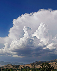
Storm Clouds Take Rain on Rollercoaster Ride
Submitter:
Ovchinnikov, Mikhail — Pacific Northwest National Laboratory
Area of research:
Cloud Processes
Journal Reference:
Science
Most of us think that when rain forms in a cloud, it will instantly fall down. That's what climate models typically assume, too. But in reality, rising plumes that form turbulent storm clouds can often carry raindrops, snowflakes, and even hailstones upward before they fall out. This lengthened journey prolongs their growth stage and boosts the eventual intensity and amount of precipitation. To replicate this roundabout route in climate models, a team of Pacific Northwest National Laboratory researchers found a way to compute the complex fluxes using statistical distributions of the vertical velocity and the kinds of precipitating particles within the convective clouds.
Impact
The researchers demonstrated that an adequate representation of strong precipitating storms in climate models is not possible without an accurate description of rain and snow transport by infrequent and vigorous upward and downdrafts. However, neither convective drafts nor spatial cloud structure are explicitly resolved by coarse-resolution global circulation models, so the convective vertical transport of hydrometeors (all forms of precipitation) must be parameterized.
The researchers showed that by conditionally sampling joint (two-dimensional) distributions of vertical velocity and hydrometeor mass mixing ratios into quadrants, they could obtain the needed hydrometeor fluxes. Then, they scaled the mean quadrant fluxes to account for within-quadrant correlations between vertical velocity and the microphysics.
Developing and evaluating this new approach required detailed knowledge of three-dimensional distributions of vertical motions and cloud properties. Because obtaining this information from observations is not currently possible, the research team conducted a series of high-resolution numerical simulations of summertime convection over the continental United States using supercomputers at the National Energy Research Scientific Computing Center (NERSC) in Oakland, Calif. Then, they harnessed the statistical properties of hundreds of simulated clouds to derive relationships between vertical precipitation fluxes and probability density functions for vertical air velocity and condensate loading.
They finished with a diagnostic evaluation showing that the newly developed representation was successful in reproducing the vertical hydrometeor fluxes.
Summary
To understand convective clouds in climate models, the tall and turbulent storm clouds promising rain, scientists need to describe the strong forces within them. These strong upward and downward drafts can carry precipitation through the cloud before it falls out. It is challenging to include these processes in global models, where the atmosphere is divided into grids much larger than a single cloud occupies. Researchers must turn to formulas to represent these strong drafts and their possible consequences, changing how precipitation is viewed in the model.
By changing the treatment of precipitation, researchers can also improve the model's ability to predict high anvil clouds emanating from the storms. These anvil cloud tops, which form from moisture not harvested by precipitation in tall, convective tower clouds, operate as Earth's thermal blanket and are therefore an important component of the climate system.