Evaluation of Gridded SACR Reflectivity Observations and Vertical Doppler Velocity Retrievals
Submitter:
Lamer, Katia — Brookhaven National Laboratory
Kollias, Pavlos — Stony Brook University
Area of research:
Cloud Distributions/Characterizations
Journal Reference:
Science
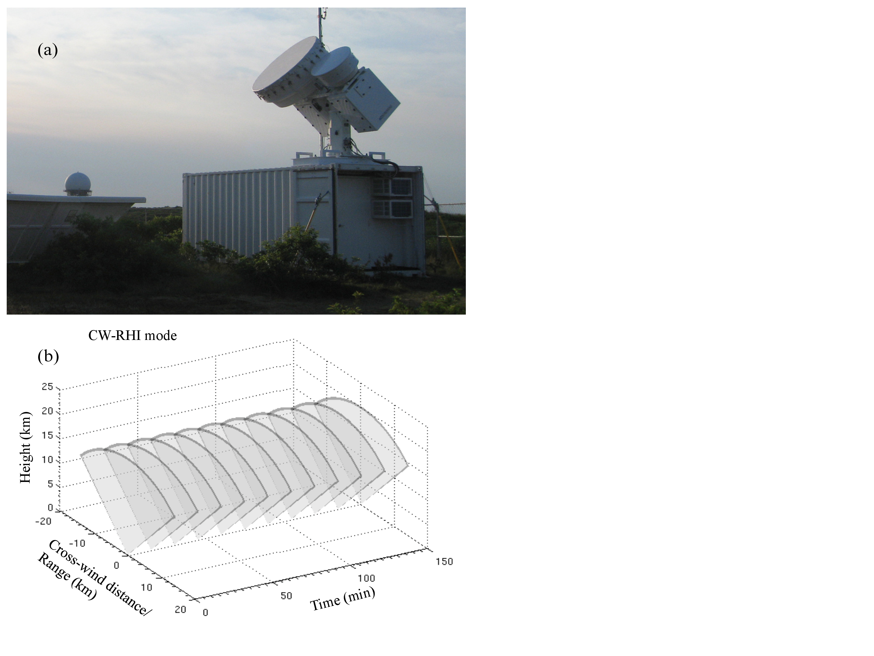
Since the beginning of the ARM program, the bulk of the ARM cloud radar observations have been collected in a zenith-pointing mode (profiling). The lack of volumetric 3D cloud observations hinders our ability to quantify the 3D radiative effects, measure the cloud field anisotropy, study their 3D dynamical structure and monitor their temporal evolution (Kollias et al. 2014a). Recently, the ARM program deployed a number of Scanning ARM Cloud Radars (SACRs). Sampling clouds in 3D is challenging due to their temporal-spatial scales, the need to sample the sky at high elevations and cloud radar limitations. One commonly used scan strategy is to repetitively slice the atmosphere from horizon to horizon as clouds advect over the radar (CW-RHI: Cross-Wind Range Height Indicator, Figure 1).
Impact
The Ka-SACR observations are initially post-processed in their native polar-coordinate system to: 1) detect hydrometeors; 2) correct for gaseous attenuation; 3) remove Doppler velocity folding; and iv) filter out insect echoes in the boundary layer. Subsequently, all CW-RHI polar-coordinate radar observations (one horizon-to-horizon scan) are gridded to a 2-D Cartesian grid. The gridding algorithm accounts for the 2-D beam geometry and identifies, for each grid point, all radar observations within its radius of influence for input to an interpolation scheme. Then, all 2-D gridded radar observations are gridded along the time dimension. The grid domain size and the grid spacing are user dependent. Four different gridding methods are available: maximum value, mean value, Cressman, and Barnes.
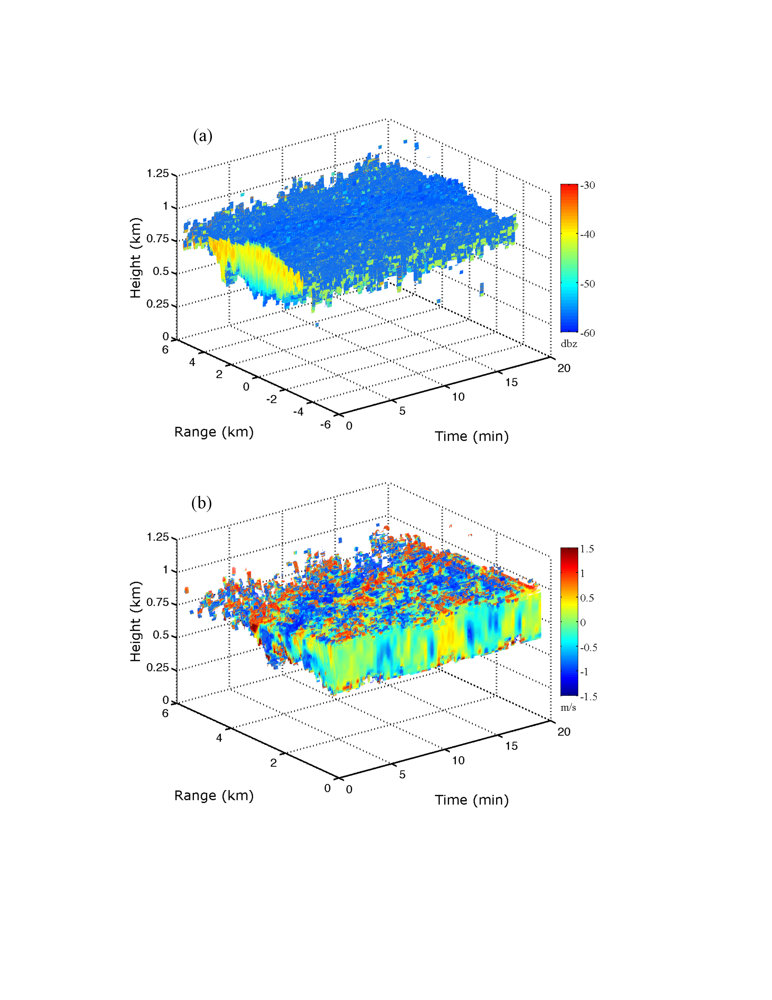
Off-nadir radar Doppler measurements critically depend on the projection of the horizontal wind to the radar line-of-sight. Thus, the observed Ka-SACR Doppler velocities are decomposed to the contribution of the projected-to-the-scan plane horizontal wind and the contribution of the vertical Doppler velocity projected to the radar line of sight. The decomposition technique is applied independently to the 3-D gridded Doppler range-height velocity fields. Independently, at each height, the Doppler velocity measurements at angles 30° to 75° and 105° to 150° are used to estimate horizontal wind and its gradient (if any) along the scan plane. The Doppler measurements at elevation angles 75° to 105° are used to estimate the mean Doppler velocity offset due to particle sedimentation. Finally, the contribution of the horizontal wind is removed and the residual Doppler velocities are corrected for radar centricity (divided with the sine of the elevation angle) to retrieve a best estimate of the vertical Doppler velocity component.
For validation purposes, all gridded and retrieved fields are compared to collocated zenith-pointing ARM cloud radar measurements.
The SACR sensitivity loss with range, the cloud type observed, and the research purpose should be considered in determining the gridded domain size. For a radar sensitivity of -40 dBZ or better, most stratocumulus clouds are detected. However, as the radar sensitivity degrades, their cloud fraction decreases by ~8% per 1 dBZ drop in sensitivity. Drizzling clouds have higher reflectivities. Thus, their cloud fraction is more resilient to changes in radar sensitivity. Since the selection of a radar reflectivity threshold determines the maximum range, this sensitivity is achievable for the Ka-SACR, and this approach could lead to variable domain of 3D gridded products.
The Cressman and Barnes schemes produce very similar results. The possibility of a hybrid scheme that uses Cressman or Barnes everywhere except near the cloud edges is considered. Near-cloud edges, the maximum value interpolation method, performs best since the quality of the radar observables strongly depend on signal-to-noise conditions.
The application of the vertical velocity retrieval technique is applicable to cloud systems that do not alter the environmental wind flow in any significant way (e.g., deep convective clouds) and requires having hydrometeor detections at a particular height on each side of the radar and over a range of elevation angles to minimize the uncertainty in the retrieved horizontal wind. It is established that the CW-RHI observations complemented with processing techniques could lead to robust 3D clouds dynamical representations up to 25-30°off zenith.
Comparisons of the time-height composite generated by extracting the vertically pointing beams of the Ka-SACR, with the time-height composites from the dedicated profiling cloud radars at the ARM sites, clearly indicates that the Ka-SACR is able to resolve all important structures of low and high stratiform clouds.
Summary
Future work will focus on extending the technique to other SACR scan strategies such as Boundary Layer RHI and Hemispherical Sky RHI.