Ground Stations Likely Get a Boost from Satellites to Estimate Carbon Dioxide Emissions
Submitter:
Roeder, Lynne R — Pacific Northwest National Laboratory
Area of research:
Surface Properties
Journal Reference:
Science
Nations around the world are building monitoring systems to track levels of carbon dioxide, one of the greenhouse gases associated with global climate change. The idea is to locate and estimate the magnitude of both the sources of the gas as well as the sinks—places such as oceans and jungles that naturally pull carbon dioxide out of the air and store it for a few months or even hundreds of years.
Impact
Currently, a robust way to estimate carbon dioxide sources and sinks is to measure variations in its atmospheric concentration at a network of ground-based monitoring stations. This network is thin in many parts of the world, such as the Amazon basin and the oceans, both of which play major roles in regulating the amount of the gas in the atmosphere. While atmospheric data gathered from satellites could provide the much-needed coverage, scientists struggle to find ways to trace that information back to the sources and sinks on the ground.
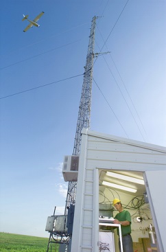
A study recently reported in Atmospheric Chemistry and Physics outlined an approach that could allow scientists to make better use of satellite data for carbon monitoring. The international team of researchers used a series of calculations to combine data from the Greenhouse Gases Observing Satellite (GOSAT) over an 18-month period with nearly 17,000 surface-level observations from 132 locations during the same period. One of these locations was the U.S. Department of Energy’s Atmospheric Radiation Measurement (ARM) Climate Research Facility in Oklahoma. At this site, referred to as the Southern Great Plains site, air samples are collected from a 60-meter tower as part of ARM’s Carbon Project.
Summary
The data from this site, as well as the other ground-based stations and the satellite, allowed the team to estimate the sources and sinks of carbon dioxide around the world. Their results over global scales compared favorably to independent estimates made by government agencies, while at regional scales some differences raised questions for future exploration.
“Using observations from both satellites and surface networks proved more beneficial than using either type of observation alone,” said Sourish Basu, who led the team when he was a researcher at the Netherlands Institute for Space Research. “Satellite-based measurements, however, come with their own unique challenges, and as we get better at tackling those, we will improve our ability to estimate changes in greenhouse gas emissions from satellite-based measurements.”