Tropical Rain Clouds Still a Challenge to Cloud-Resolving Models
Submitter:
Fridlind, Ann M. — NASA - Goddard Institute for Space Studies
Ackerman, Andrew — NASA - Goddard Institute for Space Studies
Area of research:
Cloud Distributions/Characterizations
Journal Reference:
Science
Tropical clouds and precipitation are a key component of the Earth's climate system and therefore critical to simulate faithfully in climate models. However, even the most detailed cloud-resolving models (CRMs) have difficulty representing the complex array of processes and scales that occur in tropical storms, including wind patterns, cloud particles, rain, and ice, in part because many key processes are not well understood and in part because the complexity is difficult to represent (such as the variety of ice particle properties). In this study, eight CRMs from institutions in the USA, UK, and France are used to simulate two weeks of active and suppressed monsoon conditions observed around the Department of Energy’s ARM Climate Research Faciilty measurement site at Darwin, Australia. This is the first CRM intercomparison that included an observed aerosol size distribution profile based on observations. The aerosol profile was used in five simulations from three independent CRMs that included two-moment microphysics, while the remaining simulations assumed fixed droplet number concentrations.
Impact
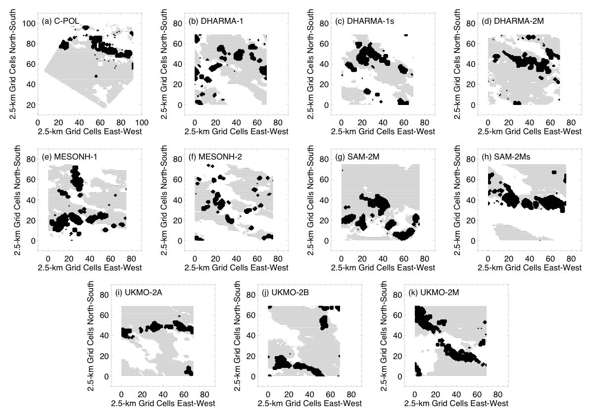
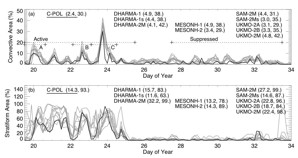
A unique aspect of this study is the effort to evaluate the overall structure of CRM-simulated cloud systems. To do this, a technique used by radar meteorologists to identify the heavily raining updraft regions (so-called convective areas) and less violent and lighter-raining broad regions (so-called stratiform areas) was applied in an identical fashion to both observations and simulations. Since observations used radar measurements centered at a height of 2.5 km above the surface (where the radar can view long distances) and at a horizontal resolution of 2.5 km, radar reflectivity was calculated from the simulated rain fields at the same elevation and resolution (averaging down the model resolutions of ~1 km). This allowed direct comparison of convective and stratiform cloud features in observations and simulations (Figure 1). It was found that convective areas were quite similar to the observations in terms of timing, but the regions were always larger than observed in every simulation, by more than observational uncertainty could explain. Stratiform areas were far more variable in timing and extent (Figure 2). Here the stratiform area definition is important, and we used a definition that revealed a strong anticorrelation between the so-defined stratiform area and outgoing longwave radiation (OLR), and a correlation as well between daytime stratiform area and reflected solar radiation.
Summary
The wide spreads of predicted stratiform cloud properties and their close association with radiative fluxes, which are important to climate in the tropics, indicate that there is a need for more rigorous observationally based evaluation of the underlying properties of stratiform rain structures in simulations. Are the stratiform ice properties realistic? In addition, since stratiform areas are injected with outflow from convective areas, their properties also warrant further study. The properties of ice originating in convective regions may be a greater determining factor than the processes that modulate the subsequent evolution of the ice in stratiform regions.