

The Mystery of Missing Water From Mountain Sources
Published: 20 April 2023
An ARM-assisted project at the University of Washington leverages a rare confluence of collaborators to study snow sublimation
On the westward side of the Rocky Mountains, the Upper Colorado River Basin has historically been a wintertime storage bin for snowpack, the compressed remnants of months of falling snow. As the snowpack melts, the resulting runoff joins water sources from other mountain watersheds and fills the coffers of streams and rivers fanning out into the Western United States.
About 40 million Americans in seven states depend on that water for drinking, hydropower, and agriculture.
But there’s a catch.
Not all the snowpack melts to become usable water. In the spring of 2021, for example, snowpack in this mountain reservoir of the Colorado River measured at about 80% of historical averages. But the water that flowed out of the basin was only about 25% of what was expected.
Available snow-to-water amounts “fell off a cliff,” says Daniel Feldman, a researcher from Lawrence Berkeley National Laboratory in California. Feldman leads a 21-month investigation of mountain hydrology called the Surface Atmosphere Integrated Field Laboratory (SAIL) campaign, slated to wrap up in June 2023.
The Atmospheric Radiation Measurement (ARM) user facility is conducting SAIL operations in Colorado. For a shade over 30 years, ARM, a U.S. Department of Energy (DOE) scientific user facility, has collected continuous atmospheric data using fixed-location and mobile observatories worldwide.
SAIL’s area of inquiry is the Upper Colorado River Basin, where scientists are studying subsurface, surface, and atmospheric conditions.
Mountain hydrology involves a deeply complex array of interactions: of groundwater, soil moisture, surface runoff, streams, vegetation, the rise and fall of terrain, wind patterns, and the whole panoply of atmospheric factors that release and control moisture and fluxes of energy.
Puzzled by the spring of 2021’s missing water, Feldman identified one suspect as snow sublimation. During this common but hard-to-study physical transformation, a substance passes directly from a solid to a gas, bypassing the intermediate liquid state. In the case of snow, some of the potential water stored in ice vanishes into the atmosphere as a vapor.
An SOS for Missing Snow
Little is known about exactly how snow sublimation happens. That’s especially true in mountainous terrain, where the necessary subsurface-to-atmosphere observations are difficult, or even hazardous, to obtain.
Taking on this challenge is the Sublimation of Snow (SOS) project, led by Jessica D. Lundquist, a snow hydrologist at the University of Washington (UW). SOS research partners include NOAA and DOE.
The stakes of knowing more are high. Rates of water loss from high-terrain snow sublimation vary widely but can reach up to 90%.
That said, “estimating future streamflow from snow on the ground is way more predictable than estimating the upcoming weather (and rainfall) over the next three months,” says Lundquist. “It’s just that people get used to snow being a good predictor―and when it’s not, they get really upset.”
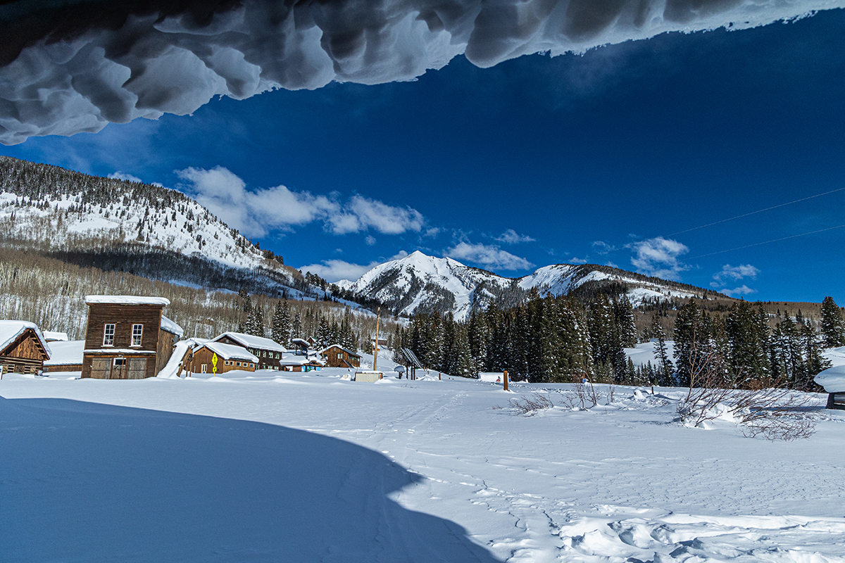
SOS, funded by the National Science Foundation, is one of SAIL’s sister campaigns. It got underway in October 2022, when Lundquist and others set up an elaborate array of instruments in a mountain meadow called Kettle Ponds, just south of Gothic, Colorado. The onetime silver-mining town is in the shadow of the West Elk Mountains.
Kettle Ponds is near the venerable Rocky Mountain Biological Laboratory (RMBL), where most SAIL instruments are deployed.
From its onset, in September 2021, SAIL’s elaborate system of instruments and collaborators lacked just one thing: a way to investigate snow sublimation. Now it has one, thanks to Lundquist, her collaborators, and her research group.
Both SAIL and SOS come at a critical time. Model projections suggest that the Western United States will experience regular low-to-no snow winters in 35 to 60 years if warming trends continue and snowpack continues to decline.
One Day in 2021 …
During her doctoral studies at the University of California San Diego’s Scripps Institution of Oceanography, Lundquist researched the links between diurnal cycles and snowpack, and the onset of synchronous springs in the Sierra Nevada, when snow starts melting at all elevations at once.
Years later, what led her to propose—and now execute—the SOS project? Two chance occurrences on one day in the spring of 2021.
First, UW’s media office called Lundquist to ask for her thoughts as UW’s expert on snow. It was during a time when low-producing snowpack was in the news.
Reporters asked: Where is the missing water going? Is snow sublimation to blame? That was one of three main hypotheses on where meltwater was going. The others: It disappeared into soil, where plants released the water to the atmosphere through transpiration, or it disappeared into groundwater.
Snow sublimation “is a wicked-hard problem to measure,” says Lundquist, who was dissatisfied with the answers she could offer reporters and downstream water stakeholders.
On the same day Lundquist started fielding media inquiries, she got a phone call mentioning Feldman’s plans for SAIL. A collaboration light bulb went off in her head. Why not design a study on snow sublimation, one that would leverage SAIL’s instruments and partners?
Lundquist read the literature on previous investigations into snow sublimation. Papers turned up regarding snow sublimation in places such as the Tibetan Plateau, India, Chile, Antarctica, China, and the Swiss Alps. She also referenced a 2018 review paper on snow-cover dynamics by Rebecca Mott-Grünewald of the WSL Institute for Snow and Avalanche Research (SLF) in Davos, Switzerland. (SLF is now an SOS research partner.)
In addition, two recent experiments led Lundquist to look for “what worked and what didn’t,” she says, acknowledging debts to previous researchers. “We’re building on their expertise.”
In one, scientists deployed 12 sonic anemometers to measure wind speed and direction on a glacier in Switzerland. In another, researchers set up single instrumented towers at three sites in Colorado.
Both experiments focused primarily on atmospheric properties, says Lundquist, but neither adequately measured how complex surface conditions can get in mountainous terrain, especially when “the snow itself changes all winter long.”
Below, At, and Above the Surface

Lundquist’s study design pivoted on the uniqueness of mountainous terrain, the need for more instrumentation than previous studies, and the need to be onsite for a whole snow season.
The first official SOS measurements came in November 2022. SOS will continue until June 1, 2023―two weeks before SAIL ends and around the time most snow near Gothic reliably disappears.
The instrument footprint is 5,000 square feet, or slightly bigger than a full-sized basketball court used for professional play.
The basic shape of the site is a triangle of three instrumented 10-meter (33-foot) towers, with a 20-meter (66-foot) tower in the middle.
The site has four flat “snow pillows,” 3 by 3 meters square (about 10 feet to a side), designed to measure snowpack by weighing water content.
Much of the gear is borrowed from the Earth Observing Laboratory at the National Center for Atmospheric Research (NCAR) in Colorado.
The heart of what Lundquist calls the site’s “extreme number of sensors” is NCAR’s Integrated Surface Flux System, which supports “micrometeorological” research campaigns―those that measure atmospheric phenomena right above the surface, at scales that are local and small.
She credits a team of scientists and engineers led by NCAR’s Steven Oncley and Chris Roden for making her triangular site design a reality.
A 3-Dimensional Map of Blowing Snow
In all, more than 100 instruments are arrayed throughout the SOS site. They are below the surface, measuring soil moisture and temperature; at the surface; and up to more than 60 feet above the surface.
NCAR personnel visit the site once a month, skiing in to check and fix instruments.
“The real investment is in the engineers,” says Lundquist.
NCAR hydrometeorologist Ethan Gutmann deployed six lidars at the site, two on each 10-meter tower. Four are still operating, he says.
Lidars use radar-like pulses of laser beams to scan the study area, giving researchers “a 3D map of the changing surface,” says Lundquist.
The lidars add to a dynamic local portrait of falling, blowing snow and eccentric winds.
In addition, there is a snowflake camera at the SOS site, deployed by Aaron Kennedy, a scholar of blowing snow at the University of North Dakota. The camera snaps approximately 30 frames per second.
Collaborators from SLF will return to the site in the spring to get images of turbulent fluxes over patchy melting snow.
Lundquist says a thermal infrared camera—borrowed from her by the Swiss researchers—creates images of temperatures mixing across the surface, a stochastic display of seeming chaos, and sometimes “snow blowing around and dancing with the turbulence.”
Vertical rods at the site measure the impact of blowing snow bouncing along the surface in a sifting, shifting phenomenon called saltation.
Other instruments on the towers capture temperature and humidity data in 1-meter (3-foot) increments, from the snow surface to the tower top. Sonic anemometers and hydrometers collect continuous measurements of high-speed energy fluxes and “water vapor pulsing into the atmosphere,” says Lundquist.
The Longest, Best Look
Besides RMBL, SOS has a second solid local partner: the Aspen Global Change Institute (AGCI) in Colorado. Lundquist, Gutmann, and AGCI Research Director Julie Vano assembled the SOS proposal. Vano is a co-principal investigator for SOS.
To date, says Lundquist, SOS is the longest, best-instrumented investigation of snow sublimation, the likely main culprit of missing mountain snow.
“This will be the first data set to constrain the one thing models (of snow sublimation) diverge on, by a factor of two or three,” she says of data gathered for SOS, which are published in real time.
In the end, SOS may deliver the kind of all-season, comprehensive data needed to improve predictive models of water delivered by mountain hydrological systems.
Lundquist says SOS adds observations where there have been none or few. She also calls the project a practice run for observational techniques that will have value in other snow-atmosphere field campaigns.
There are global implications.
Mountains are often called “the water towers of the world” for their large contributions to freshwater resources. In the 40% of mountain regions with snowpack, these water towers deliver from 60% to 90% of the water that goes into streams, rivers, and recharged groundwater.
SAIL Instruments at Work
SAIL instruments, says Lundquist, “are absolutely critical” in supplementing the SOS attempt to record conditions in complex mountainous terrain, something that has long been familiar to ARM.
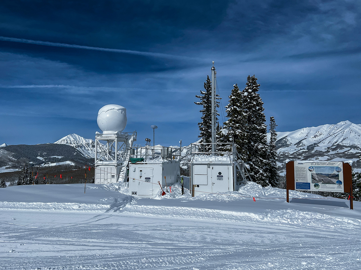
Critically, a nearby X-band scanning radar and Doppler lidar capture a picture of wind fields and turbulence generated from above, in the upper part of the atmospheric boundary layer. The X-band radar is at the top of Crested Butte Mountain Resort, overlooking Kettle Ponds, and the Doppler lidar is in the town of Gothic.
SOS instruments supply complementary data gathered in the lower boundary layer at a micrometeorological scale. SOS creates a framework of data on snow and jittery winds within its 5,000-square-foot study area; SAIL encloses that framework with a roof of data.
Gothic Mountain, which towers over Gothic, controls local wind patterns in a unique way, says Lundquist, generating cloud-size dispersals of snow and “breaking waves of turbulent mixing you can see with the lidar.”
SOS data include measurements collected during a two-week intensive operational period in January 2023.
Lundquist says she would have stayed five times longer if she could have. There are paths of knowledge beyond data, she argues, including an immersion in the locale of research.
“The thing that struck me most was the blowing snow,” says Lundquist. “You have to be there.”
Snow blew off Gothic Mountain in cloud-like billows, and “ground snow lofted into the air,” she says. “It was mesmerizing.”
The Snow Brothers
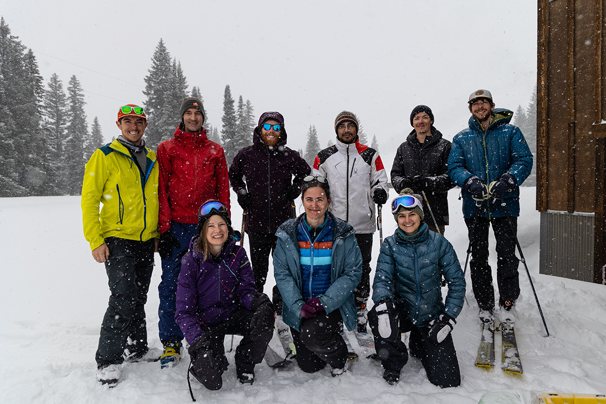
With direction from Lundquist, two of her PhD students did get to spend extra time at the SOS site. Daniel “Danny” Hogan and Eli Schwat spent 10 weeks from January through mid-March 2023 immersed in the realities of snow in Gothic.
“They lived on skis,” says Lundquist, enviously.
True, says Hogan, who composed an email narrative of the time the two snow brothers spent in and around SOS.
Coffee, breakfast (they both cook), and computer work in the morning. A look at weather conditions. Then exit their RMBL cabin (no indoor bathroom, but warm enough) to ski to the SOS site just over a mile away. Commute time: 30 minutes, says Hogan, “if conditions were good,” meaning free of “fresh snow and strong winds.”
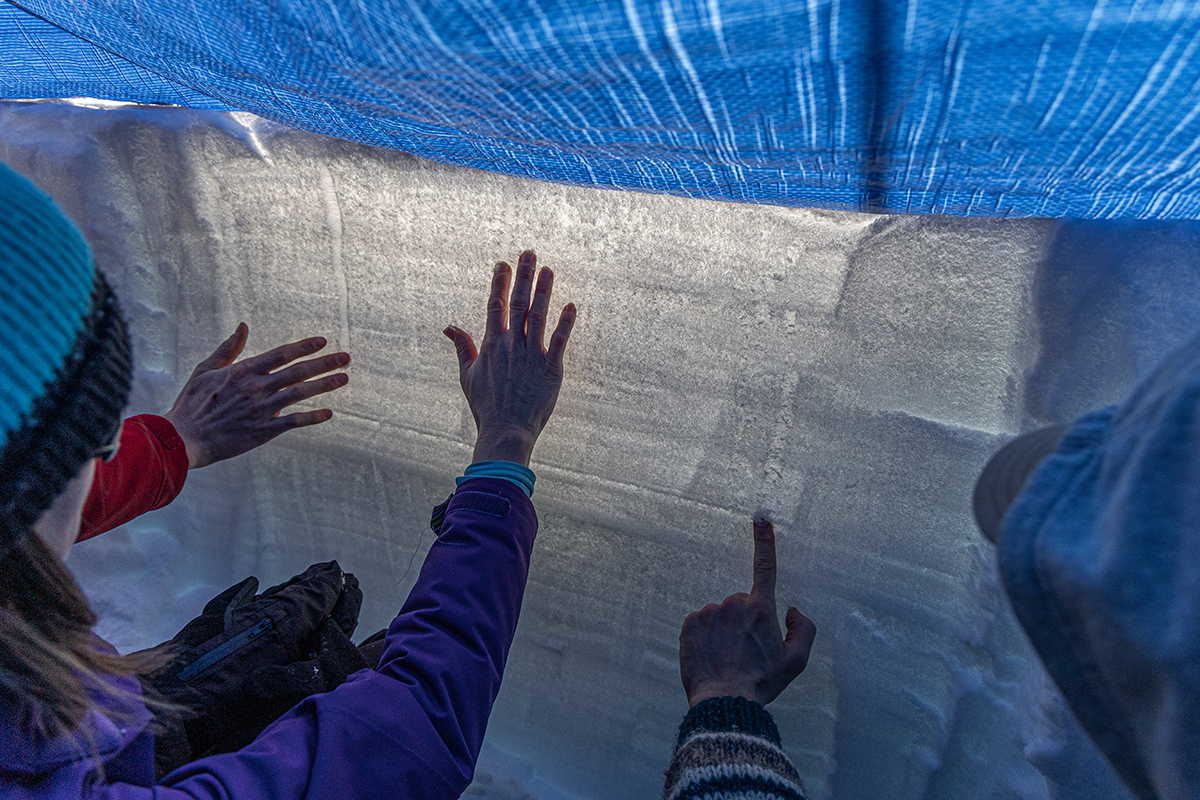
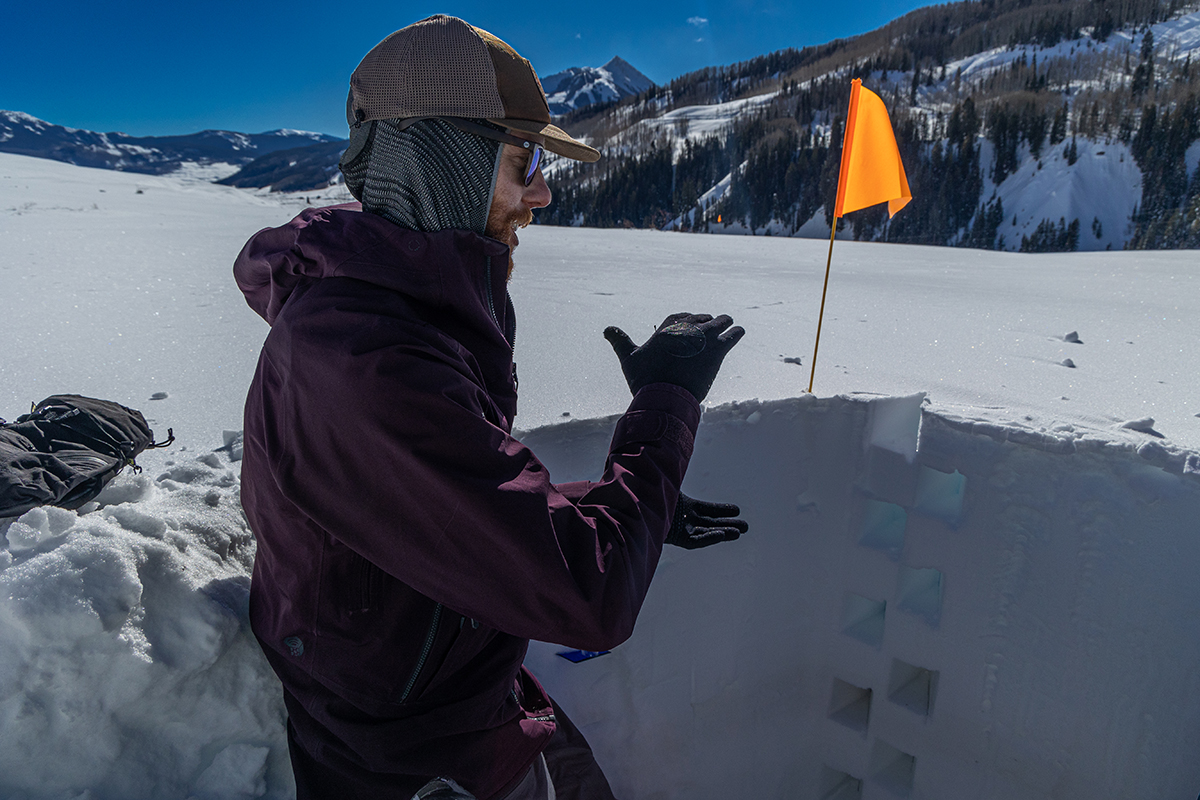
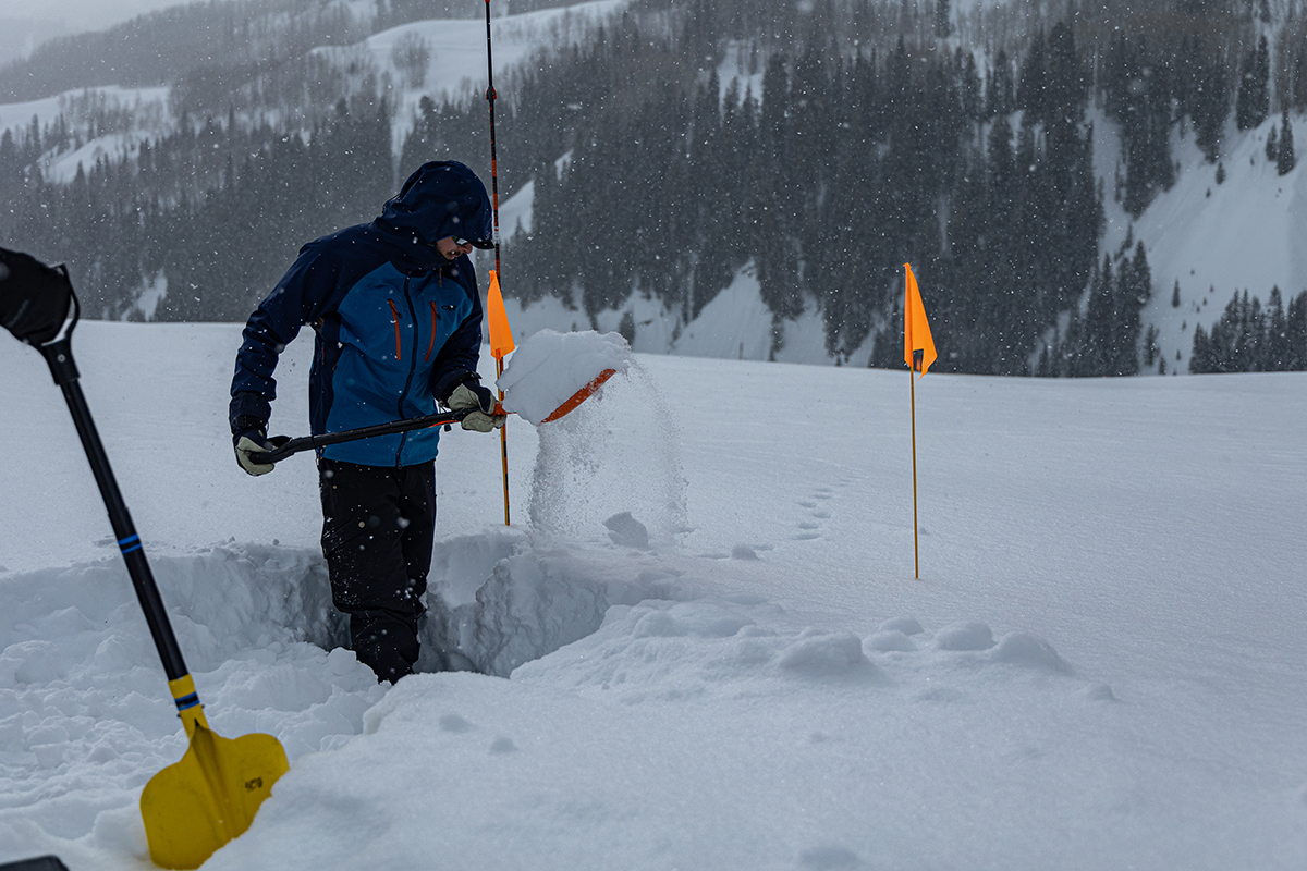
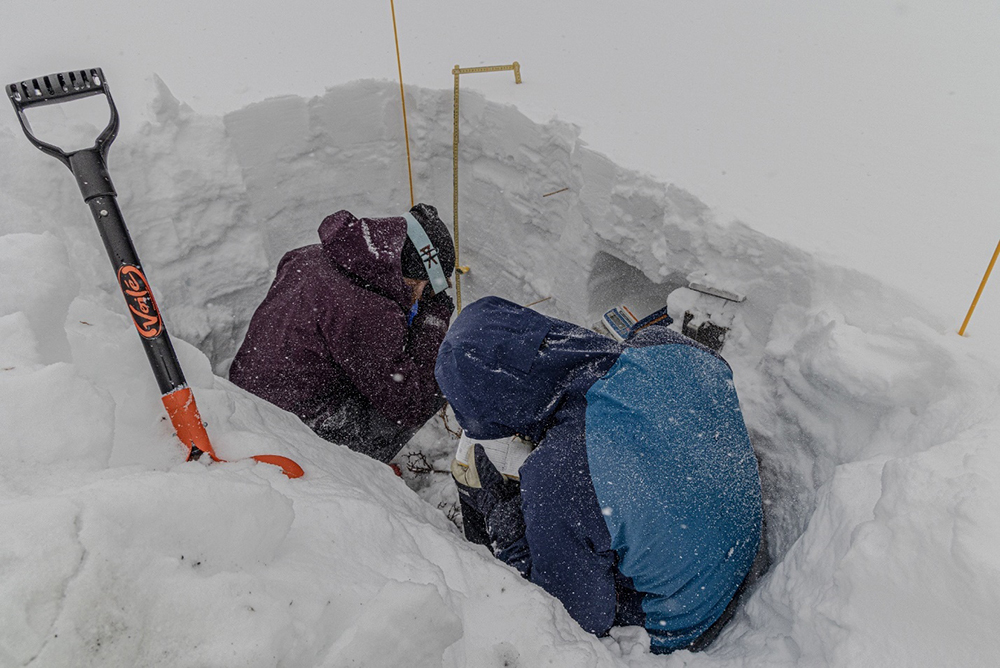
At the site, there was a rotating division of labor: One cleaned snow off instruments, and one began to dig the day’s snow pit. These deep, shoveled-out rectangles, about the size of a hot tub, allowed them to take subsurface measurements of snowpack properties.
Some snow pits are dug side by side, leaving a thin, translucent, easy-to-examine panel of snowpack layers in between.
Taking measurements required packing in some science gear. Hogan and Schwat carried a scale for weighing snow to calculate snow density; a thermometer to record temperatures at different levels of the exposed snowpack, which Lundquist likened to layers of sedimentary rock; rulers; a magnifying glass to peer at snow crystals, which vary as temperature and porosity change; and an infrared thermometer to capture surface temperatures.
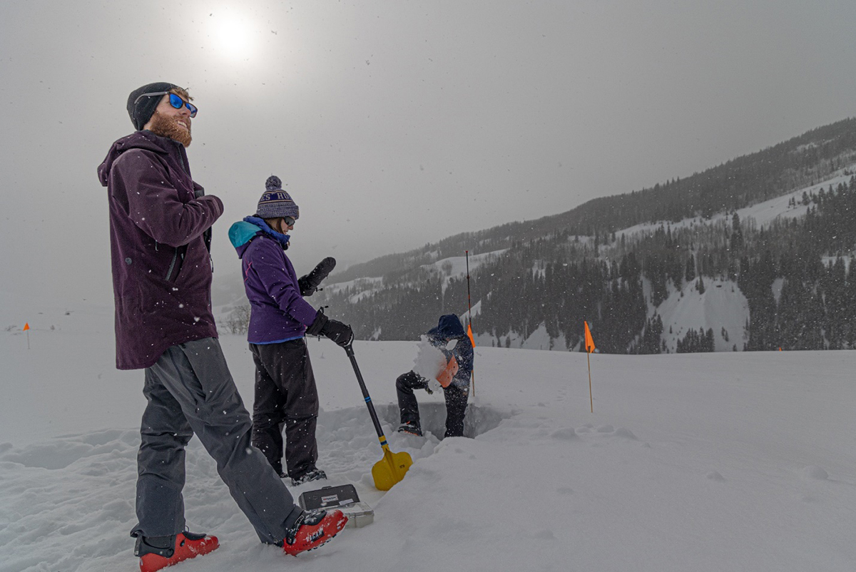
Ski, clean, dig, measure. The two graduate students, who by lunchtime were catching up on personal projects back at the cabin, rolled through this two-hour site routine five or six days a week.
Every week, “we took one or two days to ourselves with some work thrown in,” says Hogan, “along with ample amounts of skiing around to explore the beautiful East River basin.”
Every couple of weeks, Hogan and Schwat skied to the trailhead at Mount Crested Butte, a small town 4 miles away, then drove 2 miles more to restock the cabin pantry in the larger town of Crested Butte. What they could not carry back was delivered via snowmobile.
AGCI Climate Science Fellow Emilio Mateo visited occasionally, his camera at the ready.
The Hogan-Schwat social circle also included technicians from the SAIL site, RMBL caretakers, and billy barr, who in 1973 became Gothic’s first full-time resident. A colorful hermit, he has since been a fixture at RMBL and is famous now for his five decades of records on snow levels, wildlife, and other environmental data.
The Next Steps
“If there is a take-home message, it is how valuable it is for everyone to collaborate. (SOS) is an amazing example of multi-agency cooperation (where) everyone is working to make science open and accessible.”
Jessica Lundquist, SOS principal investigator
Lundquist is preparing for the next phase of SOS―analyzing an unprecedented snow sublimation data set, as well as complementary measurements from SAIL’s other sister campaigns.
“If there is a take-home message,” she says, “it is how valuable it is for everyone to collaborate. (SOS) is an amazing example of multi-agency cooperation (where) everyone is working to make science open and accessible.”
To make the transition from observations to analysis easier, Lundquist is teaching a spring 2023 graduate course on snow hydrology, with SOS as the main focus. She calls it “a work in progress” and a “beta version” of what she hopes will be a continuing spring-quarter course.
The class also illustrates SOS outreach efforts―a steady stream of videos, blogs, open-source Python notebooks, interviews, and other resources to help educate wide-ranging audiences, from children to PhDs to science forums, on the mysteries of snow sublimation.
Mateo, AGCI Community Science Manager Elise Osenga, and AGCI Communications Manager Liz Carver are a big part of SOS outreach, which they hope will create among scientists a group of what Mateo calls “snow sublimation ambassadors.”
Lundquist has another kind of outreach ahead of her in June 2023, when she will be one of just eight invited speakers at the 36th International Conference on Alpine Meteorology in St. Gallen, Switzerland.
Her talk seems right on the mark. It’s titled, “Where does mountain water go?”
Follow Us:


Keep up with the Atmospheric Observer
Updates on ARM news, events, and opportunities delivered to your inbox
ARM User Profile
ARM welcomes users from all institutions and nations. A free ARM user account is needed to access ARM data.


