

SHEBA: Still Serving Science
Published: 19 October 2019
An arctic field campaign in the late 1990s set the stage for present-day research investigating shrinking ice cover, warming temperatures, and other changes
In May 1998, Bonnie Light, then a graduate student in atmospheric science at the University of Washington, climbed into a Twin Otter aircraft at an airfield in northern Alaska. It was the first step in a flight over an ice-covered arm of the Arctic Ocean called the Chukchi Sea.
Soon she was gazing at the lead edge of a perennial sea-ice canopy that at the time, in winter, covered about 80 percent of the Arctic Ocean.
“It was the first time I had really seen real sea ice,” says Light, now at the university’s Applied Physics Laboratory. “To see it was real. I was looking at an area of the planet that matters so much.”
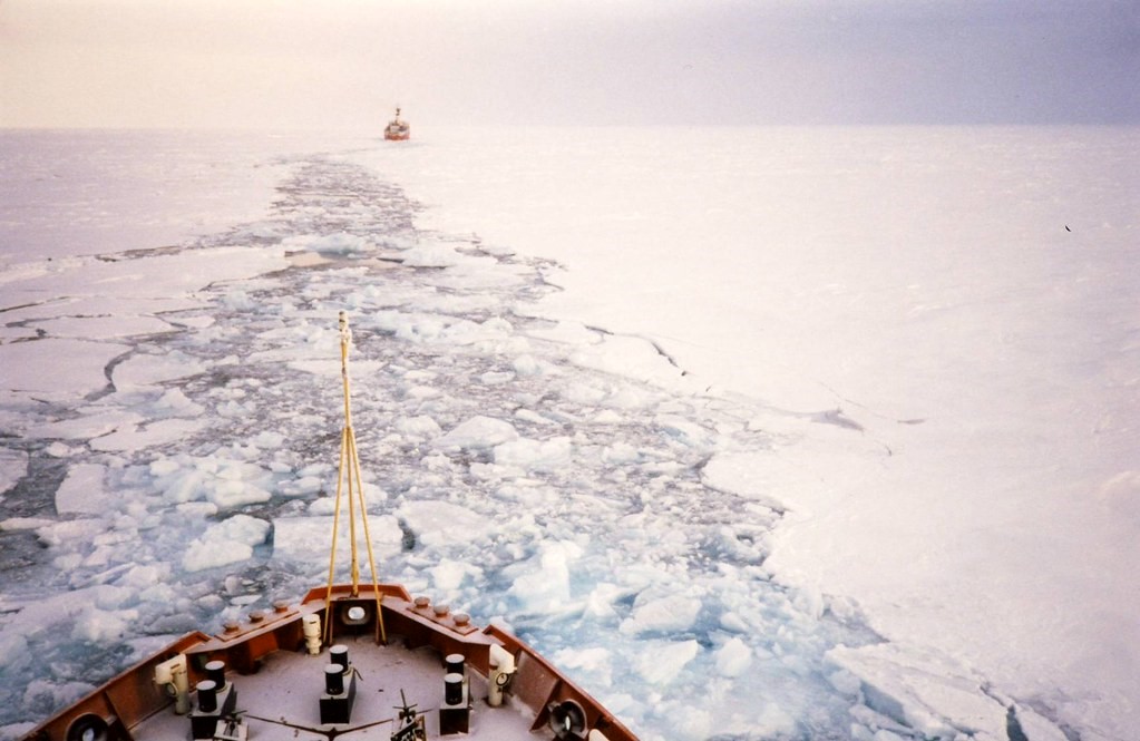
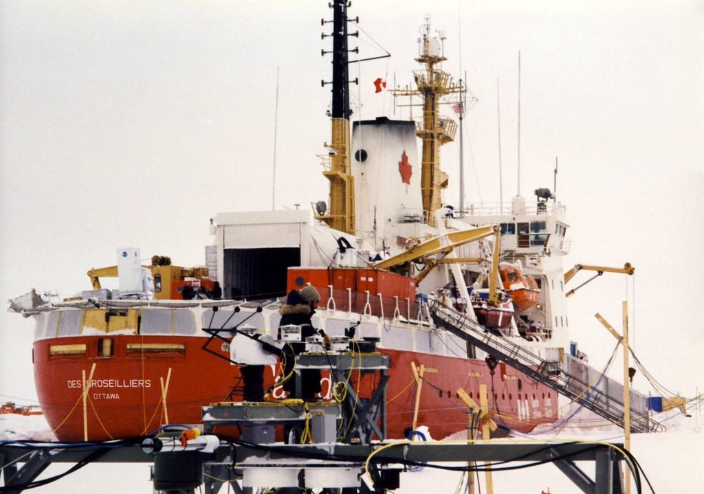
The Twin Otter headed to an ice camp alongside the Canadian Coast Guard icebreaker Des Groseilliers, which was home, haven, and laboratory for the Surface Heat Budget of the Arctic Ocean (SHEBA) field campaign.
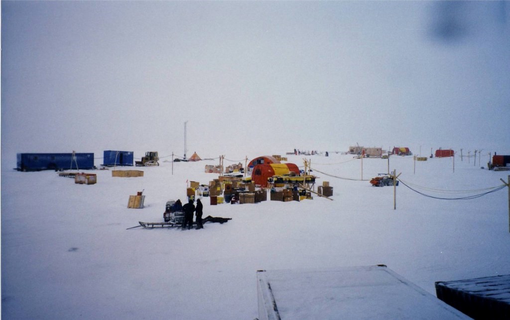
Twenty-two years ago, researchers deliberately embedded the ship into an ice pack a few hundred miles northeast of Prudhoe Bay, Alaska. Starting in September 1997, the ship, researchers, and Montreal-based crew spent a year and nine days fruitfully scouting one of the most poorly observed regions in the world. About 200 scientists took part, shuttling on and off the ice in all seasons.
The icebound Des Groseilliers drifted up to 16 kilometers (10 miles) a day, and sometimes as little as a few hundred meters. To help close knowledge gaps in arctic science, SHEBA instruments soaked up data on conditions in the atmosphere, on the ice, and in the ocean.
Support for SHEBA came primarily from the National Science Foundation (NSF) and the Office of Naval Research. Onboard gear included critical instruments from the U.S. Department of Energy’s Atmospheric Radiation Measurement (ARM) program, which later became the ARM user facility.
ARM’s participation in SHEBA provided important experience and insight to the new program as ARM began developing its long-term measurement sites.
The Mission
SHEBA’s interdisciplinary mission was to investigate the atmosphere-ice-ocean system to measure ice-albedo and cloud-radiation feedbacks, and―ultimately―to improve predictive models in a region of increasing temperatures, shrinking sea ice, and amplified effects from earth system change.
SHEBA observations were taken from within an imaginary cylinder, or column, which stretched from the top of the atmosphere down though drifting snow and meter-thick ice into the first 100 meters (328 feet) of the ocean. Supplementary data came from research aircraft, helicopters, and submarines.
“We decided to measure everything we could in the SHEBA column for a whole year,” says the campaign’s chief scientist, Donald Perovich, a sea-ice geophysicist then with the U.S. Army Cold Regions Research and Engineering Laboratory. Now at Dartmouth College, he calls Des Groseilliers―part hotel, part power station and observatory―“Ice Station SHEBA.”
Instruments measured how ice grew and how it absorbed sunlight, the temperature and salinity structure of the ocean, and dozens of other parameters. Those parameters included cloud properties, turbulent fluxes, albedo, ice mass balance, and the ocean’s momentum and heat flux.
ARM’s radiation suite of instruments aboard Des Groseilliers “gave us incredibly valuable information about radiation fluxes,” says Perovich.
Adding to that information was a millimeter wavelength cloud radar then deployed by the National Oceanic and Atmospheric Administration (NOAA) and funded by NSF. ARM provided the seatainer in which the radar was installed, but similar cloud radars went on to become fundamental instruments for the ARM sites.
ARM measurements are still available from SHEBA, including 10 data sets on vertical profiles of clouds and aerosols (tiny particles in the air) within the column.
The Legacy
For Light, who is affiliated with the University of Washington’s Polar Science Center, SHEBA remains an indelible scientific experience.
“I’m still asking questions about things I saw that summer,” she says.
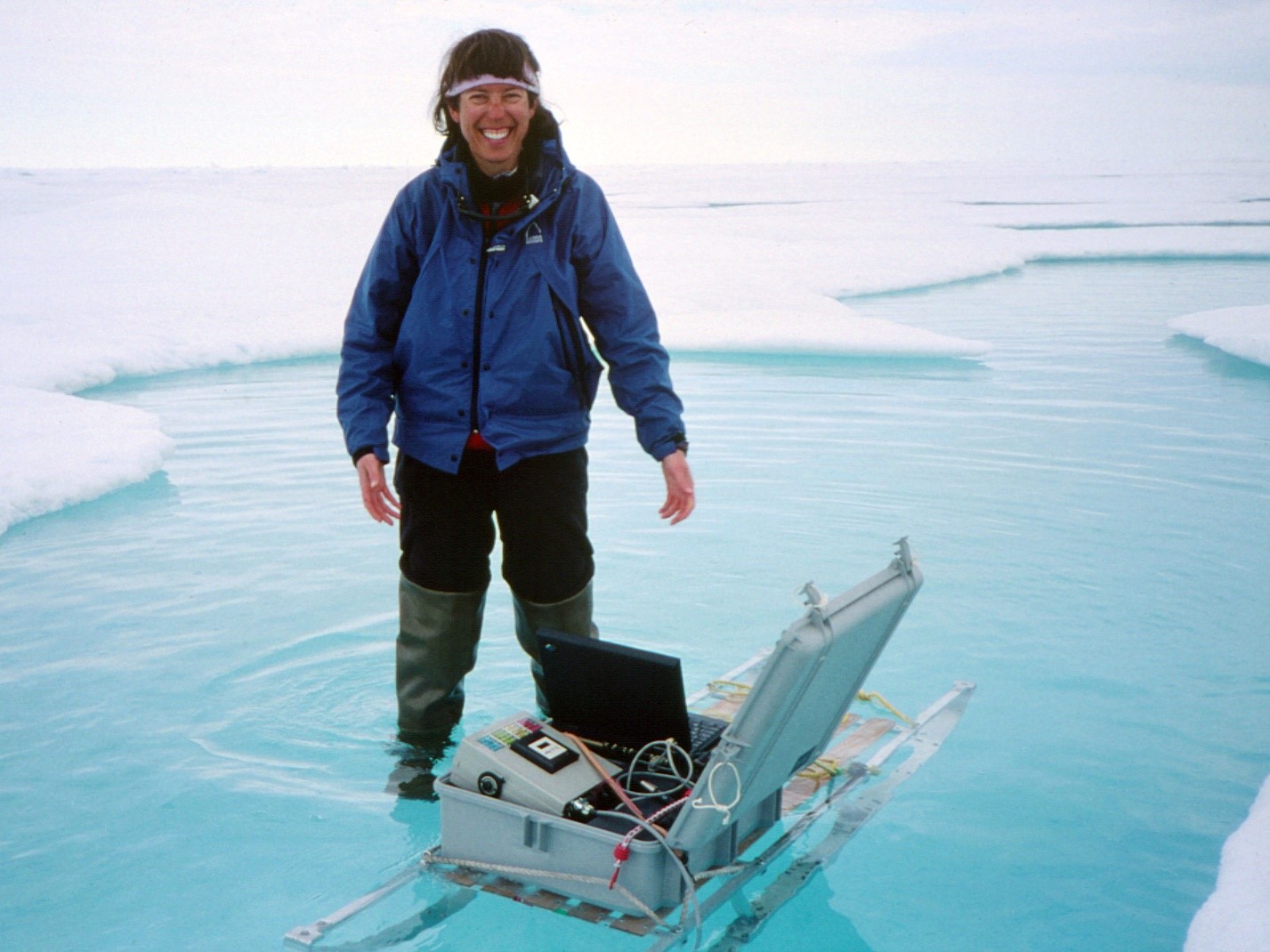
During the campaign, Light took measurements along a 200-meter (656-foot) albedo transect line. Albedo is the reflectivity of a surface and a measure of the portion of light energy the surface reflects or absorbs.
Today, she is among scientists who marvel at how durable SHEBA data sets are and at the stream of peer-reviewed literature the data have inspired.
According to ARM, SHEBA data—available through both ARM and NSF—are at the core of more than 130 papers and thousands of citations.
A single 2002 paper describing SHEBA in the Bulletin of the American Meteorological Society has 447 citations so far. Its lead author is NOAA’s Taneil Uttal, a veteran of the SHEBA deployment.
Another highly cited article, an October 1999 SHEBA overview in Eos, discussed feedback processes governing the thermodynamics of the ice pack. It has nabbed 199 citations. The main authors were Perovich, a self-described “albedo guy,” and Uttal, who directs the Polar Processes and Observations Group in NOAA’s Physical Sciences Division.
Within months, the campaign made a difference. Scientists were already busy using another 1999 paper to inform single-column models.
Some Favorites
Many scientists have their favorite papers from the SHEBA library.
Light named four. They touch on sea ice albedo, ice mass balance, and meltwater transport. The last was a phenomenon she not only appreciated as a researcher, but witnessed while standing in waders in a melt pond.
“My like for those papers is sort of selfish,” for many reasons, she says.
To start, Perovich (a mentor) led two of them—studies on albedo work. The other two, led by Hajo Eicken of the University of Alaska Fairbanks, were also in Light’s backyard of interests—studies of the meltwater transport and hydraulic controls that influence feedbacks between sea ice and albedo.
In addition, all four papers fondly evoke for Light a long-ago shipside community that grew into a sprawling array of ice camps with place names like Sarah’s Lake, Tuk, and Dog House.
The first Eicken study, from October 2002, described four stages of melting and compared the albedo of melt ponds with bare white ice. The second, two years later, linked multiyear reductions in arctic ice area to decreases in large-scale ice albedo. It also offered a hydrological model for predicting ice albedo.
The first Perovich study on Light’s list, from October 2002, described the survey-line measurements she helped to make, as well as five distinct phases in the evolution of albedo. The second paper, from March 2003, reported on the surprising thinness of multiyear ice cover—only a meter (3.3 feet) or so—and a net thinning of sea ice cover during the SHEBA year.
‘Phenomenally Successful’
“We all felt, right from the beginning, that, sure, we would all do our publications, but the real legacy was the data set. Create a good data set, integrated across disciplines, and people use it. We built it, and they came.”
Donald Perovich, SHEBA chief scientist
SHEBA was the first long-term deployment of ARM instrumentation and was “phenomenally successful” at collecting important data, says atmospheric scientist Ann Fridlind. She develops earth system models and studies cloud processes at the NASA Goddard Space Flight Center in New York; clouds in cold regions are a special interest.
In a recent book chapter, Fridlind co-authored a look at simulations of arctic mixed-phase boundary layer clouds. The narrative led off with a SHEBA cloud case study from one nine-day period in May 1998. It was one of three case studies in the chapter and was inspired by one of her favorite SHEBA studies: a January 2005 paper led by cloud researcher Paquita Zuidema of the University of Miami.
Zuidema used the nine-day case to peer into the liquid and ice phases of a long-term cloud formation. The cloud was observed by surface-based remote sensors, including radars and instruments on a 20-meter (66-foot) meteorological tower, and during three days of aircraft measurements.
SHEBA keeps on giving. The most recent paper to use its data looks at the effect of wind speed on clear-sky cooling over arctic sea ice during polar night, a period when the sun does not rise for months. It was published in August 2019.
By design, there is more than publishing to SHEBA, however.
“We all felt, right from the beginning, that, sure, we would all do our publications, but the real legacy was the data set,” says Perovich. “Create a good data set, integrated across disciplines, and people use it. We built it, and they came.”
SHEBA as Inspiration
Drift campaigns in arctic sea ice happen every “20 or 25 years,” says Perovich. The earliest such campaign scholars generally point to was led by Norwegian explorer-scientist Fridtjof Nansen from 1893 to 1896. The expedition was aboard the Norwegian ship Fram, an insulated, steam-powered schooner with a shallow draft and deck-top windmill.
SHEBA helped inspire the latest arctic-drift campaign, the Multidisciplinary Drifting Observatory for the Study of Arctic Climate (MOSAiC), billed as the largest ever in the central Arctic.
In September 2019, MOSAiC started what will be 13 months on ice. The campaign has marshaled over 60 research institutions in 19 countries and it involves more than 600 scientists, technicians, and logicians.
ARM has provided more than 50 instruments, including the first scanning radars to operate in the arctic ice pack.
In a 21st century reprise of her experience with SHEBA, Uttal will be out on the ice with MOSAiC from November 2019 to March 2020.
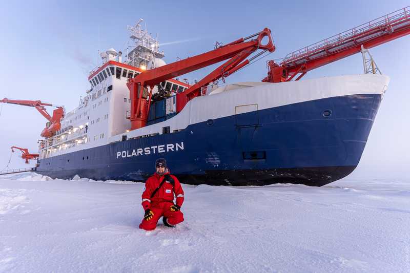
During the arctic summer months of 2020, Light will join Perovich aboard the R/V Polarstern to confront the elements and to advance science.
Just being there means a lot, she says. “There’s no substitute for getting your hands wet and cold.”
Follow Us:


Keep up with the Atmospheric Observer
Updates on ARM news, events, and opportunities delivered to your inbox
ARM User Profile
ARM welcomes users from all institutions and nations. A free ARM user account is needed to access ARM data.


