

Deciphering Cold-Air Outbreaks
Published: 21 January 2020
A 2020 ARM field campaign in Norway will investigate critical but little-understood extrusions of cold air over warm waters
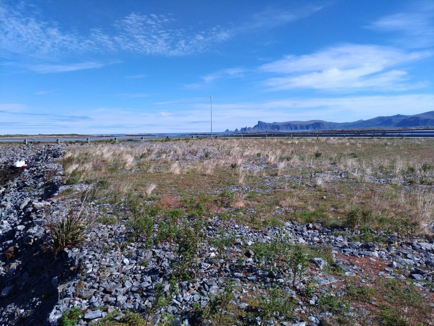
In the northernmost reaches of Norway, within the Arctic Circle, a narrow island called Andøya points like a finger to the icy edge of the Arctic Sea 1,000 kilometers (620 miles) away. It’s surrounded by peat bogs, rocky beaches, and steep mountain ranges the color of lichen. The island’s administrative center, Andenes, has been a fishing village since the Iron Age.
Andøya also happens to be an ideal place for investigating cold-air outbreaks. These globally common―and climatologically significant―atmospheric phenomena happen when a cold air mass confronts open areas of warm water.
“Warm” in this context means temperatures ranging from zero degrees Celsius (32 degrees Fahrenheit) near the edge of the Arctic to 5C (41F) near landfall in Norway during March, the coldest month.
“You don’t want to jump in,” cautions University of Wyoming atmospheric scientist Bart Geerts. “Even with a dry suit.”
But he and other scientists are eager to jump into an investigation of the shallow convective cloud formations that start at the ice edge during cold-air outbreaks and evolve as they progress over open water.
Their means of investigation, with Geerts as principal investigator, is called the Cold-Air Outbreaks in the Marine Boundary Layer Experiment (COMBLE) field campaign. It’s conducted by the Atmospheric Radiation Measurement (ARM) user facility and slated to run from January through May 2020.
The COMBLE science plan was written by about 20 people from 15 institutions in the United States and in Norway, Sweden, and Germany.
Sobering Facts
Worldwide, shallow convective cloud regimes play a key role in the Earth’s energy balance. In high-latitude marine boundary layers, such clouds are part of the atmospheric backdrop for two sobering facts.
Ice cover in the Arctic is declining faster than any earth system models have predicted, pointing to a need to improve those models. And temperatures in boreal regions (including the Arctic itself) are increasing twice as fast, on average, than anywhere else on Earth, a phenomenon known as arctic amplification.
The boreal ecosystem, including an interlocking circumpolar band of subarctic forests and bogs, covers large areas of far northern Scandinavia, Russia, and Canada.
Funding COMBLE research is the Atmospheric System Research (ASR) program of the U.S. Department of Energy. Geerts’ 2018-2021 ASR proposal includes analysis of COMBLE data, which is within his larger study of mixed-phase clouds in the polar marine boundary layer. (Such clouds are made of both liquid and ice.)
Cold-outbreak clouds happen elsewhere in the world, including over open oceans near Alaska, in the Southern Ocean, and in the Sea of Japan, which is periodically penetrated by cold air churning southward from Siberia.
By 2020, the ASR project team will have data from COMBLE to combine with measurements collected at ARM’s North Slope of Alaska atmospheric observatory and data from Measurements of Aerosols, Radiation, and Clouds over the Southern Ocean (MARCUS), a 2017-2018 ARM field campaign.
Cold-air outbreaks create cloud regimes that have not been studied much, says Geerts, “yet are important in understanding global warming and the amplification of warming in boreal regions.”
In turn, a better quantitative grasp of cold-air outbreaks will improve the way they are represented in earth system models.
Questions and a Quest

Worldwide, shallow convective clouds over oceans have more effect on Earth’s energy balance, measured as radiation, than any other cloud regime. However, little is known about the properties of the clouds formed during cold-air outbreaks or about processes within the boundary layer.
“We don’t know, for instance, whether the clouds are primarily liquid, or ice, or mixed-phase,” says Geerts. “We don’t know how precipitation forms, how heavy it is, and we don’t have a good understanding of the recirculation of moisture back into the ocean.”
To get the most out of their work on cold-air outbreaks, Geerts and his team made a facility request to ARM, which two years later set in motion two instrument installations.
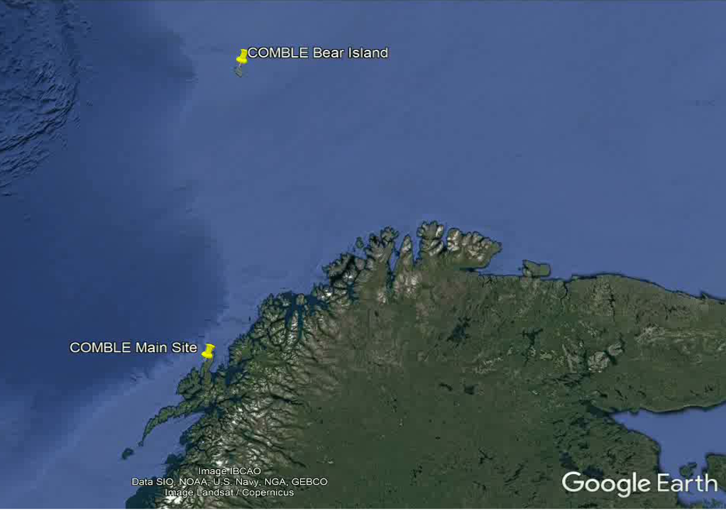
Starting in November 2019, ARM staff will set up the first ARM Mobile Facility (AMF1) in the small Andøya fishing village of Nordmela and a secondary observatory on Bear Island, roughly midway to the ice edge of the Norwegian Sea.
COMBLE will primarily investigate the role of marine boundary layer clouds during cold-air outbreaks. What is the air-sea exchange like? How do such clouds organize, and how are they affected by aerosols? How do cold-air outbreaks vary with surface, environmental, and aerosol conditions? And what role do they have in atmospheric and ocean circulation?
Yin and Yang
Warm air intruding into the Arctic causes rapid warming. At the same time, cold air is being pulled out of the Arctic and swept over warm water.
“These extrusions, if you like, or outbreaks, are basically the yin and yang of the baroclinic (temperature and pressure) variations that occur across the thermal boundary,” says Geerts. Yin (relatively warm water to the south) meets yang (ice-covered conditions to the north).
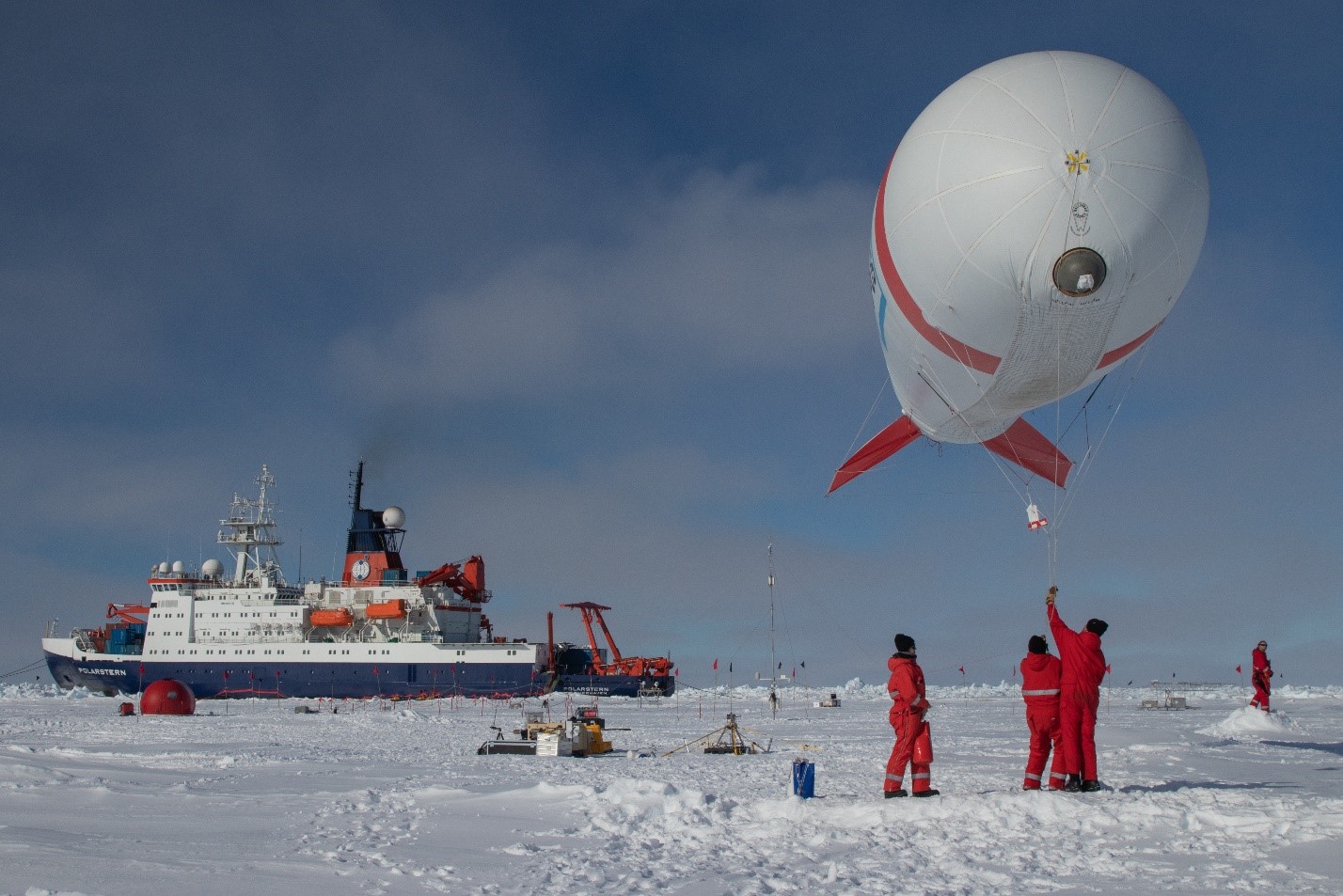
Storms are the result, which move across the region and pump warm air into the Arctic. Knowing more about these events is part of the science mission of an international expedition that is coincident with COMBLE and scientifically collateral. The main ship of the Multidisciplinary Drifting Observatory for the Study of Arctic Climate (MOSAiC) field campaign sets sail from Tromsø, Norway, in October 2019 and will do most of its work much further north of COMBLE.
MOSAiC will also last twice as long and is marshaling many more resources: 600 researchers representing 19 countries. From October 2019 through October 2020, the German icebreaker R/V Polarstern will freeze into pack ice as a drifting observatory.
Aided in part by ARM instruments, interdisciplinary teams of scientists both onboard the Polarstern and working remotely will measure the effects of diminishing ice cover on the Arctic’s atmosphere, ice, ocean, and ecosystem.
While MOSAiC researchers measure warm-air intrusions into the Arctic, says Geerts, “COMBLE will be looking at the other side of that equation, where cold air moves over open water. In that way (the two campaigns) are quite coupled.”
Polar Partners
A breakout session co-led by Geerts at the 2019 Joint ARM User Facility/ASR Principal Investigators Meeting established that MOSAiC and COMBLE represent “some of the most sophisticated suites of instruments to ever be deployed in the Arctic.”
The session organizers also held that the two campaigns will capture critical regional-scale measures of cloud and atmospheric processes related to large-scale air flows into and out of the Arctic.
COMBLE and MOSAiC will collaborate with another coincident field campaign, ArctiC Amplification: Climate Relevant Atmospheric and SurfaCe Processes and Feedback Mechanisms, otherwise known as (AC)3. Organized by three universities and two non-university research institutes in Germany, (AC)3 will investigate the processes contributing to amplified temperatures in the Arctic.
(AC)3 will document evolving air masses by using research aircraft flying between northern Scandinavia and the drifting MOSAiC site.
Together, (AC)3, COMBLE’s two sites, and MOSAiC will make up what Geerts calls “four supersites” that are uniquely arrayed to profile clouds, aerosols, precipitation, and radiation in and near the Arctic.
Logistical Advantages
Why situate COMBLE in Norway?
COMBLE will have instruments about 1,000 kilometers (620 miles) from the ice edge, as well as on an island halfway in between. The dual deployment “is a logistical asset,” says Geerts, because it captures the evolution of cloud formations during cold-air outbreaks.
There are also advantages from the ARM deployment perspective, he adds, since COMBLE can easily share experts with MOSAiC, which originates in Tromsø, Norway. From there, by car, it takes about six hours to get to COMBLE’s main observatory near Andenes on Andøya Island.
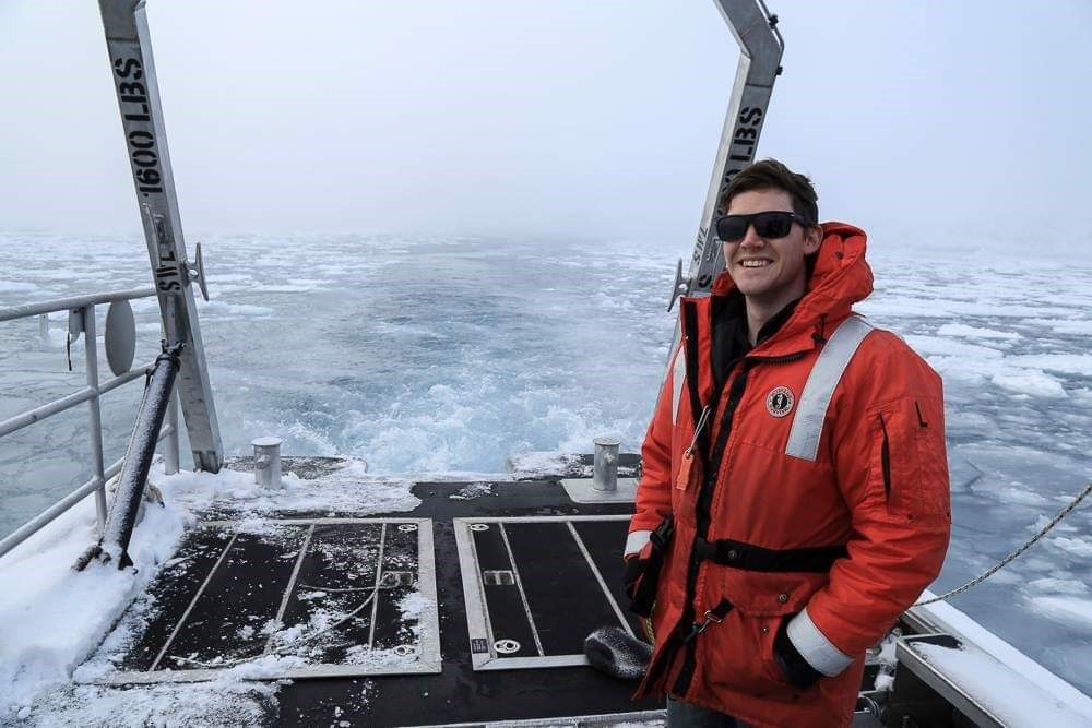
Matthew Boyer, an aerosol instrument mentor at National Laboratory (BNL) in New York and a veteran of research trips in the Arctic and Antarctica, is one of the ARM team members who will work on set-up phases for both campaigns. With him will be BNL atmospheric scientist Janek Uin, who is also an ARM instrument mentor.
For MOSAiC, they will work both wharf-side and at sea for about six weeks―then drive directly to COMBLE’s main observatory for a week of setting up aerosol instrumentation. (A separate ARM team will deploy and calibrate instruments on Bear Island.)
When Boyer leaves for Norway in September, he will be packing textbooks alongside his wool base layer and heavy gloves. That same month he starts a PhD program in atmospheric sciences at Stony Brook University.
Scientific Merit
Logistics aside, the Norway sites also offer COMBLE scientific merit.
“Climatology suggests it’s the place to be,” says Geerts. “Instruments will take measurements downwind of a region of persistent open water, which in the winter experiences more thermal instability than most anywhere else on Earth.”
That instability, he adds, is because of relatively warm waters that occasionally experience cold-air outbreaks.
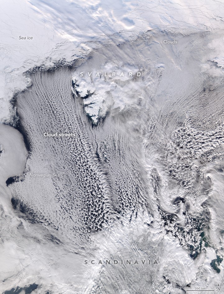
In the COMBLE study area, outbreaks initially create linear “cloud streets” over the Norwegian Sea. Those streets then gradually break into cellular “comma” clouds as the outbreak event moves southward to Scandinavia.
“We really want to understand this transition from linear to cellular cloud formations,” says Geerts. “Hopefully Bear Island will be in the right location to capture both mesoscale organizations, since it is about 500 kilometers (310 miles) from the ice edge. That is where this transition often seems to occur.”
Continuous Operations
In June 2018, Geerts scouted COMBLE installation sites in Norway with the AMF team, which is based at Los Alamos National Laboratory in New Mexico and managed by Heath Powers. In addition, they conferred with collaborators at the Andøya Space Center Observatory near the seaside village of Bleik.
Four times a day, meteorology technicians at the observatory―a service center for users of ground and aerial research platforms―routinely launch radiosondes. These untethered balloons, strung with meteorological instruments, relay measurements of temperature, humidity, and other data to ground operators.
During COMBLE, the same Norwegian technicians will launch eight radiosondes a day whenever cold-outbreak conditions appear. (Geerts designed a predictive mechanism that provides outbreak alert warnings five or more days ahead.)
Norwegian technicians will also sample the air for ice nucleating particles during periods of intensified measurements during outbreaks.
During all five months of the campaign, two ARM technicians will watch over AMF1, while Norwegian technicians will operate the instruments on Bear Island. From his office in Wyoming, Geerts will watch and guide the measurement-taking.
“There’s really no need to be out in the field,” he says. “But in a warming Arctic, there is great need for COMBLE data.”
Follow Us:


Keep up with the Atmospheric Observer
Updates on ARM news, events, and opportunities delivered to your inbox
ARM User Profile
ARM welcomes users from all institutions and nations. A free ARM user account is needed to access ARM data.


