

LASSO Case Study: Simulations Sharpen View of Cloud Cover
Published: 20 May 2018
New LASSO Data Bundles Help Close the Observation-Simulation Gap
Viewed from high above, Earth displays three color palettes that are climatologically significant. Both the brown-green land and the ice-free, deep blue oceans absorb light. Clouds, fleeting and bright white, bounce light from the sun back into space.
All three contain mysteries for scientists who try to model and predict the behavior of the planet’s atmosphere. But it is clouds, and the effect they have on the Earth’s energy budget, that pose the most enduring uncertainties for modelers.
One subset of these uncertainties relates to shallow cumulus clouds. Puffy and rain-free, these sky-borne masses of water vapor commonly inhabit about 40 percent of the sky on the days they appear.
Exactly how many of these clouds and other types are within a modeler’s grid at any one time—their “cloud fraction profile” (CFP)—is of obvious interest to those trying to estimate the role of clouds in the transfer of heat and moisture between the boundary layer and the free atmosphere.
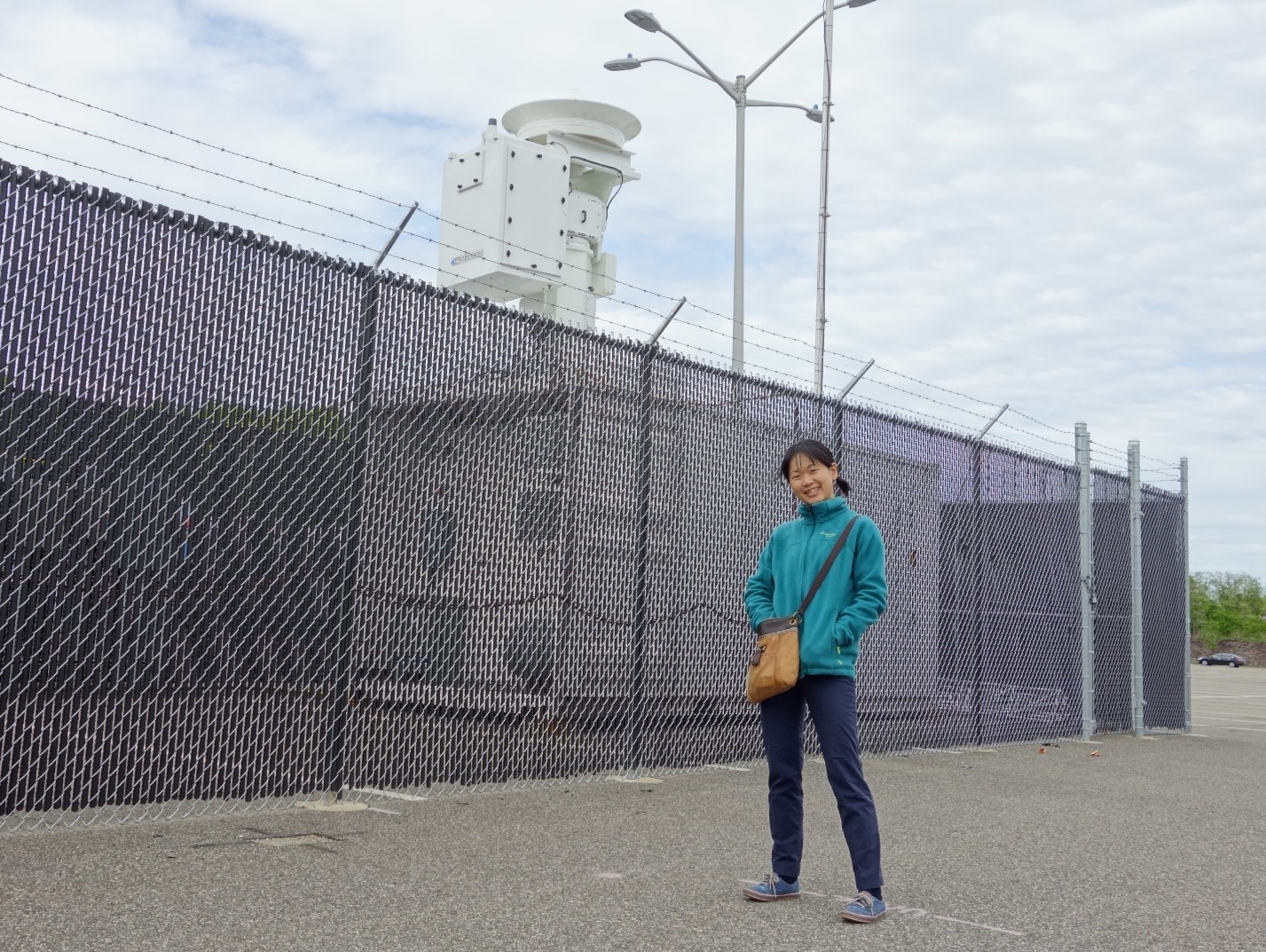
“Clouds are very important to controlling the Earth’s energy budget and temperature profiles,” says Mariko Oue of Stony Brook University in New York. Oue’s studies include the dynamics and microphysics of shallow cumuli.
In a recent paper, she and her co-authors confront the problem that shallow cumuli are not “resolved”—quantitatively described—very well in weather or earth system models.
Since shallow cumuli are often less than 25 kilometers in diameter, their properties are not well captured by present simulation schemes. It is also difficult to fully observe the three-dimensional structure of these cloud fields to improve the model simulations.
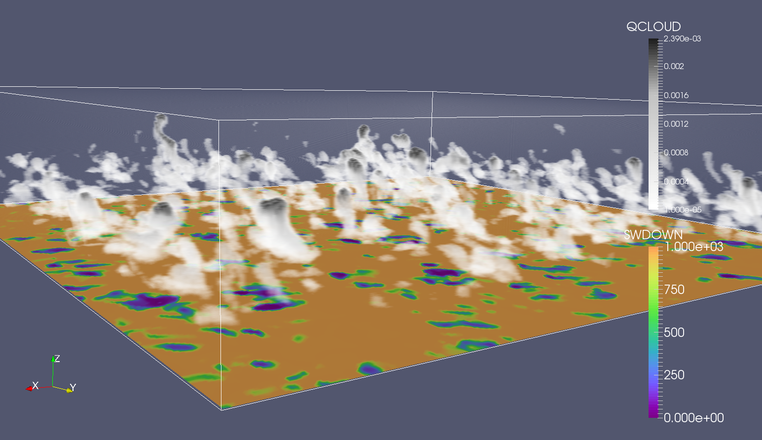
Oue’s paper is the first to demonstrate the utility of a new modeling project developed by the Atmospheric Radiation Measurement (ARM) Climate Research Facility.
The Large-Eddy Simulation (LES) ARM Symbiotic Simulation and Observation (LASSO) project started in 2015 as a pilot project and has been operational since last summer. It is just beginning to yield active experiments and a few published results.
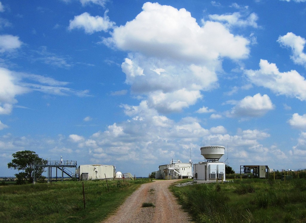
Proposed in 2013 and summarized in a report last November, LASSO is driven by measurements taken in the past few years at ARM’s Southern Great Plains (SGP) atmospheric observatory.
Large-Eddy Simulations and Beyond
As an alternative to coarser weather and earth system models, cloud field properties can be estimated by using LES, a way to mathematically model atmospheric turbulence.
Many past LES studies used “idealized” simulations in which atmospheric profiles from a single day or composited from multiple days were used to represent a particular type of cloud or environmental condition.
Across the world, scientists are going beyond these idealized LES simulations by developing testbeds that provide day-to-day comparisons of high-resolution models and observations. The idea is to understand the conditions under which the LES can best match the observations.
LASSO is prominent among these testbeds for simulation-observation comparison.
In it, ARM measurements are used to provide some of the input conditions to the model. They are also used to evaluate the model’s simulations of clouds and the atmospheric boundary layer.
So far LASSO is just targeting shallow cumulus clouds, says LASSO principal investigator William Gustafson, an atmospheric scientist at Pacific Northwest National Laboratory (PNNL).
Over the next year, the LASSO team will make decisions about using the project to tackle another, more complex, cloud regime. Candidates include clouds linked to deep convection, the marine boundary layer, and the Arctic.
“It is useful now,” says Gustafson of LASSO and its present shallow-cloud mission. “It will be even more useful in the future.”
A LASSO Case Study
In their paper, Oue and her co-authors provide the first LASSO case study.
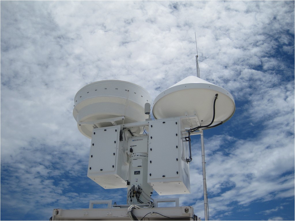
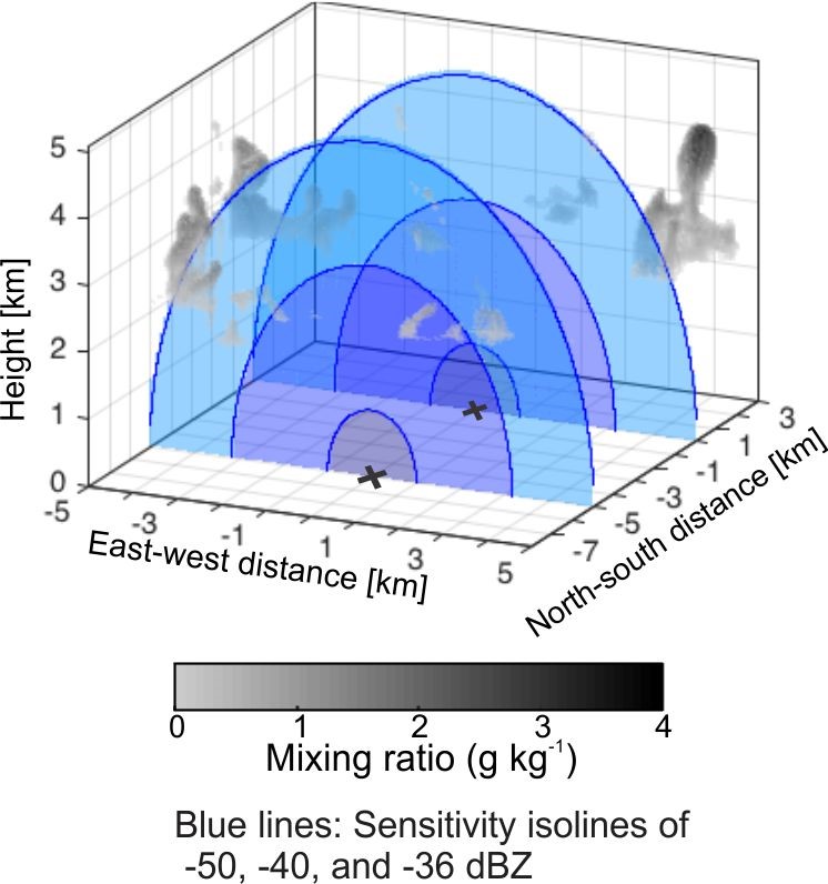
The authors—including Gustafson and collaborators from Stony Brook, Brookhaven National Laboratory, and McGill University in Canada—use virtual radars within the LASSO simulations to develop an algorithm that outlines how to deploy scanning radars.
Deployed this virtual way, for example, ARM’s scanning cloud radars (KASACRs) are more likely to capture the critical morphology of cloud fractions.
Oue’s paper confronts a basic question: To adequately capture a shallow cumulus CFP, how many vertically pointing radars—Ka-Band ARM Zenith Radars (KAZRs)—would you need? (The KAZR has a higher sensitivity than the KASACR but samples a much smaller area of the sky.)
The answer is that one KAZR is not enough. As Oue writes in the paper, short-term estimates of cloud field properties in shallow convection, lasting one to three hours, “are subject to large uncertainties.”
At the same time, she writes, “impractical numbers” of zenith profiling cloud radars would be required to accurately estimate the CFP—10 or more within a small domain 30 kilometers wide.
“The conclusion is you need too many of them,” says Gustafson. “There’s no way to go out there and actually do that experiment, but we can insert virtual radars into the model. The LASSO simulations are readily available.”
What LASSO Provides
Using radars is a great way to observe clouds, says Oue, since they make it possible to observe the interior and the tops and bottoms of clouds.
But there is a downside. “Radars fully observe clouds but not the entire sky,” she adds.
LASSO to the rescue. Its data sets provide the very high-resolution simulations that estimating cloud fields require, says the Stony Brook postdoc, who has already authored 13 papers (eight of them as lead). “Clouds are very small-scale and change with time frequently.”
LASSO simulations are powered by new high-performance computing, which combine simulated cloud fields with observational cloud fields. They make it possible to simulate clouds at very high resolution, using grid boxes only 75 or 100 meters to a side.
Oue and her co-authors combined data from two shallow cumulus cloud cases from SGP (from 2009 and 2015) with simulated observational data sets from LASSO.
The combination, she says, “provides the three-dimensional cloud set.”
LASSO Now and to Come
LASSO models are “a proxy for observations,” says Gustafson, and for now provide simulations of cloud fields that realistically take the place of in situ measurements.
In time, he adds, LASSO simulations will be useful in analyses where you need lots of data, such as cloud-aerosol interactions, where it is important to run many cases to separate the impacts of changes in aerosol from changes in meteorology.
Meanwhile, says Gustafson, LASSO simulations are already useful to modelers who work in a framework “with a lot of immeasurable unknowns,” such as the boundary layer.
In one knotty case, a University of Washington doctoral student is using machine learning to investigate the so-far unmeasurable fluxes of fluxes in the atmosphere.
Meanwhile, some researchers, such as Oue, are using LASSO directly in research. Others are simply evaluating the LASSO simulations or comparing them to other simulations.
The Oue paper shows off LASSO’s “unique capabilities,” says Gustafson. “They didn’t have the observations they needed,” but the authors found a way to make better observations by changing how radars scan the sky—the point of that new algorithm.
He and others are building an archive of LASSO data that represent day-by-day measurements of how clouds populate the sky around the SGP.
Each shallow cumulus day chosen for simulation is called a “case,” in LASSO terminology, and each case contains eight or nine “data bundles” representing separate simulations of observationally credible cloud field conditions.
So far there are two “batches” of cases ready to use, says Gustafson—five “case days” from 2015 and 13 from 2016. Within each one are separately processed data bundles that have been already collected, initialized, and packaged with specific observations.
From 2017, 32 more case days have been chosen but are not yet processed.
“Over time, as our simulation library develops,” says Gustafson, “it will make it a lot easier to test model behavior.”
The ARM Climate Research Facility is a DOE Office of Science user facility. The ARM Facility is operated by nine DOE national laboratories.
Follow Us:


Keep up with the Atmospheric Observer
Updates on ARM news, events, and opportunities delivered to your inbox
ARM User Profile
ARM welcomes users from all institutions and nations. A free ARM user account is needed to access ARM data.


