

ACORES Action, ARM Aid
Published: 18 May 2021
A 2021 ground-air study adds insights on an elusive atmospheric feature
A recent paper in the Bulletin of the American Meteorological Society (BAMS) illustrates the value of airborne data when combined with complementary ground-instrument data―in this case from the U.S. Department of Energy’s (DOE) Atmospheric Radiation Measurement (ARM) user facility.
The BAMS study, led by aerosols and cloud microphysics scientist Holger Siebert of the Leibniz Institute for Tropospheric Research in Leipzig, Germany, reported on properties at the top of the marine boundary layer over the eastern North Atlantic Ocean.
Published in January 2021, the paper summarized the July 2017 Azores Stratocumulus Measurements of Radiation, Turbulence and Aerosols (ACORES) field campaign. The ACORES campaign pulled in helicopter-borne data using instruments suspended from a tether dangling into marine clouds.
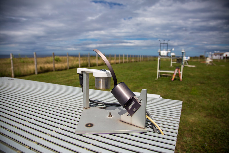
Context for ACORES airborne data came from ground instrumentation at ARM’s Eastern North Atlantic (ENA) atmospheric observatory on Graciosa Island and one other surface site.
Siebert and his co-authors set out to investigate, at a range of scales, the properties of the marine boundary layer in this remote stretch of the Atlantic. Clouds there are typically nearly pristine, though episodes of polluted air masses can stream in from western Europe, North Africa, and even North America.
The authors looked at the vertical distribution of aerosol particles, turbulence parameters, and the radiative and microphysical properties of the region’s abundant stratocumulus clouds.
Such clouds cover about 20% of the Earth’s surface. Yet scientists do not yet fully understand the critical exchange of mass and energy between the warm and dry troposphere above the cloud tops and the moist and aerosol-laden marine boundary layer below.
Entrainment Interfacial Layer
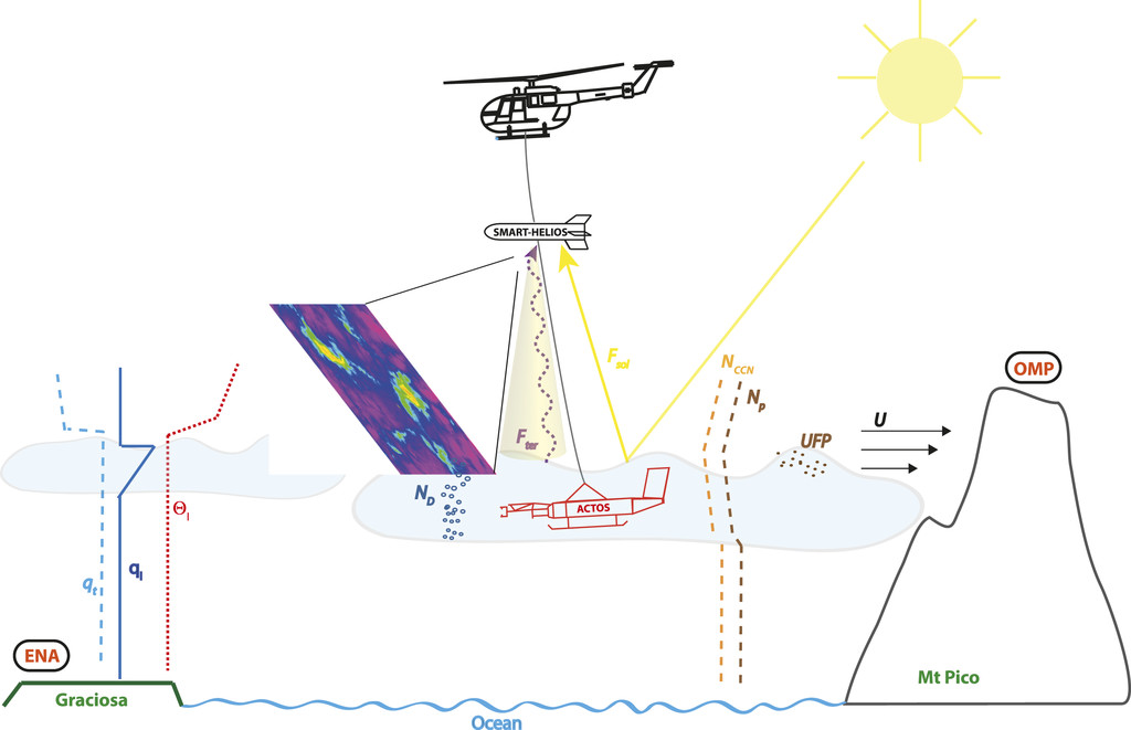
To help close this knowledge gap, Siebert and the others focused on learning more about where this exchange of momentum and heat takes place―the entrainment interfacial layer. (Entrainment is a process by which moister air captures drier air.)
Often only a few meters deep, the entrainment interfacial layer is best studied by a stationary or slow-moving platform. This explains the observation strategy described in the paper: a twin-engine Airbus helicopter capable of carrying two instrument payloads suspended from a tether 170 meters (558 feet) long.
In the span of 17 research flights, with the helicopter safely above the clouds, one instrument payload gathered data on terrestrial and solar irradiance; the payload’s thermal-infrared cameras helped record the cloud’s horizontal structure.
The other, larger device (5.5 meters long, or 18 feet) hung farther down. It took in measurements from inside the clouds, including wind speed, humidity, and liquid-water content.
There were two complementary ground-based instrument sites. ARM instruments on Graciosa drew in helpful contextual measures, including aerosol particle number size distributions down to the size of 10 nanometers, about the size of four DNA molecules side by side. (A nanometer is one-billionth of a meter.)
Instruments at the Observatório da Montanha do Pico (OMP) on Mount Pico were at a high enough altitude (2,225 meters, or 7,299 feet) to measure conditions in the troposphere. OMP is on Pico Island, about 80 kilometers (50 miles) from Graciosa.
Co-authors of the paper from Michigan Technological University in Houghton, Michigan, acknowledged support from DOE’s Atmospheric System Research (ASR) program. They are part of a 2019–2022 ASR project on entrainment and aerosol effects on marine boundary-layer clouds.
Five Cases

Siebert and his co-authors outlined five sample cases under different conditions and with different target properties, including vertical structure, aerosol layering, and the horizontal variability of cloud-top temperature.
One conclusion was that the ground-based stations took measurements that are accurately representative of the regional marine environment. Another was that changes in cloud properties can vary significantly even within gradients of 100 meters (328 feet).
Meanwhile, the authors wrote, the co-location of helicopter data with ground measurements was “of major importance to verify remote sensing retrievals.”
ACORES happened in coordination with the summer 2017 intensive operational period of an ARM field campaign called Aerosol and Cloud Experiments in the Eastern North Atlantic (ACE-ENA). The ACE-ENA campaign used ENA measurements and collected data with ARM’s now-retired Gulfstream-159 (G-1) research aircraft.
The authors say that the overlap of ACORES and ACE-ENA data will provide more ways in the future to compare and combine measurements.
ACORES data are available upon request from the authors. Read the BAMS paper now.
Follow Us:


Keep up with the Atmospheric Observer
Updates on ARM news, events, and opportunities delivered to your inbox
ARM User Profile
ARM welcomes users from all institutions and nations. A free ARM user account is needed to access ARM data.


