

Storm Chasers, Knowledge Makers
Published: 18 May 2021
Recent work spanning two related field campaigns in Argentina gets play in the same journal
What makes a good story?
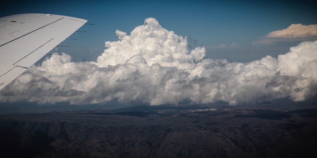
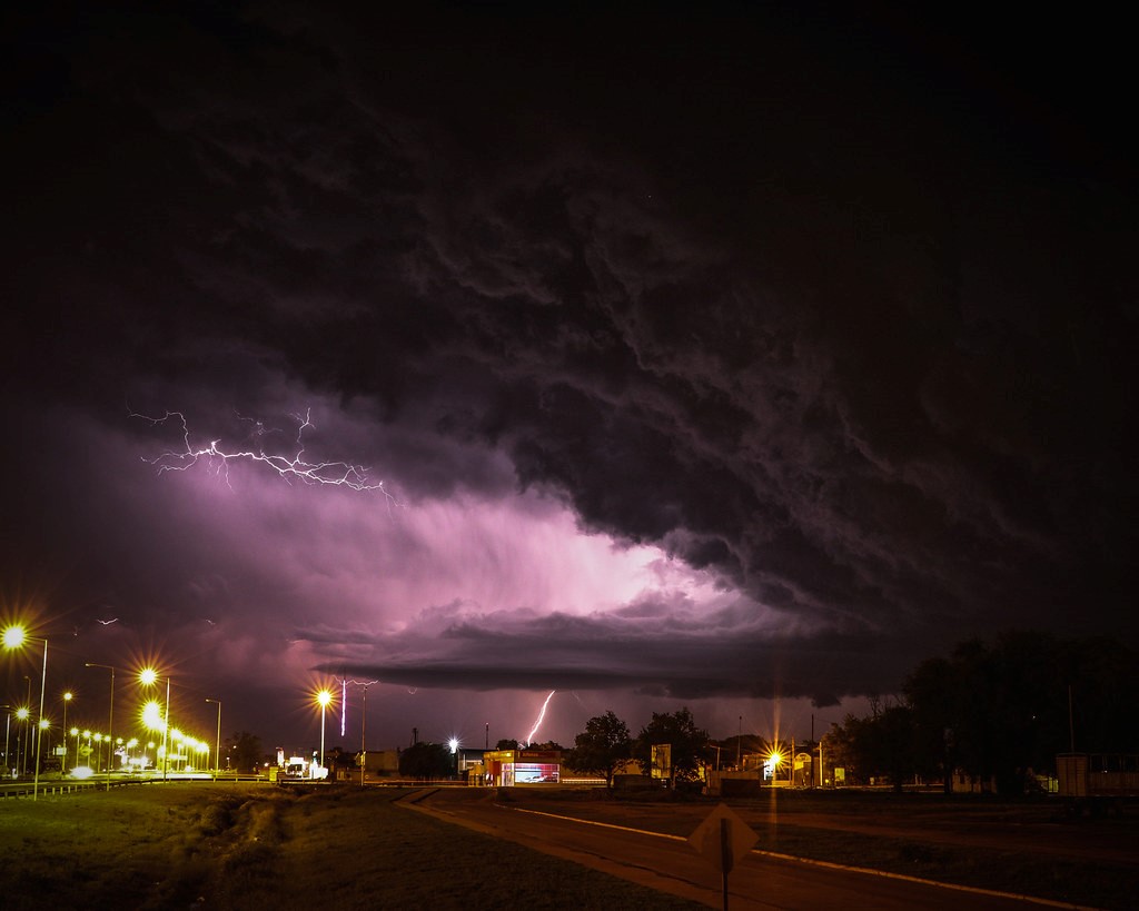
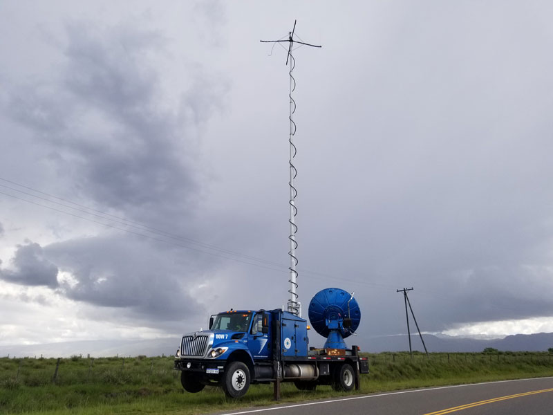
Try mixing these ingredients: tall thunderheads, crashing rain, hail as big as baseballs, sky-gashing lightning, racing radar-mounted trucks, a research aircraft, and South American mountains famous for big storms forming overhead.
As of April 2021, peer-reviewed papers put all this into scientific perspective in the Bulletin of the American Meteorological Society (BAMS). These early online releases summarize related field campaigns that illustrate, among many other things, the value of data from the U.S. Department of Energy’s (DOE) Atmospheric Radiation Measurement (ARM) user facility.
Each also reports initial findings, current research, and directions for future work.
A BAMS paper published April 13 outlines an epic, seven-month ARM exploration of orographic cloud life cycles in mountainous north-central Argentina. (Orographic atmospheric processes are those that evolve over rising terrain.) Spanning 2018 and 2019, the Cloud, Aerosol, and Complex Terrain Interactions (CACTI) field campaign swept up data from more than 50 ground instruments as well as others deployed on ARM’s now-retired Gulfstream-159 (G-1) research aircraft.
Closely linked to CACTI by timing, mission, and geography was the RELAMPAGO campaign, summarized in a paper published online by BAMS just a few days after the CACTI study. RELAMPAGO, named after the Spanish word for “flash of lightning,” is spelled out as Remote sensing of Electrification, Lightning, and Mesoscale/microscale Processes with Adaptive Ground Observations.
RELAMPAGO, supported by the National Science Foundation, joined CACTI in a joint intensive operational period from November to December 2018. It featured 22 G-1 flights.
From the beginning, both field campaigns were planned in tandem and were always intended to generate scientific synergies.
The two papers are part of a special collection of American Meteorological Society studies related to the sister campaigns.
CACTI Past, Current, and Future
The CACTI report, led by principal investigator Adam Varble from Pacific Northwest National Laboratory (PNNL) in Washington state, is anchored by a lessons-learned section to help future campaigns.
Choose the right observation site, the authors advise, and balance science needs with logistical realities. Choose the right measurement strategies―when to launch radiosondes, for instance. Monitor data in real time to fix problems fast. And create data sets informed by consistent measurement strategies.
The lessons were hard-won during the campaign, which, in the end, made many of the first-ever measurements of orographic cloud life cycles that were paired with interactions with the surrounding environment. (Many of CACTI’s aerosol measurements, for instance, were the first collected in subtropical South America.)
The campaign also lasted an entire warm season.
A Storm and Study Hotspot
Both RELAMPAGO and CACTI took place in an ideal outdoor laboratory for observing cloud types and processes, Argentina’s Sierras de Córdoba range.
This “storm-generating hotspot” (as stated in the CACTI paper’s title) is known for some of the world’s deepest convective storms. Intense supercells organize nearby, as illustrated by a December 2019 study and another that appeared in print in August 2020.
Such storms are often packed with hail of various sizes worldwide. Hail is particularly frequent in subtropical South America compared with other regions of the world. A December 2019 study used CACTI-RELAMPAGO measurements in combination with long-term satellite data to identify hailstorm characteristics and the environments that support them.
The two sister campaigns also provided new insights into the frequency of lightning strikes during severe convective storms. The region of study was already well known for lightning. A June 2020 study established two notable records. One was for the world’s greatest horizontal distance for an individual lightning flash (about 709 kilometers, or 441 miles) in southern Brazil in October 2018. The other was for the greatest duration for a single lightning flash: an estimated 16.73 seconds over northern Argentina in March 2019.
An August 2020 paper gave an overview of RELAMPAGO’s 11-station Lightning Mapping Array (LMA). During 163 days of operation, the LMA observed 2.9 million lightning flashes.
From Observations to Data
During the campaigns, the weather cooperated by being stormy.
For CACTI, 212 fruitful days between October 2018 and April 2019 included 191 that produced shallow liquid clouds; 83 of the days generated deep convection directly over the primary observing site.
The G-1 flights were observationally consequential too. Nineteen of the 22 witnessed clouds with clear ties to topography (a major CACTI interest). Eight included the initiation of deep convection during or just after flights.
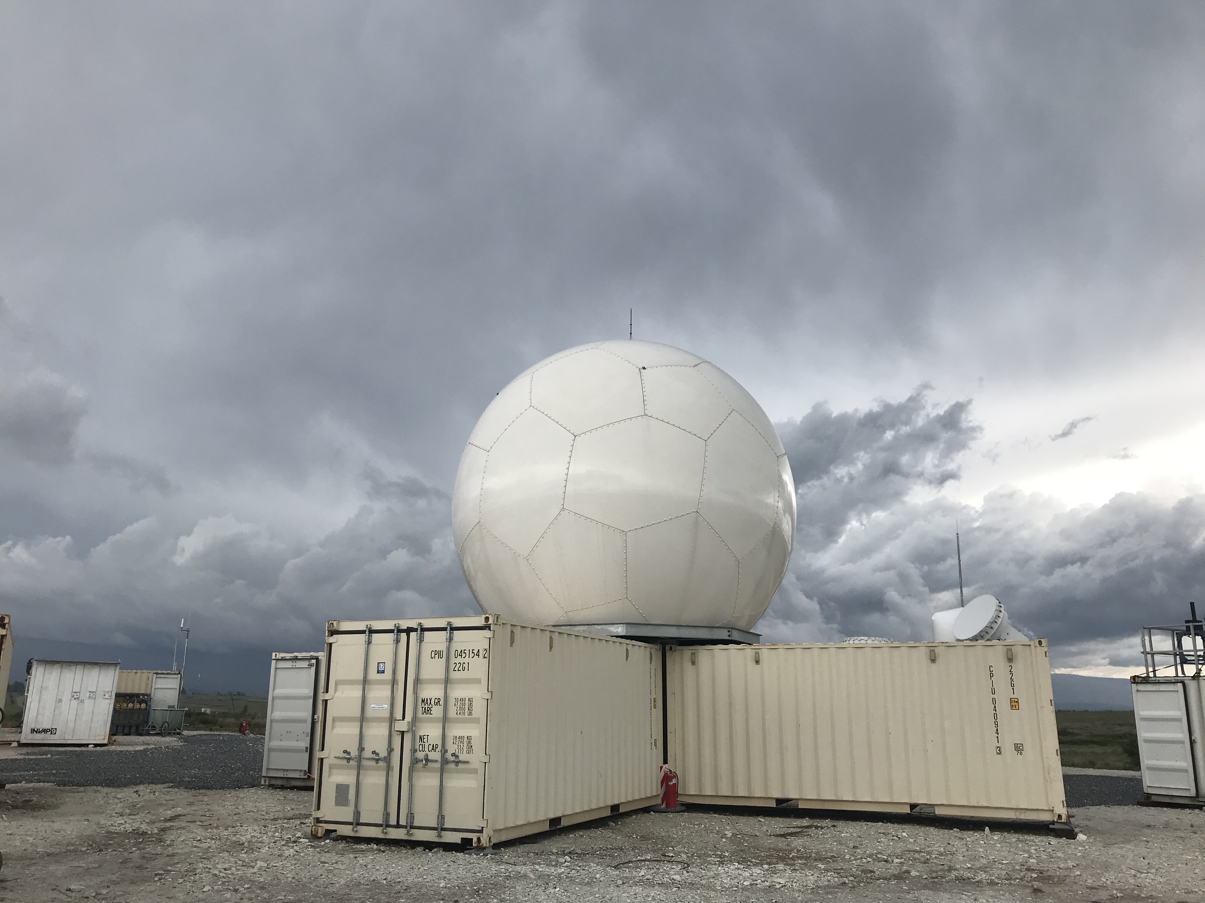
The 50-plus instruments at ARM’s main site included, for the first time, the second-generation C-Band Scanning ARM Precipitation Radar (CSAPR2). The CSAPR2 is capable of simultaneous vertical and horizontal polarization, which allows scientists to derive estimates of rainfall rates and identification of precipitation type from the data.
ARM instrumentation has helped create 200-plus CACTI data sets. Additional data sets are in the pipeline from principal investigators.
The campaign has also produced more than 20 ARM value-added products, which combine datastreams to produce retrievals of value to researchers.
CACTI has also inspired six projects funded by DOE’s Atmospheric System Research (ASR) program, which had a small role in funding the campaign. Four of the ASR projects aspire to improve model representations of convection, convective precipitation, cold pools, and other factors. Two others combine CACTI data with measurements from other field campaigns to improve scientific understanding of deep convection processes, including the vertical transport of aerosols.
Efforts Underway
CACTI data are grist for research efforts just getting off the ground and papers just underway. The BAMS authors note ongoing research such as investigations comparing deep convection in Argentina and at ARM’s Southern Great Plains (SGP) atmospheric observatory in Oklahoma.
Current research is also looking into:
- ice-nucleating particles with apparent links to the region’s agricultural soils and precipitation
- impacts of cloud condensation nuclei and turbulence on shallow cloud rain formation
- two-way interactions between aerosols and deep convection
- environmental controls on convective updrafts, deep convection initiation, and storm upscale growth
- the evolution of extremely deep convective events, including storm dynamics and lightning production.
This last research pathway is illustrated by an October 2020 paper led by PNNL’s Paloma Borque, a RELAMPAGO-CACTI participant.
Modelers also are looking at CACTI data.
For one, University of Utah PhD candidate Zhixiao Zhang “just had a paper accepted (pending minor revisions) evaluating how well a model simulates the growth of storm systems in Argentina,” says Varble, his dissertation advisor. “His current research is now investigating the ingredients that control the initial growth of storm complexes using CACTI data and how well models reproduce that, including how it depends on the model resolution.”
Other modelers inspired by CACTI may support better model-observation integration; help simulate water and food resources in the face of climate change; and leverage first-ever aerosol data sets.
Meanwhile, inspired by rich CACTI data, ARM is adding deep convection as a focus in its Large-Eddy Simulation (LES) ARM Symbiotic and Simulation (LASSO) activity. Until recently, LASSO’s LES ensemble runs focused only on shallow cumulus cases at the SGP.
A RELAMPAGO ‘Storm Safari’
Leading the BAMS article on RELAMPAGO is Stephen Nesbitt, a professor of atmospheric science at the University of Illinois, Urbana-Champaign.
Joining him are co-authors from the United States, Brazil, and Argentina, who made the campaign the smooth and data-rich international effort it turned out to be. In all, 200 scientists and students from four continents participated in documenting continental convection, its processes, and its impacts on society.
The paper’s title calls the campaign “a storm safari in subtropical South America.” The fieldwork featured not only coincident research flights by ARM’s G-1 aircraft but also roving radar-mounted trucks―all the better to chase the intense storms that boom and flash across the region.
RELAMPAGO was situated in a uniquely storm-dense area of continental and mesoscale topography. Deep convection events in the complex terrain of the Sierras de Córdoba and the Andes can pack heavy rain, copious hail (some of the largest in the world), and frequent lightning strikes.
To make the campaign setting clear: The Sierras are 500 kilometers―about 300 miles―east of the Andes.
“We’re really excited to be so close here to the action,” says Nesbitt in a video about the campaign’s science.
The work was motivated by the need to better understand high-impact weather in Argentina and Brazil, starting with the physical processes of such storms and how they affect life, property, and society.
Five Issues
The ingredients and evolution of such storms have attracted intensive studies in the U.S. Great Plains and Europe. But until RELAMPAGO and CACTI, such storms in South America had not been the subjects of extensive onsite measurements. (Other storm hotspots in the world, including in central Africa and the Indian subcontinent, have been identified by satellite data but still await prolonged observation.)
RELAMPAGO, with an underlying interest in the anatomy and forecasting and nowcasting of severe storms worldwide, focused its science on five issues:
- how convection initiates
- severe weather
- storm “upscale” growth as storms combine with one another
- hydrometeorology―the transfer of water and energy between land and the lower atmosphere
- lightning and electrification.
“Together, the CACTI and RELAMPAGO data sets have provided an unprecedented view of the life cycle of convective cloud development and the hazards that go along with them.”
Stephen Nesbitt, RELAMPAGO’s science lead from the University of Illinois, Urbana-Champaign
The BAMS paper called CACTI a “sister campaign” that created the collaboration’s “integrated and expansive observational approach.” Scientists from both campaigns coordinated their investigations of storm generation, growth and intensification, and land-atmosphere interactions. Both had fixed and mobile assets, including ARM’s G-1 aircraft and radar trucks (a RELAMPAGO feature). Both also had balloon-borne sounding sites.
Nesbitt, the RELAMPAGO science lead, deployed instruments to monitor streamflow in local waterways and hail pads to measure the number of impacts. Another team of his monitored dozens of instruments to record lightning flash rates, including video cameras and instruments that measure electric field charge.
The campaign also drew in data from geostationary NOAA satellites and tapped citizen scientists to submit geolocated data on hail size.
Nesbitt and his co-authors describe RELAMPAGO as a “generational opportunity for South American scientists and students,” who fanned out to cooperate on matters of forecasting, observation, and data analysis. With outreach in mind, the campaign Twitter account gained thousands of followers.
Eight scientific videos, produced by the National Center for Atmospheric Research (NCAR) in Colorado, arose from RELAMPAGO as well. One was on gargantuan hail; another introduced the RELAMPAGO team, the campaign setting, and its mission.
“We have data coming in all the time,” says NCAR software engineer Mike Dixon.
Case-study analysis and modeling efforts will continue. Two broad goals are at play: to see how RELAMPAGO and CACTI can illuminate what scientists know about intense convective systems globally and to help regional forecasters in South America keep track of extreme weather.
“Together, the CACTI and RELAMPAGO data sets have provided an unprecedented view of the life cycle of convective cloud development and the hazards that go along with them,” says Nesbitt. “That allows us to better predict storms now and as the climate changes.”
Follow Us:


Keep up with the Atmospheric Observer
Updates on ARM news, events, and opportunities delivered to your inbox
ARM User Profile
ARM welcomes users from all institutions and nations. A free ARM user account is needed to access ARM data.


