

2017 AGU Presentations Featuring ARM Data
Published: 5 December 2017
With more than 20,000 attendees expected, the 2017 American Geophysical Union (AGU) Fall Meeting might feel overwhelming. We make it easy for you to find ARM/ASR-relevant science, meet up with colleagues, and discover new connections.
Below is a list of ARM/ASR-related AGU meeting highlights. Follow us on Twitter (@armnewsteam) and Facebook (@arm.gov) for a real-time guide to relevant activities using the hashtags #ARMAGU and #AGU17. Go here to find a full list of ARM-related presentations and posters and the ASR-related sessions, talks, and posters.
Be sure to meet up with your colleagues at the ARM booth in the exhibition hall—Booth 1656.
Town Halls
- U.S. Global Change Research Program (USGCRP) Interagency Working Group on Integrated Observations
Monday, December 11, 12:30-1:30 p.m., rooms 228-230
Join ARM U.S. Department of Energy Program Manager Sally McFarlane in this discussion of interagency coordinated observational activities and how they can be improved.
- Observationally Driven Routine Large-Eddy Simulations: Enhancing Community Research through the DOE LASSO Project
Tuesday, December 12, 12:30-1:30 p.m., rooms 265-266
The Large-Eddy Simulation (LES) ARM Symbiotic Simulation and Observation (LASSO) pilot phase has ended, and recommendations were recently released regarding what ARM should implement for routine operations. Come learn about this new capability and provide feedback regarding its application.
Atmospheric Discoveries from Antarctica
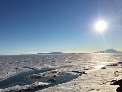
In 2017, researchers completed the first substantial climate measurements on the West Antarctic Ice Sheet in 50 years. From November 2015 to January 2017, sophisticated instruments collected data as part of the ARM West Antarctic Radiation Experiment (AWARE) that may help explain changes in this remote continent—and the potential global implications.
Tuesday, December 12, 5-5:15 p.m.
Presentation in the New Orleans Ernest N. Morial Convention Center – 291-292
- C24C-05: Meteorological Drivers of West Antarctic Ice Sheet and Ice Shelf Surface Melt. Ryan C. Scott, Scripps Institution of Oceanography
Friday, December 15, 8 a.m.-12:20 p.m.
Poster in the New Orleans Ernest N. Morial Convention Center – Poster Hall D-F
- A51E-2116: Influence of Meteorological Regimes on Cloud Microphysics over Ross Island, Antarctica. Caitlin Glennon, St. Olaf College
Studying the Impact of Smoke from African Fires on Low Clouds
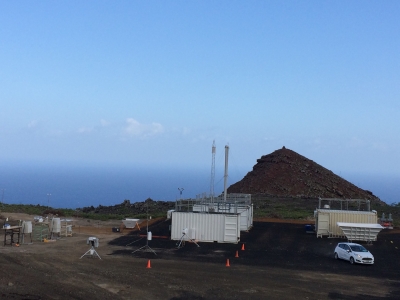
Over 1,000 miles off the coast of Angola in West Africa is Ascension Island. From June 1, 2016, through October 31, 2017, this tiny island in the South Atlantic Ocean was ground zero for ARM’s Layered Atlantic Smoke Interactions with Clouds (LASIC) campaign to gather data on how the properties of smoke evolve after long-range transport through the atmosphere—particularly their ability to absorb shortwave radiation—and assess how such smoke affects low clouds.
Monday, December 11, 4:30-5 p.m.
Presentations in the New Orleans Ernest N. Morial Convention Center – 395-396
- A14B-03: A First Summary of the Layered Atlantic Smoke Interactions with Clouds (LASIC) Campaign in the Remote Southeast Atlantic. Paquita Zuidema, University of Miami
- A14B-04: Cumulus Population and Microphysical Properties Retrieved from a Synergy of Scanning Radar and Shortwave Zenith Radiances over Southeast Atlantic. Yann Blanchard, University of Reading
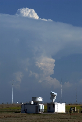
Scrutinizing Storms—Initiation, Organization, and Life Cycle
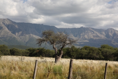
From September 2018 to April 2019, scientists leading the Cloud, Aerosol, and Complex Terrain Interactions (CACTI) field campaign will position cutting-edge atmospheric instruments nearly 3,500 feet above sea level near the rugged Sierras de Córdoba mountain range of north-central Argentina. This area is home to some of the most intense, largest, and longest-lived storms in the world. For part of the campaign, scientists will also deploy the ARM Aerial Facility Gulfstream-159 aircraft to take measurements inside storms. With this wealth of instrumentation, CACTI will amass an unprecedented data set about the storms and their interaction with the environment in subtropical South America.
Thursday, December 14, 9:15-9:30 a.m.
Presentation in New Orleans Ernest N. Morial Convention Center – 291-292
- H41K-06: Improving High Impact Weather and Climate Prediction for Societal Resilience in Subtropical South America: Proyecto RELAMPAGO-CACTI (Invited). Stephen W. Nesbitt, University of Illinois at Urbana-Champaign
Improving Model Simulation of Ice Crystals Using Thunderstorm Data
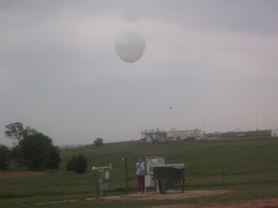
Large storm clouds influence the Earth’s climate system by redistributing heat and moisture in the atmosphere and delivering rain to the surface, yet current earth system models struggle to accurately reproduce storm systems. To help resolve this issue, the U.S. Department of Energy and National Aeronautics and Space Administration (NASA) collaborated on the Midlatitude Continental Convective Clouds Experiment (MC3E) at the ARM Southern Great Plains site in central Oklahoma in April and May 2011. The collaboration leveraged the most comprehensive array of ground-based instruments in the central United States and provided one of the most complete data sets for storms and their environment to date.
Monday, December 11, 8-8:15 a.m.
Presentation in New Orleans Ernest N. Morial Convention Center – 398-399
- A11P-01: The Use of a Probabilistic Approach to Compare Observed and Simulated Cloud Properties: Results from a Squall Line Sampled during MC3E (Invited). Greg M. McFarquhar, University of Oklahoma
Using Unmanned Aerial Systems for Atmospheric Science
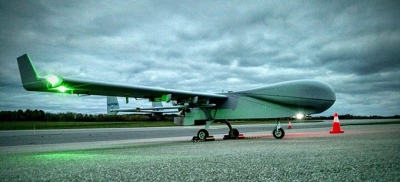
Unmanned aerial systems (UAS) and tethered balloon systems are augmenting ground measurements at Oliktok Point, Alaska, where the third ARM Mobile Facility (AMF3) is gathering ground data. In this poster session, scientists provide an overview of these UAS measurement campaigns and routine operations, as well as plans for future research activities.
Wednesday, December 13, 1:40-6 p.m.
Posters in the New Orleans Ernest N. Morial Convention Center – Poster Hall D-F
- A33I-2500: Scientific Infrastructure to Support Atmospheric Science, Aerosol Science and UAS’s for the Department of Energy’s Atmospheric Radiation Measurement Programs at the Mobile Facility 3 Located at Oliktok Point, Alaska. Fred Helsel, Sandia National Laboratories
- A33I-2501: Towards Routine Measurements of Meteorological and Aerosol Parameters Using Small Unmanned Aerial and Tethered Balloon Systems. Fan Mei, Pacific Northwest National Laboratory
- A33I-2503: ARM Aerial Facility ArcticShark Unmanned Aerial System. Beat Schmid, Pacific Northwest National Laboratory
- A33I-2504: ARM Tethered Balloon System & AALCO Activities at AMF3 Site at Oliktok Point, Alaska. Joe Hardesty, Sandia National Laboratories
- A33I-2510: Use of Unmanned Aerial Systems to Study Atmospheric Processes during Sea Ice Freeze Up. Gijs de Boer, University of Colorado, Boulder
LASSO Corralling Models and Measurements
The ARM Facility is adding modeling to its suite of capabilities. The recently completed LASSO modeling pilot project ties together observation data and large-eddy simulation (LES) modeling to support the study of atmospheric processes, the improvement of observational retrievals, and parameterizations of clouds, aerosols, and radiation in earth system models.
Tuesday, December 12, 9:20-9:35 a.m.
Presentation in New Orleans Ernest N. Morial Convention Center – 398-399
- A21O-06: Continental Shallow Convection Cloud-Base Mass Flux from Doppler Lidar and LASSO Ensemble Large-Eddy Simulations. Andrew Mark Vogelmann, Brookhaven National Laboratory
Friday, December 15, 11:05-11:20 a.m.
Presentation in New Orleans Ernest N. Morial Convention Center – La Nouvelle C
- A52C-04: Sensitivity of Shallow Convection in Large-Eddy Simulations to Forcing Datasets Across a Range of Days: Examining Results from the DOE LASSO Project. William I. Gustafson, Pacific Northwest National Laboratory
The ARM Climate Research Facility is a DOE Office of Science user facility. The ARM Facility is operated by nine DOE national laboratories, including .
Follow Us:


Keep up with the Atmospheric Observer
Updates on ARM news, events, and opportunities delivered to your inbox
ARM User Profile
ARM welcomes users from all institutions and nations. A free ARM user account is needed to access ARM data.


