

New ARM Data Epoch Assembled From COMBLE Campaign
Published: 27 June 2023
A new data epoch focused on the Cold-Air Outbreaks in the Marine Boundary Layer Experiment (COMBLE) is now available from the Atmospheric Radiation Measurement (ARM) user facility.
ARM data epochs are periods of well-characterized, calibrated measurements focused on a particular atmospheric phenomenon.
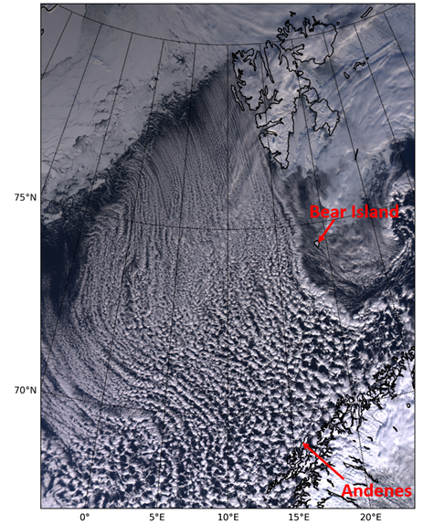
For COMBLE, ARM deployed one of its mobile observatories on the coastal island of Andøya in northern Norway with a smaller instrument installation farther north on Bear Island, on the border of the Norwegian and Barents seas. From December 2019 through May 2020, observations quantified the properties of boundary-layer convection and air-mass transformations in cold-air outbreaks (CAOs) over open water in the Arctic.
The COMBLE data epoch features 76 days with CAO conditions. The breakdown of days is as follows:
- December 2019: 9 (December 1–2, 7, 9–10, 18–19, 30–31)
- January 2020: 11 (January 3–5, 9–10, 13–14, 20–22, 25)
- February 2020: 16 (February 2–6, 10–14, 18–19, 23–24, 26)
- March 2020: 16 (March 10, 12–16, 18–20, 25–31)
- April 2020: 15 (April 1, 3–5, 8–13, 16–17, 24–26)
- May 2020: 9 (May 4, 6–7, 10–15).
This epoch features 73 data products providing information about aerosols, atmospheric state, atmospheric carbon, cloud properties, surface energy budget, and surface properties.
Among those data products are characterized and corrected data from the Ka- and W-band scanning ARM cloud radars (KASACR and WSACR) and the Ka-Band ARM Zenith Radar (KAZR), which all operated as part of ARM’s mobile observatory. The KASACR, WSACR, and KAZR data are considered b1-level, meaning they underwent calibration, correction, and quality control processes beyond ARM’s standard quality checks and corrections.
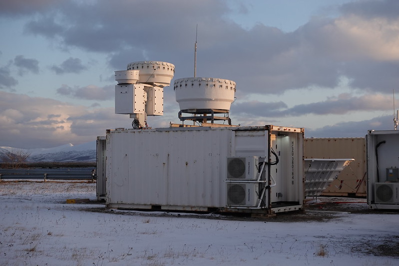
ARM staff applied reflectivity offsets to the KASACR (0.35 dB) and WSACR (1.4 dB) data to bring them in line with the KAZR reflectivity. In addition, the data include ground clutter and meteorological echo masks, which will allow scientists to quickly remove background noise and clutter when needed.
More information about the COMBLE b1-level radar data processing is available in this technical document.
The COMBLE data epoch is the third assembled by ARM. The other epochs are convective clouds and surface rainfall observed during the 2018–2019 Cloud, Aerosol, and Complex Terrain Interactions (CACTI) campaign in Argentina and changes in atmospheric pressure at ARM sites after the January 2022 volcano eruption in Tonga.
Access the COMBLE data epoch in the ARM Data Center. (Go here to create an account to download the data.)
Data epochs can be also accessed by using ARM Data Discovery’s guided search function and selecting the Epoch option.
Feedback is welcome to improve the COMBLE epoch. Please share your input with the ARM Data Center by clicking on the red Feedback tab on the right-hand side of Data Discovery. You may also contact ARM with any questions you have about the data.
Follow Us:


Keep up with the Atmospheric Observer
Updates on ARM news, events, and opportunities delivered to your inbox
ARM User Profile
ARM welcomes users from all institutions and nations. A free ARM user account is needed to access ARM data.


