

KASACR Data Quality Masks Value-Added Product Now Available in Evaluation
Published: 20 May 2018
Evaluation data for the Ka-Band Scanning ARM Cloud Radar (KASACR) Data Quality Masks are now available from the Aerosol and Cloud Experiments in the Eastern North Atlantic (ACE-ENA) field campaign conducted in June and July 2017. The specific dates covered in this data set are June 18 through July 31, 2017.
Data quality masks help users remove data not suited for their work. Generally, signals from non-meteorological targets, such as ground clutter, or with weak echoes are undesirable for radar data processing.
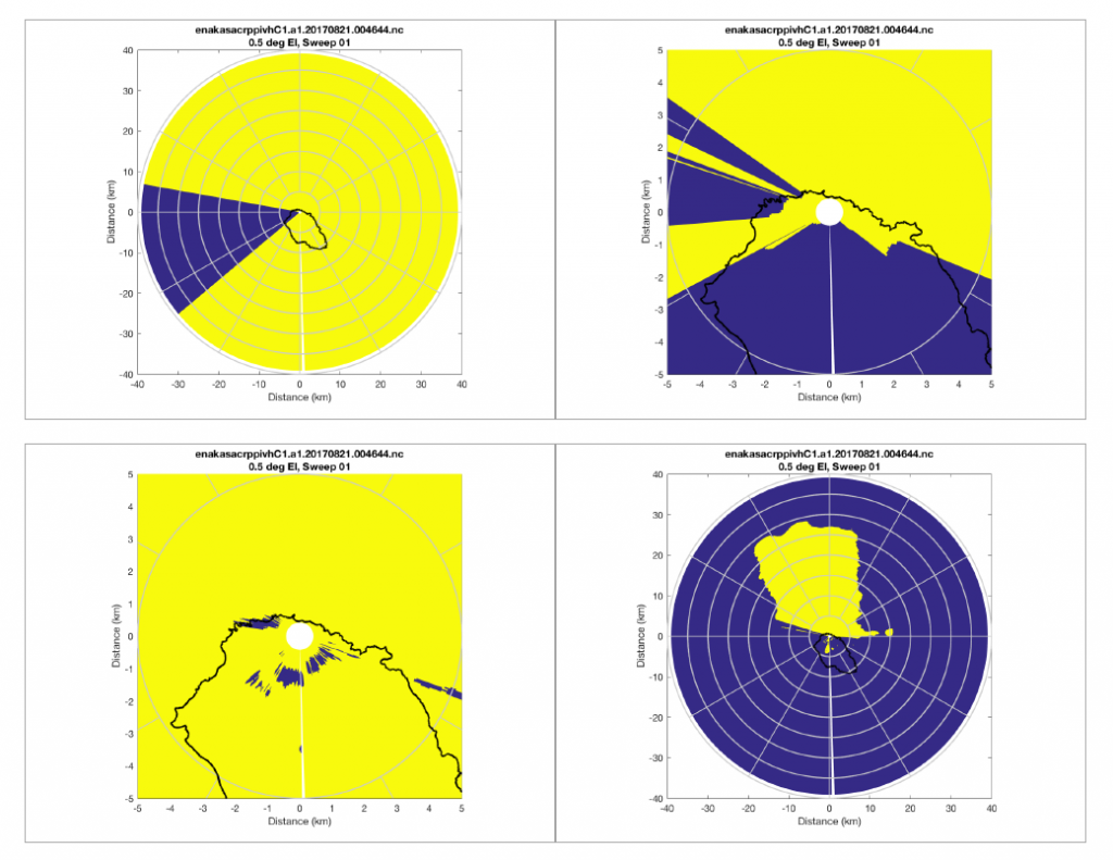
Five data quality masks were generated for the KASACR at the Atmospheric Radiation Measurement (ARM) Climate Research Facility’s Eastern North Atlantic (ENA) atmospheric observatory: clutter, blockage, blanking, and single- and dual-polarization significant echo. The masks can and should be used by end users to identify meteorological echoes and remove unwanted or poor-quality signals.
These masks were appended to the a1 datastreams (the first data collected) to create b1 files (data that have been improved from the first collection). The file format is netCDF and matches that of the a1 files, but with the addition of five fields relating to the data masks, as follows:
- mask_significant_echo: single-pol significant echo
- mask_copolar_variables: dual-pol significant echo
- mask_blanking_copolar_variables: transmitter blanking mask
- mask_blockage_copolar_variables: beam blockage mask
- mask_clutter_copolar_variables: ground clutter mask.
The example masks shown here are for plan position indicator (PPI) type images. The masks are also applied to range height indicator (RHI) and vertically pointing (VPT) type scans. The scan types are denoted by the datastream name, which is part of the file name.
The following datastreams (scan types) are included in the evaluation data set:
- b1: along-wind RHI
- b1: cross-wind RHI
- b1: hemispheric sky RHI
- b1: PPI volume (sector-type scan)
- b1: PPI volume
- b1: vertically pointing scan
- b1: vertically pointing scan–high resolution.
Scientists can begin using the masks now. In addition, the rest of the ACE-ENA KASACR campaign data are being processed and will be ready to use in 2018.
To share your experience or to ask questions, contact Bradley Isom or Nitin Bharadwaj, the lead developers for these evaluation data quality masks.
Access the data set in the ARM Data Center. (Go here to create an account to download the data.)
Reference:
Hubbert, JC, M Dixon, and SM Ellis. 2009. “Weather Radar Ground Clutter. Part II: Real-Time Identification and Filtering.” Journal of Atmospheric and Oceanic Technology 26: 1181–1197.
The ARM Climate Research Facility is a DOE Office of Science user facility. The ARM Facility is operated by nine DOE national laboratories.
Follow Us:


Keep up with the Atmospheric Observer
Updates on ARM news, events, and opportunities delivered to your inbox
ARM User Profile
ARM welcomes users from all institutions and nations. A free ARM user account is needed to access ARM data.


