

LASSO Case Study: Regional Weather Simulations Get a Look
Published: 23 July 2018
Researchers develop and test a new parameterization of the boundary layer
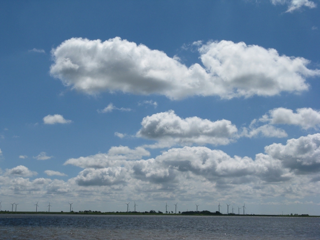
In the summer of 1999, boundary layer modeler Wayne Angevine was part of a project investigating air quality in Nashville, Tennessee. On most days, a layer of shallow cumulus clouds blanketed the sky over the city.
Angevine and other researchers noticed that these puffy, rain-free clouds had a significant effect on the vertical transport of urban emissions into the air.
From that observation, says Angevine, “it was obvious that we needed to model these cloud layers.” He has since been part of an effort to do just that.
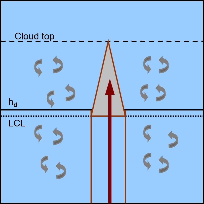
Shallow cumulus clouds, or cumuli, inhabit the boundary layer, the lower portion of the atmosphere that is the interface between the Earth’s surface and the air. It contains turbulent eddies that do not often occur at higher altitudes.
Shallow cumuli themselves house these vast eddies, which vertically transport heat and moisture. In turn, these clouds have a critical influence on temperature, solar irradiance, and storm generation.
For all these reasons, it is important to represent shallow cumuli well in mesoscale (regional) weather models. Getting the numerical simulations right means weather predictions stay accurate. It also means the same models will provide good estimates of sunshine and wind for renewable energy providers.
Despite their importance, shallow cumuli are a challenge to represent in numerical global-scale models as well as in weather prediction models, which are dominated in the United States by the commonly used Weather Research and Forecasting (WRF) model.
Modeling Shallow Cumulus

Today, Angevine is a research scientist in the chemical sciences division of the Earth System Research Laboratory (ESRL), an arm of the National Oceanic and Atmospheric Administration (NOAA) in Boulder, Colorado. He is also a member of the Cooperative Institute for Research in Environmental Sciences (CIRES), a partnership between NOAA and the University of Colorado, Boulder.
Angevine is lead author of a manuscript submitted to the journal Monthly Weather Review that describes improvements to the physics schemes embedded in the WRF model. The researchers say these improvements will sharpen the representation of shallow cumuli, particularly over land.
The paper is unique because it employs a year-old U.S. Department of Energy (DOE) project called the Large-Eddy Simulation (LES) ARM Symbiotic Simulation and Observation (LASSO) workflow.
Large-eddy simulations mathematically model turbulence in the cloudy boundary layer over areas 15 to 25 kilometers wide.
“LES has allowed us to do parameterization development for years now,” says Angevine.
However, experts say, LES is used most often for idealized simulations rather than real-world conditions.
“ARM” is a reference to the creator of LASSO and the origin of the observational data it depends on: DOE’s Atmospheric Radiation Measurement (ARM) user facility, which manages mobile and fixed observatories in critical regions of the world to gather, process, and archive atmospheric data.
Figuring Flux

Angevine and his co-authors isolated and intensively assessed the effect of their revised parameterization, which uses the eddy-diffusivity/mass-flux (EDMF) approach.
Mass flux is the turbulent transport of aerosols (tiny particles in the air) and other cloud chemicals from the bottom of the structure to the top.
EDMF takes into account nonlocal transport within clouds, beneath clouds, and in cloud-free boundary layers. Unlike the local diffusivity scheme used in some models, EDMF more accurately represents the size of the turbulent eddies that diffuse water, ice, and chemicals through the entire depth of shallow cumuli, top to bottom.
The researchers paired EDMF with the Mellor-Yamada-Nakanishi-Niino (MYNN) boundary layer scheme to arrive at the new parameterization of shallow cumuli they call MYNN-EDMF. (MYNN, a standard scheme in the WRF model since 2009, is a frequent target of software improvements.)
For comparison, the authors also include the older, simpler total energy mass flux (TEMF) scheme, which represents just a single cloud and a single updraft starting at the surface.
Angevine has been periodically working on TEMF since shortly after his observations in Nashville, often as a way to improve models of the vertical mixing of pollutants. The latest version, he says, “is more robust and stable.”
The draft paper is co-authored by two other NOAA-CIRES scientists (Joseph Olson and Jaymes Kenyon), as well as by collaborators from Pacific Northwest National Laboratory (William Gustafson), Brookhaven National Laboratory (Satoshi Endo), and the Jet Propulsion Laboratory at the California Institute of Technology (Kay Suselj).
Looping in LASSO Cases
LASSO is a proxy for conditions on a high-resolution meteorological scale. It also simplifies data discovery and analysis. LASSO case studies—bundled into packages of data—ease metadata searches, present parameters on a common grid, and include evaluative skill scores and diagnostics.
Within the LASSO framework, LES is combined with ARM observational data of atmospheric conditions and land-atmosphere exchange processes from ARM’s Southern Great Plains atmospheric observatory. LES then becomes part of a hybrid estimate of reality that samples a wide range of observed conditions.
The case studies, which currently relate to low clouds, represent differing conditions within a single day, with each day containing many different simulations.
“Somebody else had to put in the hard work of finding the right days where there were significant cloud fields, and then running the LES model,” says Angevine, in praise of LASSO. “It gave us a bunch of free, well-tested case studies.”
The first LASSO case studies, known as Alpha 1, are based on 2015 Southern Great Plains data. For their coming paper, Angevine and his co-authors chose five days, and then three simulations from within each day. For simplicity, they chose simulations with the same boundary conditions and other factors.
After converting the data to feed into a single-column WRF model, the researchers treated each of the 15 simulations independently. The goal was to match the single-column results with those from LES, and then to arrive at similar cloud properties.
Angevine called the results “quite amazing,” while acknowledging that it took “considerable tuning.”
For testing new parameterizations, he adds, the large number of cases available through LASSO “gives us more confidence that we have accounted for a wider range of possible scenarios.”
Going Operational
Olson says “about 90 percent” of the parameterization described in the paper will be operational by mid-July.
The new parameterization for mass flux in shallow cumuli is already part of the next-generation Rapid Refresh (RAP) and High Resolution Rapid Refresh (HRRR) forecast systems, which both use WRF as the model forecast component. These models are run at the National Centers for Environmental Prediction (NCEP), which is NOAA’s operational modeling arm at the National Weather Service (NWS), where such software is maintained and run operationally.
The main customers for the improved model, as always, will be the Federal Aviation Administration, which needs a robust way to forecast safe-weather flight trajectories, and the NWS, which provides important everyday weather forecasts for the nation.
“That’s why I got into the business to begin with—to make weather forecasts better,” says Olson. “It’s not just a job for me.”
The updated RAP and HRRR systems will also be used for severe weather forecasts, wind energy projections, and solar predictions.
Olson and others developed and tested MYNN-EDMF for a year before last summer, when operations at NCEP put it under what modelers call “code freeze.” From there, it was tested further on NCEP supercomputers.
In this way—intensive testing, code freezes, and handoffs to operations for more testing—upgrades to RAP and HRRR are made every two years or so. Meanwhile, developers such as Olson are always working on the next improved iteration.
In the weather forecasting world, the next best thing is always around the corner and new ideas and innovations always threaten to overtake older ones, says Olson. “It’s a very competitive scientific world.”
There is ultimately just one desired result, however: improved weather forecasts for the nation.
“It’s a contribution to society,” says Olson of his job to revamp forecast models, new parameterizations and all. “I’m doing something for everyday life.”
The ARM Climate Research Facility is a DOE Office of Science user facility. The ARM Facility is operated by nine DOE national laboratories.
Follow Us:


Keep up with the Atmospheric Observer
Updates on ARM news, events, and opportunities delivered to your inbox
ARM User Profile
ARM welcomes users from all institutions and nations. A free ARM user account is needed to access ARM data.


