

Field Campaign’s Unique Surface Views Could Provide New Clues about Land-Atmosphere Interactions
Published: 15 July 2017
In August, when the month-long Land-Atmosphere Feedback Experiment (LAFE) kicks off at the Atmospheric Radiation Measurement (ARM) Facility’s Southern Great Plains (SGP) megasite, researchers will get a unique look at how the atmospheric boundary layer responds to what is directly below it.
“We can scan down low with our instruments to the surface, which will be done for the first time,” says LAFE principal investigator Volker Wulfmeyer, chair of physics and meteorology at the University of Hohenheim in Stuttgart, Germany. “This is a unique experiment because we are able to observe the evolution of atmospheric properties to the different land covers in three dimensions.”
Wulfmeyer says LAFE researchers aim to advance earth process modeling by studying interactions between land at the SGP site and the atmospheric boundary layer, which is the lowest part of the atmosphere. This layer controls the exchange of momentum, energy, and water between the land and atmosphere.
“Due to complex feedback processes between the soil, vegetation, and the atmosphere,” Wulfmeyer says, “it is essential to observe variables such as soil moisture, evapotranspiration, as well as atmospheric moisture and temperature simultaneously in order to improve their representation in models.”
From the Ground Up
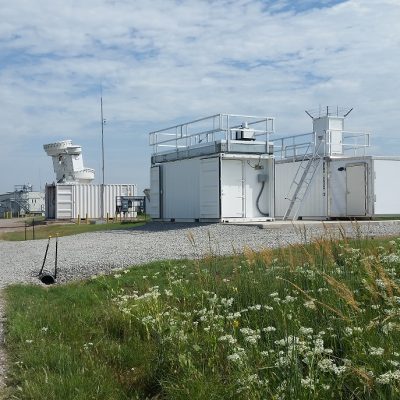
To achieve this, LAFE will use a collection of remote-sensing systems to measure moisture, temperature, and horizontal wind mean, gradient, and turbulence profiles. These systems will scan from the surface throughout the atmospheric boundary layer up to 3,000 meters.
Surfaces to be sampled include 3- to 4-foot-tall native grasses that haven’t been cut for decades, pasture fields, and recently harvested farm fields.
Improving the representation of turbulence in the boundary layer is a key objective of LAFE, says co-investigator Dave Turner of the National Oceanic and Atmospheric Administration (NOAA) Earth System Research Laboratory. Conventionally, scientists have collected data sets from towers and applied physical principles to help describe how the turbulence should look in a model.
“Using these scanning lidar systems is a very unique approach to do the same thing,” Turner says. “But instead of just making measurements at one or two levels and then trying to guess what the turbulence looks like through the whole boundary layer, we’ll be able to observe it through the whole boundary layer.”
Says Wulfmeyer: “Currently, the moisture and temperature distributions in the atmospheric boundary layer must be considered as unknown territory in atmospheric sciences. Therefore, the observation and understanding of moisture and temperature comes first in order to achieve a better simulation of the onset and evolution of clouds and precipitation.”
Systematic Teamwork
LAFE will use SGP instruments such as the water vapor and temperature Raman lidar, and wind Doppler lidar. The University of Hohenheim, National Center for Atmospheric Research, and NOAA Earth System Research Laboratory will contribute additional lidar systems.
Portable facilities from the University of Wisconsin-Madison, University of Oklahoma, and NOAA National Severe Storms Laboratory will supplement SGP instruments with two vertically pointing atmospheric emitted radiance interferometers and two Doppler lidar systems.
Seeking more information about the diversity of fluxes at the SGP site, LAFE researchers are setting up four flux stations over different land covers. The field campaign also plans to incorporate an unmanned aerial system (UAS) operated by NOAA’s Air Resources Laboratory (ARL).
“The UAS would primarily measure temperature, humidity, and winds with the goal of getting some measure of the spatial inhomogeneity around our observation site,” Turner says. “But ARL has been experimenting with a new method of measuring sensible heat flux with a UAS, and thus we would both validate their new technique and get some idea of how the sensible heat flux varies over the LAFE domain.”
Marquette University, Cleveland State University, NASA, the University of Hannover (Germany), the Federal Ministry of Education and Research (Germany), and the Cooperative Institute for Research in Environmental Sciences are providing additional support to the research team.
Getting cooperation from so many institutions—the ARM Facility in particular—is crucial for a field campaign like this.
“The ARM site, for instance, is special with respect to the vertical observing instruments like the Raman lidar, which is located there,” Wulfmeyer says. “It’s just the perfect location to get started with these types of instruments. We need the vertical pointing instruments, we need the scanning instruments, we need the land-surface observations.
“If we can put this all together, then we can expect progress in atmospheric and earth system sciences.”
The ARM Climate Research Facility is a DOE Office of Science user facility. The ARM Facility is operated by nine DOE national laboratories, including Argonne National Laboratory.
Follow Us:


Keep up with the Atmospheric Observer
Updates on ARM news, events, and opportunities delivered to your inbox
ARM User Profile
ARM welcomes users from all institutions and nations. A free ARM user account is needed to access ARM data.


