

ARM Adds to Its Data Toolbox for the Scientific Community
Published: 20 April 2020
Users working with atmospheric time-series data can get help from a new open-source toolkit
The Atmospheric Radiation Measurement (ARM) user facility maintains a data archive that spans almost three decades, 400-plus instrument systems, and diverse climate regimes around the world.
“We wanted to create a platform where science users could share code with ARM and ARM could share code with the science users as well.”
Adam Theisen, ARM instrument operations manager
ARM also strives to keep making its atmospheric data more accessible for the scientific community. To help users working with time-based data sets from ARM and other long-term measurement networks, ARM supports the open-source Atmospheric data Community Toolkit (ACT). This library provides code for all parts of the data processing life cycle—discovery, input/output, quality control, corrections, retrievals, visualization, and analysis—and anyone can use it or add to it.
“We wanted to create a platform where science users could share code with ARM and ARM could share code with the science users as well,” says Adam Theisen, ARM instrument operations manager from Argonne National Laboratory in Illinois.
ACT developers leveraged the Python ARM Radar Toolkit (Py-ART) model, lessons learned, and technology advancements in creating the framework of the ACT repository. Py-ART developers, the ARM Data Quality Office, and ARM Data Services staff at Oak Ridge National Laboratory in Tennessee have been key partners and contributors toward the development and use of the code in ACT.
“We saw that the radar need was already met,” says Theisen, “but there is still a whole lot more that we could branch out and hopefully develop uses for.”
ACT Springs Into Action
Starting in early 2019, Theisen worked with Argonne colleagues Scott Collis, Zach Sherman, Bobby Jackson, Jason Hemedinger, and Nicki Hickmon, ARM associate director for operations, to develop ACT.
The team collaborated with the ARM Data Quality Office, which reviews and characterizes the quality of ARM data. “They’ve been phenomenal partners in developing a lot of the code that’s in here as well,” says Theisen.
The team also worked with ARM Data Center staff to pull in code for easily downloading data from ARM’s Data Live Web Service.
ACT has already factored into some important data revisions and streamlining of processes.
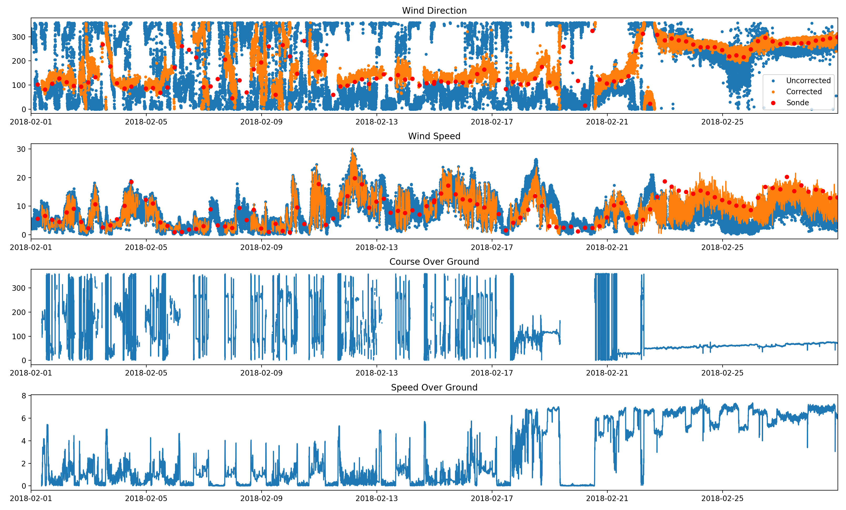
During the 2017‒2018 Measurements of Aerosols, Radiation, and Clouds over the Southern Ocean (MARCUS) field campaign, ARM instruments collected measurements on the Aurora Australis supply vessel as it traveled between Australia and Antarctica. When a user noted that wind speed and wind direction data were not corrected for ship motion as the files indicated, the ACT team got to work.
“We were able to quickly put together some code, put it into ACT, and give them an example of how they could potentially correct the wind for ship motion,” says Theisen. ARM also updated the metadata in the files to show that the wind direction was relative to the direction in which the ship was pointing.
Meanwhile, Ken Kehoe from the ARM Data Quality Office provided code that allows ACT users to get sea surface temperatures based on infrared thermometer data from marine campaigns.
“Someone in the community has coded up a retrieval before, and if we can get it out there, we can reduce a lot of the duplication of effort across the community and even ARM as well,” says Theisen.
Help ACT Grow
The ACT team seeks contributions from users, particularly corrections and retrievals. To add to ACT or to give feedback, contact Theisen.
Follow Us:


Keep up with the Atmospheric Observer
Updates on ARM news, events, and opportunities delivered to your inbox
ARM User Profile
ARM welcomes users from all institutions and nations. A free ARM user account is needed to access ARM data.


