

LASSO Case Study: Tapping ARM’s Doppler Lidars
Published: 6 November 2018
To improve models, researchers tap Doppler lidars to estimate critical cloud-based updrafts and downdrafts that carry heat and moisture
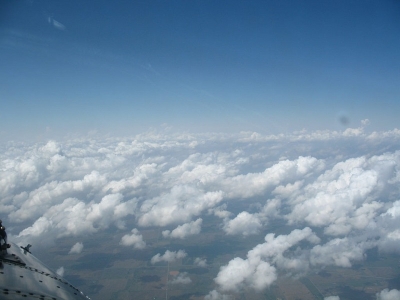
Cumulus clouds, low and rain-free, get their name from the Latin word for “heap.” With flat bases and puffy upper surfaces, such clouds appear to bubble into the sky, turning grey at the bottom and brilliant white at the top.
How these clouds form is of great interest to scientists. They reflect a lot of sunlight and play an important role in how heat and water vapor are distributed in the lower atmosphere, impacting surface temperature, and soil moisture.
These clouds and others are formed when heat and moisture rise from the Earth’s surface into the cooler atmosphere. Updrafts are the engine of this movement, along with the downward and mixing motion created by competing downdrafts.
“Shallow cumulus clouds are the visual manifestation of the updrafts,” explains Pavlos Kollias, an atmospheric scientist at Brookhaven National Laboratory (BNL) on Long Island, New York. (He also has a joint appointment at nearby Stony Brook University.)
Early studies of how such clouds work used profiling cloud radars. These instruments, typically deployed at ground sites, take rapid high-resolution measurements of conditions (including wind velocity) in a narrow column right above the radar.
Kollias recalled his graduate studies in shallow cumulus at the University of Miami with mentor Bruce Albrecht. “Back then,” he says, “using a profiling radar was all we could hope for.”
Today, cloud-profiling instrumentation is prominently sited at the Southern Great Plains (SGP) atmospheric observatory, operated by the U.S. Department of Energy’s (DOE’s) Atmospheric Radiation Measurement (ARM) user facility.
Pinning Down Vertical Velocity

Kollias is part of a BNL-based team that is expanding the instruments used by including Doppler lidar to improve the evaluation of models. This leads to better estimates of the magnitude and range of cloud-forming updrafts and downdrafts at and below cloud base.
The vertical velocity at cloud base, he says, “is a very important parameter” for understanding the evolution of the atmosphere’s boundary layer and cloud life cycles. More accurately representing vertical velocity and its interaction with clouds would improve the predictive accuracy of earth system models.
“The cloud base is where clouds are generated and a lot of energy goes into it,” says his colleague, Satoshi Endo, a scientific associate at BNL whose expertise is high-resolution modeling, cloud physics, and boundary-layer meteorology.
That makes “cloud-base vertical velocity an essential property for understanding the formation and development of clouds,” he adds. “It also quantifies the exchange of air between the boundary layer and the atmosphere above, and represents vertical transport by clouds.”
Yet models and observations often do not agree on the vertical velocity at cloud base.
The BNL researchers think improving the modeling of the shell at the edge of these clouds could at least partly explain why observations and models vary.
Adding Doppler Lidar
Kollias and colleagues at BNL and elsewhere are bringing Doppler lidars into the measurement and model-evaluation scheme. They think its measurement strengths could help close the gap between models and observations in characterizing the cloud base.
The primary team is a cross-disciplinary group of observationalists and modelers. Endo and Damao Zhang, a research associate who studies cloud physical properties and specializes in retrieval algorithms, are doing the heavy lifting.
Rounding out the main team with Kollias is BNL’s Andrew Vogelmann, the project’s principal investigator.
Doppler lidar is a remote-sensing technology similar to radar that sends a laser pulse into the air and looks to see what light is scattered back by small particles. This information is then used analytically to see if the particles are moving towards or away from the device, among other details.
Unlike radar, Doppler lidar can “see” winds when there are no clouds; it senses how aerosols scatter and interprets those signals.
And unlike radar, lidar is also not confused by atmospheric biota (chiefly insects).
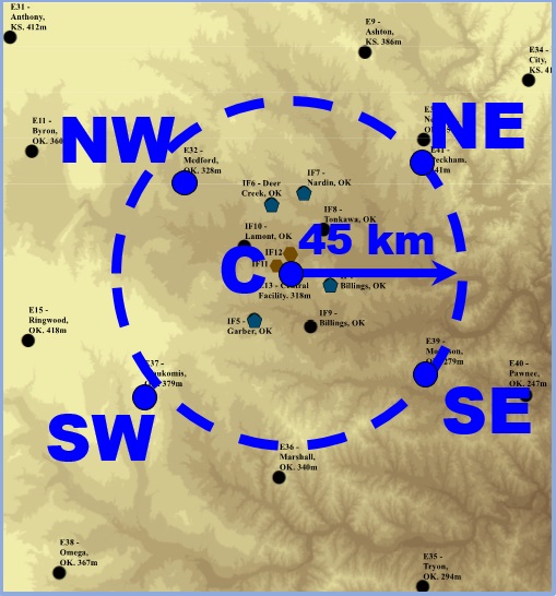
Bringing in concentrated Doppler lidar data became possible two years ago. That’s when ARM added a network of four lidars in a ring around one already running at SGP’s Central Facility. The lidar network is arrayed in the northwest, northeast, southwest, and southeast corners of an area 90 kilometers (56 miles) in diameter.
Herding Cloud ‘Cattle’
The BNL team’s efforts are part of DOE’s Climate Model Development and Validation (CMDV) “Coupling Mechanistically the Convective Motions and Cloud Macrophysics in a Climate Model” (CM4) project.
The objective of CM4 is to dramatically improve the representation of shallow convection through advanced observational analyses of shallow cumulus. CM4 is developing advanced methods for modeling parameterization.
The team lead for CMDV-CM4 is David Romps at Lawrence Berkeley National Laboratory (LBNL). His co-investigators are from BNL (including Kollias, Vogelmann, and meteorologist Michael Jensen), along with collaborators from the University of Washington and the University of Texas, Austin.
The project, supported by DOE’s Atmospheric System Research program, was officially launched in 2016. It uses a new suite of instruments in the search for insights into low-cloud behavior. That suite now includes SGP’s enhanced array of Doppler lidars.
The target of the improved representation is DOE’s Energy Exascale Earth System Model (E3SM), which emphasizes modeling the full earth system with an eye to exploiting DOE’s next-generation exascale computing.
Representing convective motion in models is difficult because updrafts and downdrafts are complex turbulent eddies that bubble up and down.
Think of turbulent clouds forming upward as a “herd of cattle heading in the same direction,” says Vogelmann, “though each cow might be moving slightly differently than the others.”
Adding LASSO
Vogelmann and his team are grappling with how to represent cloud-base vertical velocity by evaluating the difference between observations and simulations.
Doppler lidar sited at SGP gave Vogelmann and the other researchers one way to rope data on that turbulent herd of cattle busy forming clouds.
From there, the BNL team formulated an expanded strategy for assessing models by adding in the newly available archive of ARM routine large-eddy simulations (LES) that are designed to complement ARM observations.
The simulation library, based on daily routine measurements at SGP, is called LASSO, which stands for LES ARM Symbiotic Simulation and Observation workflow.
LASSO makes 3D modeled cloud fields, statistics, and model inputs easily accessible, allowing researchers to test models by using statistical approaches beyond single cases.
Its routine model simulations capture the activity of shallow cumulus clouds in LES conditions at SGP—the kind of robust, observation-based simulations modelers need. The data are packaged in data bundles from a library of cloudy days carefully chosen by LASSO administrators.
LASSO also makes getting this data convenient.
“That’s not trivial,” says Vogelmann, since it takes so much time to assemble a similar data bundle for a single day, much less a series of days. “There’s a lot of stuff going on in the background.”
He is co-principal investigator on the LASSO project, joined by William Gustafson of Pacific Northwest National Laboratory.
Using LASSO data bundles beats setting up a model based on “just a cool-looking day” that may not represent the sky environment well in a model, says Vogelmann. “You need to drive the model with a realistic atmosphere.”
Lidar-LASSO Synergy
Vogelmann and the others had a glimmer of what they might do a year ago. It has gradually come into focus since then during a few public talks, starting with one last fall at the American Geophysical Union meeting. Most recently, they presented a talk at the July American Meteorological Society Cloud Physics meeting.
There is no paper yet, says Vogelmann (one is in the works), but the response to the talks from the modeling community has been good so far. That includes interest in what he calls the “amazingly robust” results and how well “the environment is put into the model.”
Based on the five Doppler lidars, the researchers set out to observe statistics of cloud-base vertical velocity at SGP and to test LES using LASSO.
They used SGP lidar observations from May to September 2016 and 2017, identified fair-weather shallow cumuli, and both observed and simulated cloud-base vertical velocity.
Their LASSO simulations drew on a series of 2016 cases run with the community Weather Research and Forecasting (WRF) model within a 14.5-kilometer domain of sky.
Additional work ahead includes checking vertical velocity observations from aircraft research campaigns and testing interactive land-surface models.
“We have invested a lot of time understanding and analyzing the observations,” says Kollias, summing up. “The ongoing effort is by no means discouraging. It is all we hoped for.”
Follow Us:


Keep up with the Atmospheric Observer
Updates on ARM news, events, and opportunities delivered to your inbox
ARM User Profile
ARM welcomes users from all institutions and nations. A free ARM user account is needed to access ARM data.


