

ENA’s Newest Instruments Support Most Extensive Marine Cloud Data Set
Published: 8 February 2016

An elderly farmer sings in Portuguese as his donkey carries him down the steep cobbled roads to a village below. Hydrangeas and cedar perfume the air around bubbling volcanic geysers and lagoons. A thousand miles from anywhere, Graciosa Island hosts some of the world’s most advanced atmospheric instrumentation that scientists rely on to advance climate science.
Graciosa is part of the Azores Archipelago (an autonomous region of Portugal) in the middle of the North Atlantic Ocean. Its temperate, subtropical climate with mild annual oscillations make the island—home to only 4,000 people—an ideal place to study the marine stratocumulus clouds that prevail over the island. Response of these stratocumulus clouds to changes in atmospheric greenhouse gases and aerosols is a major source of uncertainty in global climate models.
Here, the U.S. Department of Energy Atmospheric Radiation Measurement (ARM) Climate Research Facility, in collaboration with the local government and university, hosts one of its observation facilities, the Eastern North Atlantic (ENA) site. ENA operations began in September 2013 following a previous successful deployment on the island that ended in 2010.
Instruments sample the transition from an overcast stratocumulus regime in the spring to the broken trade cumulus regime in the summer. ENA’s baseline suite of instruments monitors the interaction of clouds, aerosols, and precipitation in this region and has provided the most extensive and comprehensive data set of marine boundary layer clouds to date.
Site Improvements
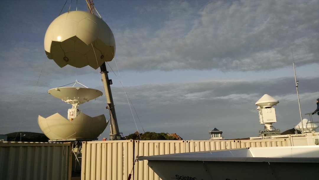
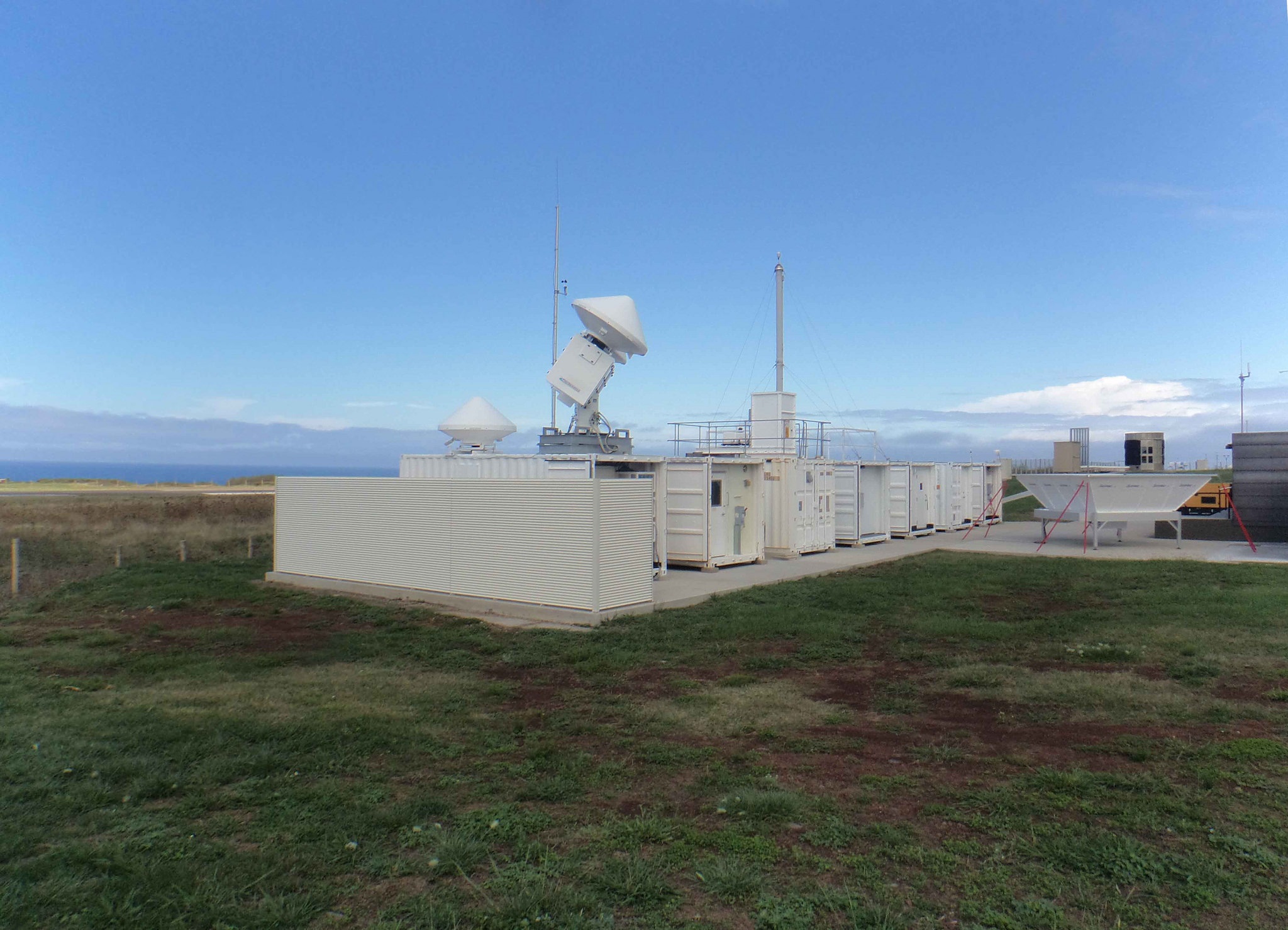
Recently, the ENA site was improved with the installation of new instruments to collect data: aerosol and trace gas systems, atmospheric and boundary state systems, radars and lidars, radiometers, a hydrogen generation system, remote balloon launcher, scanning ARM cloud radar, and a two-dimensional video disdrometer.
In September 2015, the ARM ENA operations team installed a Raman lidar to measure the vertical profiles of water-vapor mixing ratio and several cloud- and aerosol-related quantities. The team recently installed the X-band scanning ARM precipitation radar (X-SAPR), a dual-polarization Doppler weather radar that was tested in late January.
“These new instruments complete the last of the large instruments at the site,” said ENA Operations Lead Paul Ortega from Los Alamos National Laboratory, which manages and operates the ENA. “Also, new technician Bruno Cunha, a Graciosa local who works with lead technician Carlos Sousa, is a great addition to our team who has impressed us with his aptitude and ability to work with instrument mentors to resolve instrumentation problems and ensure all instruments are performing well.”
Science Happening Now
Most ARM sites, including the ENA, host short-term field campaigns or guest instrument deployments proposed by the science community, in addition to long-term baseline data-collection campaigns. The following are some of the guest research campaigns that the ENA supports:
In September 2014, a study began to analyze the vertical component of the atmospheric electric field and its relation with the concentration of aerosols and natural radioactivity (mainly radon) in the lower troposphere. Led by Hugo Silva and Portugal’s Evora Geophysics Centre (University of Evora), this 5-year study will provide an important data set from the subtropical marine boundary layer where climate models show the greatest discrepancy in cloud responses.
Dave Tobin from the University of Wisconsin-Madison led a satellite system validation campaign that covered most of last year. This field campaign used satellite overpass coincident radiosonde launches to help validate the U.S. National Polar-orbiting Operational Environmental Satellite System (NPOESS) that is being developed to monitor global environmental conditions and collect and disseminate data related to weather, atmosphere, oceans, land and near-space environment.
A gamma-radiation-monitoring campaign, led by Susana Barbosa at Portugal’s Institute for Systems and Computer Engineering, Technology, and Science, began last spring and runs through early 2018. This gamma radiation monitoring campaign studies the temporal variability of the concentration of the noble gas radon (Rn-222), aiming to examine how it’s influenced by meteorological conditions, how it impacts the local atmospheric electric field, and its association with the atmosphere’s ionization and aerosol’s concentration.
Beginning in June 2016, Brookhaven National Laboratory scientist Jian Wang will lead a 9-month aerosol and cloud aircraft field campaign supplementing ground-based data with the ARM Aerial Facility Gulfstream-159 (G-1) twin turboprop aircraft, operated by the Pacific Northwest National Laboratory for DOE. Wang’s research will provide low-cloud data to support global climate models. According to Wang, global climate models lack cloud data due to inadequate observations of their microphysical and macrophysical structures, radiative effects, and associated aerosol distribution and budget in regions where the aerosol impact is the greatest.
Watch for an ARM virtual tour of ENA to be released later this year.
# # #
The ARM Climate Research Facility is a national scientific user facility funded through the U.S. Department of Energy’s Office of Science. The ARM Facility is operated by nine Department of Energy national laboratories, including Los Alamos National Laboratory, which manages the Eastern North Atlantic site.
The ARM Climate Research Facility is a DOE Office of Science user facility. The ARM Facility is operated by nine DOE national laboratories, including .
Follow Us:


Keep up with the Atmospheric Observer
Updates on ARM news, events, and opportunities delivered to your inbox
ARM User Profile
ARM welcomes users from all institutions and nations. A free ARM user account is needed to access ARM data.


