

New Data Set Available From COMBLE Campaign
Published: 13 June 2022
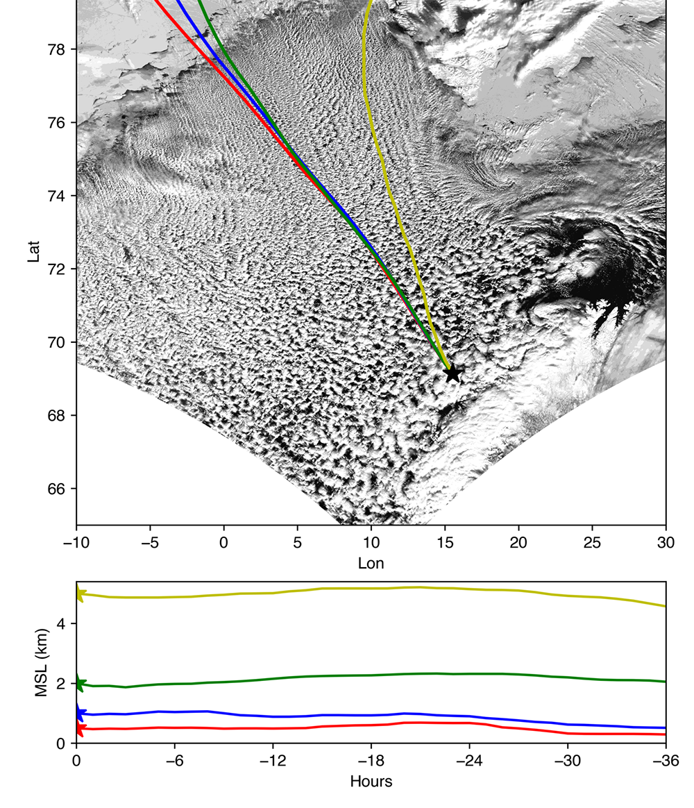
Now available in the Atmospheric Radiation Measurement (ARM) Data Center are calculated back trajectories for identified cold-air outbreak cases from the Cold-Air Outbreaks in the Marine Boundary Layer Experiment (COMBLE). Back trajectories are commonly used to determine the origin of air masses observed at a given location.
The ARM user facility conducted the COMBLE field campaign from December 2019 through May 2020 at two sites in northern Norway. An ARM Mobile Facility collected data near Andenes, while a smaller instrument site operated on Bear Island. Researchers reported 34 days of cold-air outbreak conditions near Andenes and 38 days on Bear Island during COMBLE.
For every hour of cold-air outbreak cases identified from interpolated sounding by Geerts et al. (2022) at either site, a 36-hour back trajectory was calculated using the NOAA Hybrid Single-Particle Lagrangian Integrated Trajectory (HYSPLIT) model. For air masses at specific elevations at the endpoint where the back trajectories were initiated, their historical locations (latitude, longitude, and altitude) in the past 36 hours were computed.
Three meteorological data sets were used as inputs to HYSPLIT:
- Global Forecast System (GFS) 0.25 degree
- Global Data Assimilation System (GDAS) 1 degree
- National Centers for Environmental Prediction/National Center for Atmospheric Research (NCEP/NCAR) Reanalysis.
The back trajectories were calculated for four endpoint elevations: 500 meters, 1,000 meters, 2,000 meters, and 5,000 meters.
Coordinates (latitudes, longitudes, and altitudes) for each hour of the trajectory are reported in the ASCII files.
COMBLE back trajectory data from December 1, 2019, to March 27, 2020, are ready to use now. The U.S. Department of Energy’s Atmospheric System Research (ASR) supported work on these data through the Integrated Cloud, Land-surface, and Aerosol System Study (ICLASS) Science Focus Area.
Access the data in the ARM Data Center. (Go here to create an account to download the data.)
To ask questions or provide feedback about the data, please contact Peng Wu or Mikhail Ovchinnikov.
When citing the data set, please use doi:10.5439/1843763.
Reference: Geerts B, S Giangrande, G McFarquhar, L Xue, S Abel, J Comstock, S Crewell, P DeMott, K Ebell, P Field, T Hill, A Hunzinger, M Jensen, K Johnson, T Juliano, P Kollias, B Kosovic, C Lackner, E Luke, C Lüpkes, A Matthews, R Neggers, M Ovchinnikov, H Powers, M Shupe, T Spengler, B Swanson, M Tjernström, A Theisen, N Wales, Y Wang, M Wendisch, and P Wu. 2022. “The COMBLE campaign: a study of marine boundary-layer clouds in Arctic cold-air outbreaks.” Bulletin of the American Meteorological Society, 103(5):E1371-E1389, https://doi.org/10.1175/BAMS-D-21-0044.1.
Follow Us:


Keep up with the Atmospheric Observer
Updates on ARM news, events, and opportunities delivered to your inbox
ARM User Profile
ARM welcomes users from all institutions and nations. A free ARM user account is needed to access ARM data.


