

Updated: New Cloud Radar Products Available From COMBLE Campaign
Published: 20 July 2023
Editor’s note (July 20, 2023): A new KASACRGRIDRHI evaluation release for COMBLE, which uses b1-level calibrated HSRHI data as input, is now available. The output is a single c1-level netCDF file containing calibrated radar moments remapped onto a 2D Cartesian grid. Access the data from the ARM Data Center. To cite the c1-level data, please use doi:10.5439/1645175.
The Atmospheric Radiation Measurement (ARM) user facility released two new cloud radar value-added products (VAPs) from the 2019–2020 Cold-Air Outbreaks in the Marine Boundary Layer Experiment (COMBLE) in northern Norway.
With these VAPs, scientists can more easily use corrected observations from ARM scanning and vertically pointing cloud radars, and they can access hydrometeor masks and cloud boundaries from the entire COMBLE field campaign.
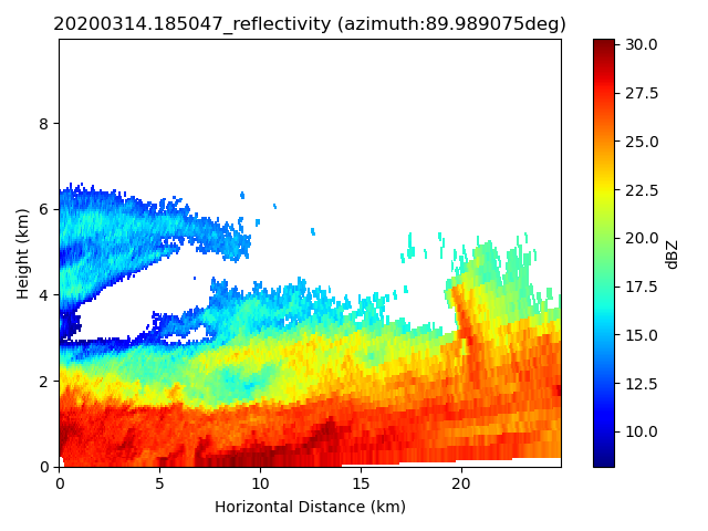
Scanning ARM Cloud Radar Grid (SACRGRID) VAPs provide radar moments from range-height indicator (RHI) scans on a Cartesian grid. A SACRGRID product for the Ka-Band Scanning ARM Cloud Radar—known as KASACRGRIDRHI—is now available from COMBLE.
The gridded radar moments include reflectivity, mean Doppler velocity, spectral width, signal-to-noise ratio, and differential phase. The moments are accompanied by a significant detection mask, linear depolarization ratio, and copolar-to-crosspolar correlation coefficient.
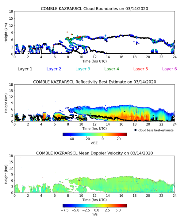
Also available from COMBLE is the Ka-Band ARM Zenith Radar Active Remote Sensing of CLouds (KAZRARSCL) VAP.
KAZRARSCL combines KAZR, micropulse lidar, ceilometer, sounding, and microwave radiometer input observations to produce two datastreams. The arsclkazr1kollias datastream provides best-estimate radar reflectivities, mean Doppler velocities, spectral widths, and a significant detection mask in time and height. This datastream also provides up to 10 layers of cloud boundaries (cloud base and cloud top) and best-estimate cloud base. The smaller arsclkazrbnd1kollias datastream provides only cloud boundaries and cloud base.
KAZRARSCL and KASACRGRIDRHI are available from December 2019 through May 2020 for the COMBLE ARM Mobile Facility deployment near Andenes, Norway.
Currently an evaluation product, KASACRGRIDRHI remaps RHI scans to a Cartesian grid. During COMBLE, the RHI scan used was the Hemispheric Sky RHI (HSRHI), consisting of consecutive horizon-to-vertical scans (elevations 0–90 degrees) at azimuths of 0, 30, 60, and 90 degrees.
Input data are a1-level uncalibrated HSRHI data. A nearest neighbor algorithm is used for gridding, with a censor mask applied. Gaseous attenuation correction is also applied for the Ka-band radars—KASACR and KAZR—before gridding.
The output is a single netCDF file containing calibrated radar moments remapped onto a two-dimensional (2D) Cartesian grid.
KAZRARSCL is available in daily files. It provides vertical profiles every four seconds from approximately 160 meters above ground level up to 18 kilometers, with 30-meter height resolution.
The new COMBLE cloud radar VAPs are available to use now. More information about the VAPs can be found on the web pages for KASACRGRIDRHI and KAZRARSCL.
To ask questions, provide feedback, or report data problems, please contact Meng Wang or Scott Giangrande for KASACRGRIDRHI, and Karen Johnson or Scott Giangrande for KAZRARSCL.
Access the data sets for KASACRGRIDRHI and KAZRARSCL in the ARM Data Center. (Go here to create an account to download the data.)
KASACRGRIDRHI data can be referenced as doi:10.5439/1578283.
To cite the KAZRARSCL data, please use doi:10.5439/1393437 for arsclkazr1kollias and doi:10.5439/1393438 for arsclkazrbnd1kollias.
Follow Us:


Keep up with the Atmospheric Observer
Updates on ARM news, events, and opportunities delivered to your inbox
ARM User Profile
ARM welcomes users from all institutions and nations. A free ARM user account is needed to access ARM data.


