

ARM Data-Oriented Metrics and Diagnostics Package Updated
Published: 23 March 2021
New release will be used in E3SM diagnostics package
The Atmospheric Radiation Measurement (ARM) user facility provides high-frequency and long-term data sets to help develop and improve earth system models. A data-oriented metrics and diagnostics package called ARM-DIAGS—now in its second version—is designed to further facilitate the use of ground-based ARM measurements in model evaluation.
ARM-DIAGS includes data from ARM and the Coupled Model Intercomparison Project (CMIP) as well as a Python-based analysis toolkit for computation and visualization. The package can serve as an easy entry point for earth system modelers to compare their models with ARM data and supplementary CMIP data sets.
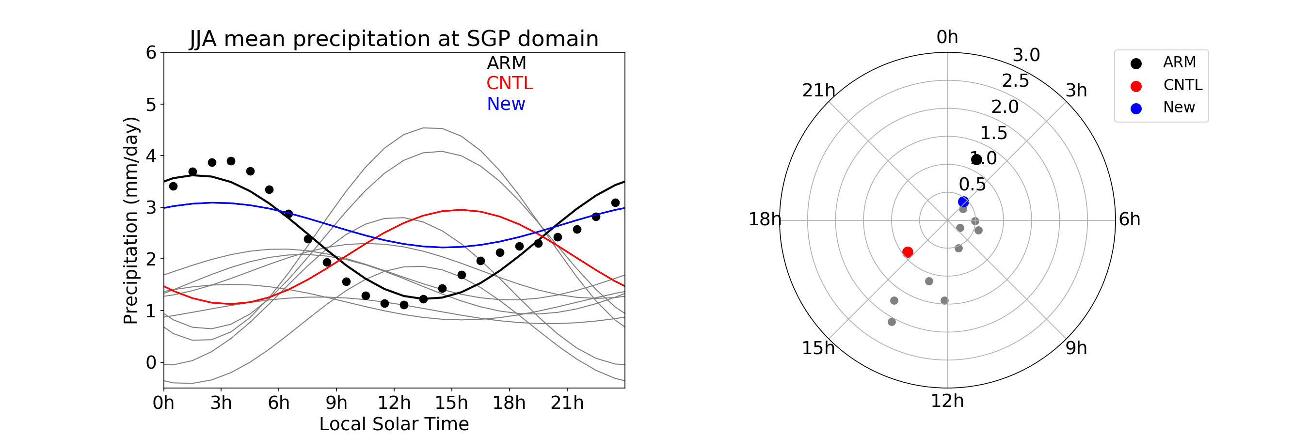
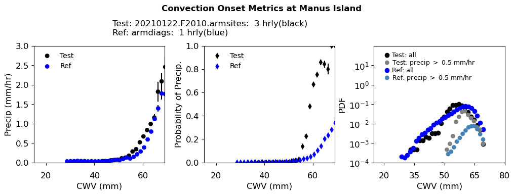
Version 2 of ARM-DIAGS expands the data availability from ARM’s Southern Great Plains atmospheric observatory (version 1) to include the North Slope of Alaska and Tropical Western Pacific atmospheric observatories. Convection onset metrics showing the statistical relationship between the precipitation rate and column water vapor are also implemented in version 2 of ARM-DIAGS.
Inside ARM-DIAGS
Data in ARM-DIAGS are derived from ARM Best Estimate (ARMBE) data products, ARM long-term continuous forcing data (VARANAL), ARM Cloud Retrieval Ensemble Data (ACRED), and other ARM value-added products for variables not included from the first three data sources.
The data package also includes simulation data from models participating in CMIP, which will allow earth system modeling groups to compare a new candidate version of their model with existing CMIP models.
Coming Soon: E3SM and Extending to More ARM Sites
One key model of interest for the ARM-DIAGS team is the Energy Exascale Earth System Model (E3SM) supported by the U.S. Department of Energy. Some ARM-DIAGS features were used in developing E3SM’s parameterization of key atmospheric physical processes.
Coming soon, a new version of E3SM’s diagnostics package (E3SM-Diags) integrates ARM-DIAGS version 2. This E3SM-Diags release will allow users to routinely test E3SM output at multiple ARM sites against climatology and time-series files generated from ARM data.
Most diagnostics suites in E3SM-Diags have focused so far on global analysis. Incorporating comprehensive analyses using observations from selected ARM locations from different climate regions will complement the current evaluation capability.
The new E3SM-Diags release will include the seasonal mean and annual cycle of a range of atmospheric variables from ARM observations, including surface air temperature, precipitation, radiation fluxes and surface turbulent fluxes, the metrics of convective onset, and the diurnal cycle of both cloud fraction and precipitation. These convection onset and diurnal cycle diagnostics will be run routinely to help the E3SM team evaluate the model’s convection schemes and particularly to understand how the parameters and related physical processes are represented in the model.
Learn more about ARM’s contributions to E3SM-Diags in this article on the E3SM website.
For the ARM-DIAGS team, future work includes extending ARM-DIAGS to ARM’s Eastern North Atlantic atmospheric observatory and ARM Mobile Facility deployments. CMIP6 data will be included as they become more available.
Learn More and Use ARM-DIAGS
More information about ARM-DIAGS can be found on the ARM Diagnostics for Climate Model Evaluation (ADCME) data source web page.
To ask questions, report data problems, or get specific ARM-DIAGS configurations for a model run, please contact Chengzhu Zhang, Cheng Tao, or Shaocheng Xie. More details about ARM-DIAGS are available in Zhang et al. 2020.
The ARM-DIAGS v2.0 analysis codes are publicly available through GitHub in the ARM User Facility project space. Analysis data include ARM observational data sets and reference CMIP5 Atmospheric Model Intercomparison Project (AMIP) data, which can be downloaded through the ARM Data Center. (Go here to create an account to download the data.)
Data can be referenced as doi:10.5439/1646838.
Reference: Zhang C, S Xie, C Tao, S Tang, T Emmenegger, J Neelin, K Schiro, W Lin, and Z Shaheen. 2020. “The ARM Data-oriented Metrics and Diagnostics Package for Climate Models – A New Tool for Evaluating Climate Models with Field Data.” Bulletin of the American Meteorological Society, 101(10): E1619-E1627, https://doi.org/10.1175/BAMS-D-19-0282.1.
Follow Us:


Keep up with the Atmospheric Observer
Updates on ARM news, events, and opportunities delivered to your inbox
ARM User Profile
ARM welcomes users from all institutions and nations. A free ARM user account is needed to access ARM data.


