

New VAP Released for ARM Precipitation Radars
Published: 20 January 2020
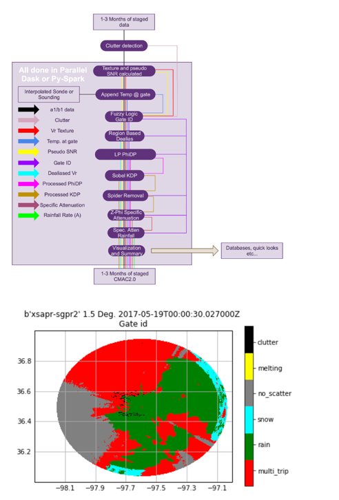
Raw data from the Atmospheric Radiation Measurement (ARM) user facility’s precipitation radars must be corrected for atmospheric phenomena and instrument characteristics (e.g., attenuation, clutter) to retrieve precipitation properties. A new value-added product (VAP)—Corrected Moments in Antenna Coordinates Version 2 (CMAC2)—is a set of algorithms and code that does such corrections, and it also retrieves precipitation quantities from the radar measurements.
Starting with the X-Band Scanning ARM Precipitation Radar (XSAPR) network at ARM’s Southern Great Plains (SGP) atmospheric observatory, CMAC2 provides higher-quality precipitation radar data and retrieved quantities for researchers. This VAP does the following:
- adds new fields, in the radar’s natural coordinates of radius, azimuth, and elevation that correct for artifacts
- provides information on how some fields are affected by attenuation—decreased radar signal strength—due to absorption of the microwave radiation by water molecules
- provides an estimate of the rainfall rate.
CMAC2 introduces the concept of a gate identification (or ID), a pre-retrieval, pre-correction classification of which type of particle (e.g., raindrop, snowflake) is dominant in scattering power back to the radar receiver. This classification technique is based on work by Jonathan Gourley and Brenda Dolan. The gate ID is then used to determine the appropriate corrections to apply to each measurement (e.g., attenuation correction in rain, Doppler velocity dealiasing in passive tracers).
CMAC2 is being run routinely on the three SGP XSAPRs when they are in operational mode. Data appear in the ARM Data Center on an approximate three-month delay from when they are collected.
Currently, data go back to August 30, 2018, and are only available for the nested constant elevation mode (also known as volumetric plan position indicator mode). However, data from an SGP scanning experiment in summer 2018, during which ARM tested several space and time sampling strategies for the XSAPRs, will be added in the coming months.
While data will be available on an operational basis, the data can be problematic in complex cases (e.g., when assumptions in the retrieval fail). If users find issues, they are encouraged to contact the translator responsible for CMAC2, Scott Collis.
CMAC2 is available as a netCDF file compliant with CF-Radial 1.4 standards.
Scientists can use the CMAC2 data now. CMAC2 is being regularly produced from the XSAPR network at the SGP, with more sites and radars to follow.
This data set can be analyzed and built on with the Python ARM Radar Toolkit (Py-ART), an open-source architecture for interacting with radar data in the Python programming language, and other community code. CMAC2 is in a modular format, which means that modules can be removed, changed, or added. The VAP team is always interested in improving processing and contributions to Py-ART to directly feed CMAC2.
To share your experience with the VAP or to ask questions, contact Robert Jackson, Zach Sherman, or Scott Collis.
More information on CMAC2 can be found on the VAP web page.
Access the data set in the ARM Data Center. (Go here to create an account to download the data.) This VAP is also included in the Py-ART open-source radar code available on GitHub.
To cite the CMAC2 data, please use doi:10.5439/1573362.
Follow Us:


Keep up with the Atmospheric Observer
Updates on ARM news, events, and opportunities delivered to your inbox
ARM User Profile
ARM welcomes users from all institutions and nations. A free ARM user account is needed to access ARM data.


