

Two New Data Products Available from the Radar Wind Profiler
Published: 19 March 2017
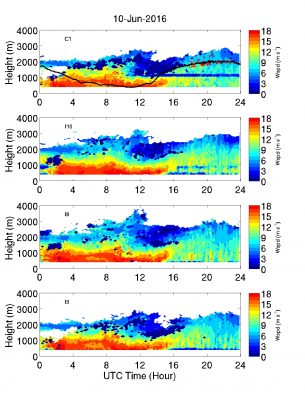
The radar wind profiler (RWP) records the full Doppler spectrum in a wind mode and a precipitation mode. The data from the wind mode are used to calculate the first three moments of the Doppler spectrum (reflectivity, mean Doppler velocity, and spectrum width) with the mean Doppler velocity further used to retrieve boundary-layer winds.
The retrieved winds are often used for forcing model simulations and evaluations. Here, the raw Doppler spectrum data collected during the wind mode was used to recalculate the moments using an improved noise estimate. Further, the profiles of boundary-layer winds were retrieved at a uniform 10-min resolution at all locations using the improved algorithm. Two RWP datastreams are produced:
- rwpwindmoments: Improved estimates of radar moments from the boundary-layer mode
- rwpwindwinds: Improved estimates of boundary-layer winds at 10-minute resolution.
RWP-Wind evaluation data are available for all of the observing facilities at the ARM Southern Great Plains (SGP) megasite and Eastern North Atlantic (ENA) observatory for the summer months of 2015 and 2016. More information on the value-added product is available in the README file, which accompanies the data files in the ARM evaluation area. Efforts are currently underway to make the algorithm operational for continuous production.
During this evaluation period, please send any comments and suggestions related to the product to Virendra Ghate. Feedback will help improve the data product prior to its full release. To access the data set, please browse the ARM Data Archive. (Go here to create an account to download the data.)
# # #
The ARM Climate Research Facility is a national scientific user facility funded through the U.S. Department of Energy’s Office of Science. The ARM Facility is operated by nine Department of Energy national laboratories.
The ARM Climate Research Facility is a DOE Office of Science user facility. The ARM Facility is operated by nine DOE national laboratories, including .
Follow Us:


Keep up with the Atmospheric Observer
Updates on ARM news, events, and opportunities delivered to your inbox
ARM User Profile
ARM welcomes users from all institutions and nations. A free ARM user account is needed to access ARM data.


