New Flagship Data Product Launched
Published: 1 November 2012
Climate Modeling Best Estimate Transitioned to ARM Best Estimate
 The ARM showcase data set CMBE, previously released as an evaluation product, transitioned to an ARM production data set and became the first two products of the new ARMBE value-added product. The new flagship ARMBE product name will represent all the ARM best estimate products. Transitioning CMBE to ARMBE required changing the metadata to meet ARM production data standards, but also brings the new release of ARM Best Estimate Cloud Radiation (ARMBECLDRAD) and ARM Best Estimate Atmospheric Measurements (ARMBEATM), as outlined below.
These first ARMBE data products consist of best estimates of many ARM measurements specifically designed for climate modelers to use in the evaluation of global climate models. They contain a best estimate of several cloud, radiation, and atmospheric quantities. Data are averaged over 1-hour time intervals and are available for the Southern Great Plains Central Facility (SGP.C1), North Slope of Alaska Central Facility (NSA.C1), and all the Tropical Western Pacific sites (TWP C1, C2, and C3).
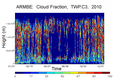
This data release extends the data sets for ARMBECLDRAD to include reprocessed cloud fraction using the improved ARSCL cloud algorithm that corrects for clear sky detected by the ceilometer/lidar cloud base estimate. The algorithm now uses ceilometer/lidar cloud base only to correct the cloud base when clouds are detected, and clear sky is determined by lidar/radar only. It also adds satellite data from VISST as well as CERES data to the NSA and TWP sites data. For the SGP site, ARMBECLDRAD now contains clear-sky downwelling shortwave from broadband shortwave radiometers. This release of ARMBEATM includes new eddy correlation QCECOR flux data. The following data are currently available:
For ARMBEATM:
- NSA.C1: North Slope Alaska, Barrow, AK, 01/01/2001 – 12/31/2011
- SGP.C1: Southern Great Plains, Lamont, OK, 01/01/1994 – 12/31/2012
- TWP.C1: Tropical Western Pacific, Manus Island, PNG, 01/01/1996 – 12/31/2011
- TWP.C2: Tropical Western Pacific, Nauru Island, 01/01/1998 – 12/31/2011
- TWP.C3: Tropical Western Pacific, Darwin, Australia, 01/01/2002 – 12/31/2011
For ARMBECLDRAD:
- NSA.C1: North Slope Alaska, Barrow, AK, 01/01/1998 – 12/31/2010
- SGP.C1: Southern Great Plains, Lamont, OK, 01/01/1996 – 12/31/2011
- TWP.C1: Tropical Western Pacific, Manus Island, PNG, 01/01/1996 – 12/31/2010
- TWP.C2: Tropical Western Pacific, Nauru Island, 01/01/1998 – 12/31/2010
- TWP.C3: Tropical Western Pacific, Darwin, Australia, 01/01/2002 – 12/31/2010
All ARMBE data also received DOI numbers and can be cited and identified by those numbers. Please provide feedback on ARMBEATM and ARMBECLDRAD to Renata McCoy and Shaocheng Xie. Feedback collected will be used to improve these data products and guide future data development.
To access these data, log in to the Data Archive. (Go here to request an account.)
The ARM Climate Research Facility is a DOE Office of Science user facility. The ARM Facility is operated by nine DOE national laboratories, including .
Keep up with the Atmospheric Observer
Updates on ARM news, events, and opportunities delivered to your inbox
ARM User Profile
ARM welcomes users from all institutions and nations. A free ARM user account is needed to access ARM data.


