

LASSO-CACTI Beta Release Available
Published: 18 May 2022
Editor’s note: William Gustafson, principal investigator for the Large-Eddy Simulation (LES) ARM Symbiotic Simulation and Observation (LASSO) activity, sent in this update.
The LASSO team is producing a new scenario focusing on high-resolution simulations of deep convection during the Cloud, Aerosol, and Complex Terrain Interactions (CACTI) field campaign. These simulations will complement the campaign’s large suite of observations. In preparation for formally releasing the LASSO-CACTI data later in 2022, a beta release now provides early versions of a portion of the data set to interested users.
The CACTI field campaign occurred along the Sierras de Córdoba mountain range in north-central Argentina. This region experiences some of the most intense mesoscale convective storms in the world. The mountain range provides a localized terrain feature to anchor storm development in a predictable location, which made for an opportune deployment of the ARM Mobile Facility from October 2018 through April 2019.
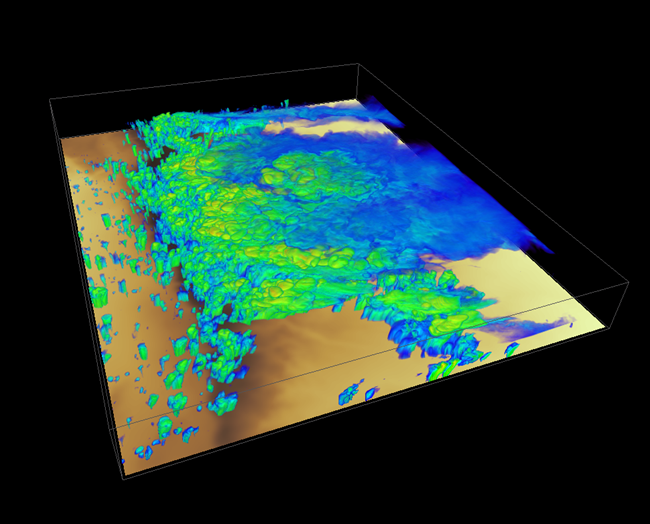
Simulations for the LASSO-CACTI scenario include mesoscale and LES runs from case dates determined through a selection process. First, the LASSO team selected 20 dates on which convective initiation occurred near the mobile facility. We generated ensemble mesoscale simulations with up to 33 ensemble members for these dates. Then, we used skill scores to evaluate each simulation against satellite brightness temperatures and radar echo-top heights. Using these scores to identify good dates for further simulation with LES, the LASSO team identified nine dates to target with LES.
The final data set will result in roughly 660 mesoscale simulations and 30 LES simulations spread over the selected dates. Barring running additional mesoscale simulations to improve results, the suite of mesoscale ensembles is complete, with the LES simulations ongoing.
The beta release will include the suite of mesoscale runs, skill scores, and a limited number of the LES. Users interested in accessing the beta release should first look over associated information in the LASSO-CACTI discussion forum and then contact lasso@arm.gov with questions and to express interest in accessing the data.
Because the data are not yet in final format, users can access the data on ARM’s Cumulus high-performance computing cluster. (Users will need an ARM allocation and account on Cumulus to access the data. Learn how to request access.) The total data set size for the raw mesoscale output is around 210 terabytes, and each LES run adds an additional 37 terabytes.
Eventually, users will be able to access LASSO-CACTI data through ARM’s Data Discovery and the LASSO Bundle Browser.
Follow Us:


Keep up with the Atmospheric Observer
Updates on ARM news, events, and opportunities delivered to your inbox
ARM User Profile
ARM welcomes users from all institutions and nations. A free ARM user account is needed to access ARM data.


