

Where There is Smoke, There is a Data Set!
Published: 11 April 2017
Editor’s note: Paquita Zuidema, a professor at the University of Miami, Rosenstiel School of Marine and Atmospheric Science, and principal investigator for the Layered Atlantic Smoke Interactions with Clouds (LASIC) campaign, sent this update.

I’m excited to share that early LASIC measurements make it clear that black carbon, the component of smoke that most strongly absorbs sunlight, is not only almost always present at the surface of Ascension Island, but at times in extremely high concentrations. During those times, the amount of smoke measured at Ascension is comparable to that measured directly downstream of wildfires in eastern Washington during ARM’s Biomass Burning Observation Project (BBOP) campaign.
In the time series of data analyzed from May 18 to November 30, smoke was detected at the first ARM Mobile Facility (AMF1) 94 percent of the time (using a 2 ng/m^3 threshold for the black carbon mass concentration). Several time periods were particularly smoky, and I have indicated the peak days on this image.
August was the month with the most smoke overall. What was truly unexpected is both 1) the peak numbers and 2) how commonly smoke was detected.
This is remarkable because the remote island is ~1,700 kilometers away from the source of the smoke. While southern Africa produces one-third of the planet’s carbon from fires, it has never been clear where the smoke is ultimately deposited. Similar trends are also evident in the absorption of red, green, and blue light, and in the number of particles that can nucleate cloud droplets.
Prior to LASIC, only one anecdotal aircraft profile, taken in the year 2000, hinted at the possibility that smoke could be present in the boundary layer.
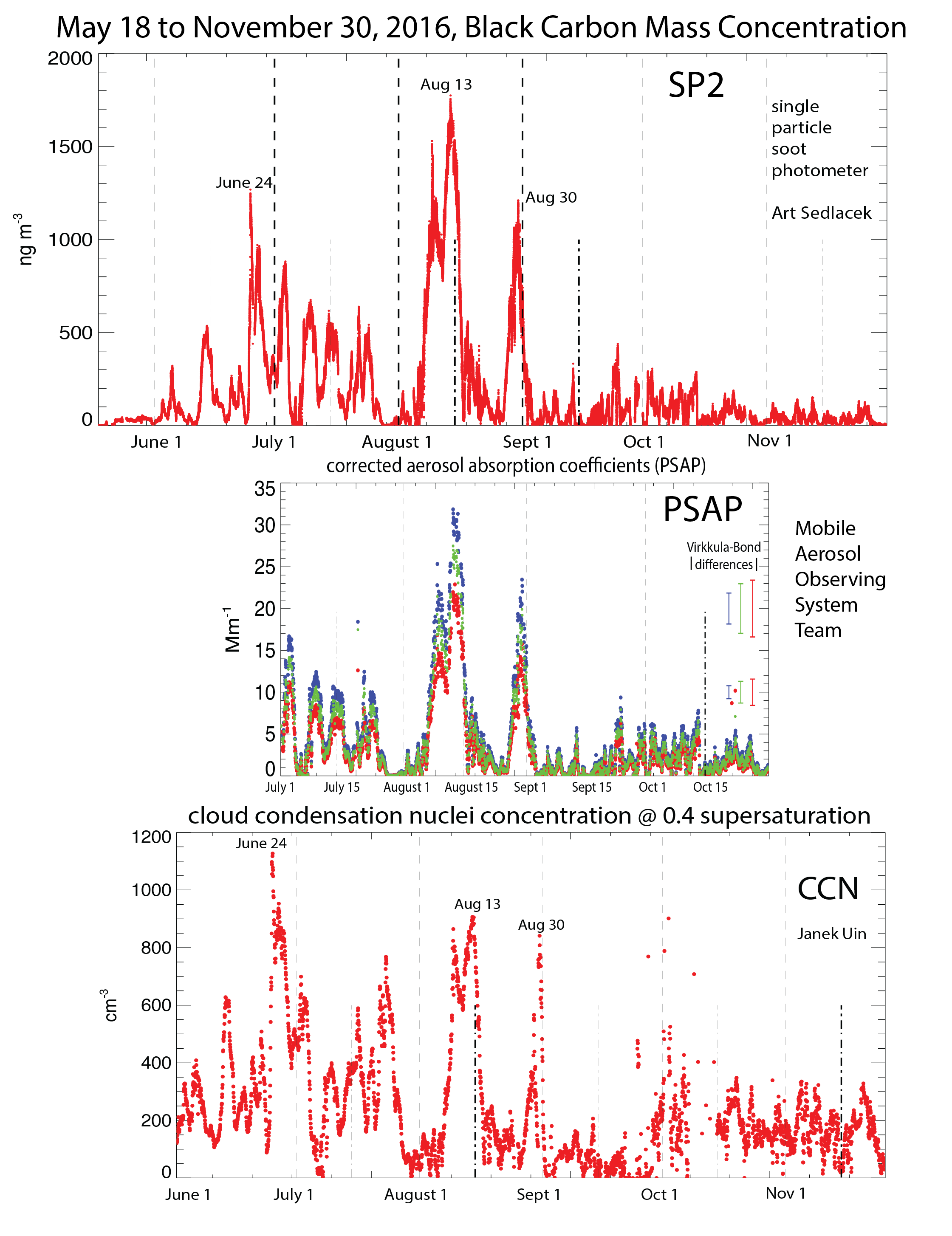
A second look at the plotted data also shows that the black carbon is associated with relatively more cloud condensation nuclei early on in the summer, suggesting the composition of the smoke may change as the season evolves.
We are also fortunate that the AMF1 will be present on the island through October 31, 2017. This means the same instruments will sample two biomass burning seasons and allow us to see if the seasonal evolution is consistent.
These LASIC measurements represent the culmination of the efforts of many dedicated scientists, the technical crew and logistics managers—all of whom must negotiate the challenges of working in such a remote, isolated site.
This is an amazing data set.
The ARM Climate Research Facility is a DOE Office of Science user facility. The ARM Facility is operated by nine DOE national laboratories, including .
Follow Us:


Keep up with the Atmospheric Observer
Updates on ARM news, events, and opportunities delivered to your inbox
ARM User Profile
ARM welcomes users from all institutions and nations. A free ARM user account is needed to access ARM data.


