Seasickness in Spirit!
Published: 16 February 2013
The images in this post are graphic and could very well be those of me on a boat. Eight years ago, as a first-year graduate student, I was participating in a week-long oceanographic research cruise just off the coast of southern California. A severe case of seasickness rendered me so nauseous and incapable of work that I decided never to set foot on a boat again—and I haven’t so far.
Hopefully, this will not be the fate for several instruments that participated in their first-ever marine operation last fall. Between October of 2012 and January of 2013, one of the two mobile facilities maintained by the U.S. Department of Energy’s Atmospheric Radiation Measurement (ARM) Climate Research Facility, went on its first extended marine mission. The goal of this campaign (MAGIC, or the Marine ARM GPCI Investigation of Clouds) was to collect a range of climate and weather-related data to understand cloud processes over the eastern Pacific Ocean.
Known as the second ARM Mobile Facility, or AMF2, this instrument suite has travelled around the world to gather data for up to a year at a time, but MAGIC was different. AMF2 was onboard a cargo ship that went about its business back and forth between Los Angeles and Honolulu while instruments continuously gathered data for three months, about eight round trips.
Doing anything onboard a moving platform is a risky proposition; ships are particularly bad, though. Several motions, like roll, pitch, heave, etc., occur continuously, leading to seasickness in some of us, of course, but instruments are not spared either. Take a look:

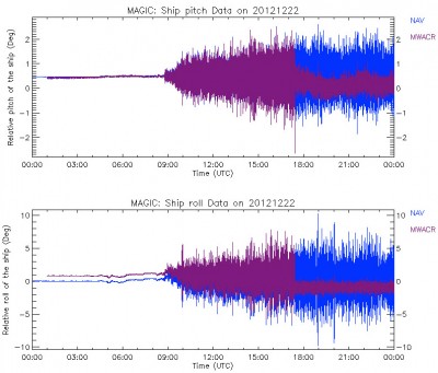
This image is a good illustration of how two kinds of regular ship motions, pitch (up and down motion of the bow of the ship) and roll (sideways lulling) affect instruments that were onboard the cargo ship. Shown in blue is an instrument called the Navigational Location and Attitude, or NAV, and shown in purple is a special kind of radar, known as the marine W-band (95 GHz) ARM cloud radar, or M-WACR.
Time starts on the left at 00.00, when the ship leaves port in Hawaii on December 22, 2012. At first it is docked, and sure enough, there is not a whole lot of motion going on with the ship. The ship then leaves port around 0830 UTC. Some motion, not a whole lot. As the ship picks up speed and reaches more open waters, the roll and pitch increase—see how the blue band becomes noisier and noisier.
Luckily, engineers had anticipated this. That is why they had onboard stabilizing platforms; when placed on those platforms, the instruments get a smoother ride. Now notice the purple instrument—the radar—and how it starts to become noisy at the same time as the blue NAV, but just before evening around 18.00 UTC (6 PM), the movement reduces significantly.
The stabilizing platform had started working.
It is as if the purple instrument was suddenly placed on a flat ship with no motion, which is what you see on the vertical axis—0 is when the ship is level and ten is when the ship is ten degrees tilted when compared to a level ship. In short, with the stabilizing board, you can achieve the effect of a “flatter” ship even while moving.
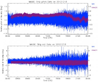
To share another image with you, this shows how the ride is on a stormy day, December 18, 2012. Notice how the roll and pitch increases gradually from about 3:00 pm. The blue NAV is not on a platform and records the full amount of motion, whereas the purple radar is on the platform and does not feel that motion as much. On such stormy days, no matter what you do to stabilize the instruments it is tough to achieve a flat ship.

Notice the purple band getting quite queasy toward nighttime. Either way, I am glad I was not on the boat! Stabilizing table or no stabilizing table, I’m glad I am sticking to my promise.

Now the blue NAV, so seasick with all the travel, comes to the rescue. The blue NAV measurements are used to correct the data from those instruments that did not find a spot on the platform.
More next time!
Aloha, Atreyee
Atreyee Bhattacharya is a science writer and a new member of the ARM Communications Team.
Special thanks to Adam Theisen, data quality analyst at the ARM Data Quality Office at the University of Oklahoma. Theisen reviews AMF2 data and was kind enough to provide both of the data plots from MAGIC.
The ARM Climate Research Facility is a DOE Office of Science user facility. The ARM Facility is operated by nine DOE national laboratories, including .
Keep up with the Atmospheric Observer
Updates on ARM news, events, and opportunities delivered to your inbox
ARM User Profile
ARM welcomes users from all institutions and nations. A free ARM user account is needed to access ARM data.


