

The (Almost) Dream Scenario
Published: 21 May 2011
Long before the MC3E scientists arrived in Ponca City and descended upon the SGP Central Facility (CF), there was a great deal of talk about the “dream scenario.” The golden case of all golden cases was described as a well defined line of convective storms with a large stratiform rain region that propagated directly over the SGP CF. While this dream system moved over the site it would be sampled by all the CF instrumentation including the new scanning radar systems, sliced and diced by the N-Pol and D3R radars, and sampled from above by the NASA ER-2 and within by the UND Citation along well defined cross sections over the CF. We need to sample all different types of convective storms and have much to learn from all shapes and sizes of clouds and storms during MC3E, but on the morning of Friday, May 20, we came as close as possible to the “dream scenario”.
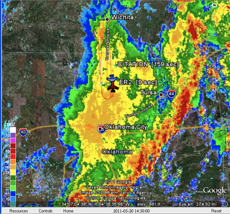
Based on the Thursday afternoon weather update, a 7:00 am CDT take-off time had been set for the ER-2 with the UND Citation also taking to the skies at 8:00 am CDT and a 4:00 am CDT final briefing for the ER-2 crew. The entire MC3E team went to sleep Thursday evening excited for the next day’s operations sampling widespread convection and precipitation. At the early morning briefing we found that the convection was already well organized with a great squall line and large stratiform rain area to the southwest of the site moving right towards us. This called for a quick change of plans by the mission scientists (Steve Rutledge, CSU; Larry Carey, UAH) as both aircraft crews were asked to prepare to take-off as soon as possible, and the mission scientists and forecasters rushed out to the CF. On the drive out to the site we were treated to an incredible lightning display from the leading edge of the convective line. Everyone arrived at the site by 4:45 am and watched in anticipation as the storms moved towards the site.
The UND Citation took off shortly after the leading convective edge passed through Ponca City (8:10 am CDT) and immediately began a series of N-S stepped legs over the CF. After being delayed by lightning and hail in Omaha, Nebraska, the ER-2 took off at 8:15 am CDT and arrived in north-central Oklahoma about an hour later joining the Citation in a series of stacked legs over the CF. Unfortunately, the N-Pol, which had been operating flawlessly since the beginning of the experiment, had some mechanical problems and could not perform the scans described in the dream scenario. To fill this gap, after some great coordination between Scott Giangrande (BNL) at the CF and Nitin Bharwadaj (PNNL), the C-band ARM scanning precipitation radar (C-SAPR) modes were changed on the fly to perform RHI scanning along the aircraft flight lines. The (almost) “dream scenario” was accomplished.
In the end, this large mesoscale convective system may be the best sampled ever, and these observations are sure to provide numerous scientific insights into the physics within these storm types. Kudos to all who made this such a successful mission.
Sumbitted by Dr. Michael Jensen, MC3E principal investigator, Brookhaven National Laboratory.
The ARM Climate Research Facility is a DOE Office of Science user facility. The ARM Facility is operated by nine DOE national laboratories, including .
Follow Us:


Keep up with the Atmospheric Observer
Updates on ARM news, events, and opportunities delivered to your inbox
ARM User Profile
ARM welcomes users from all institutions and nations. A free ARM user account is needed to access ARM data.


