

Variability of ice hydrometeor shapes with temperature
Submitter
Matrosov, Sergey — University of Colorado
de Boer, Gijs — Brookhaven National Laboratory
Area of Research
Cloud Processes
Journal Reference
Matrosov S, A Ryzhkov, M Maahn, and G Boer. 2020. "Hydrometeor shape variability in snowfall as retrieved from polarimetric radar measurements." Journal of Applied Meteorology and Climatology, 59(9), 10.1175/JAMC-D-20-0052.1.
Science
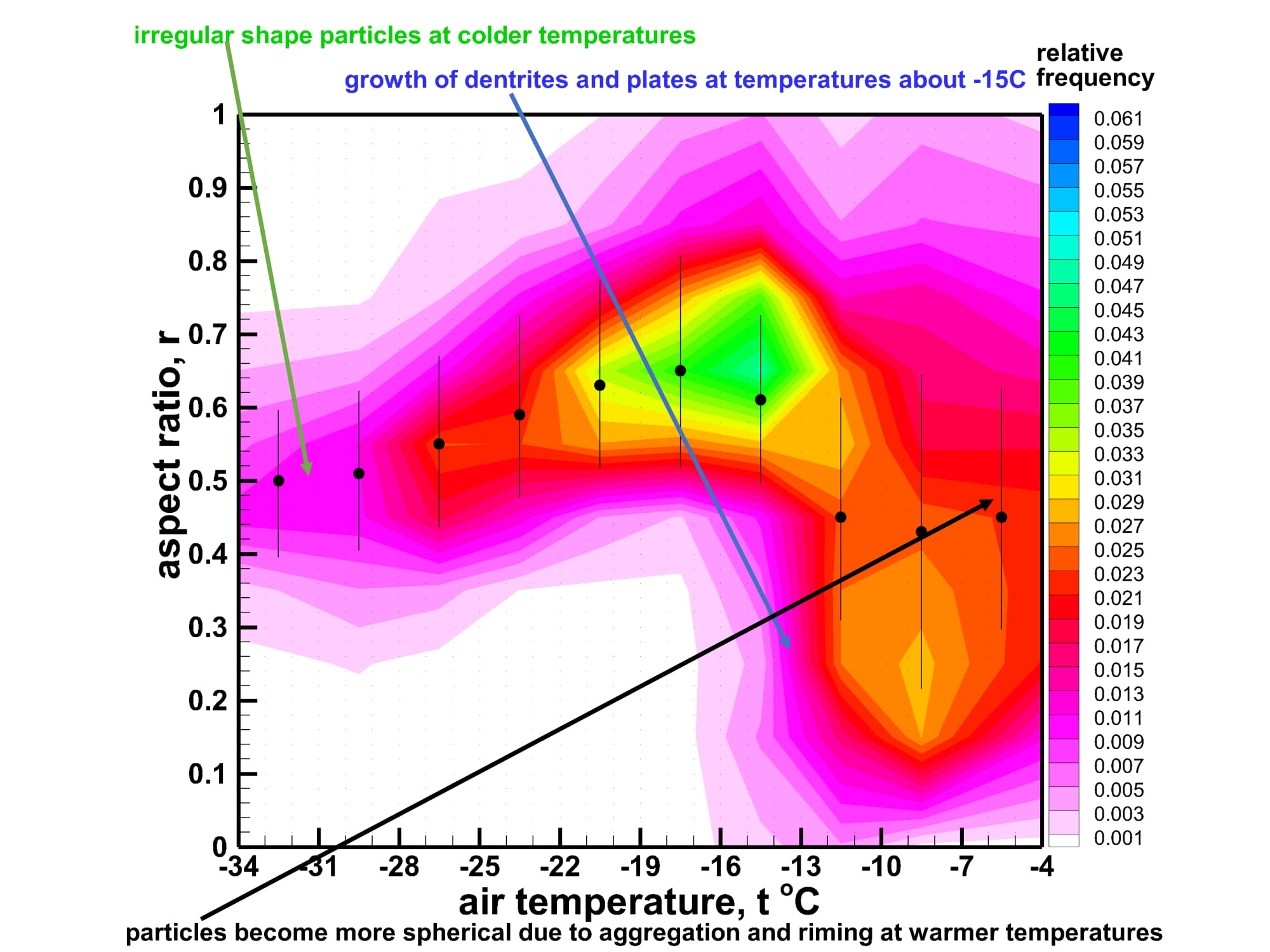
Figure 1. Frequency of occurrence scatter plot of ice hydrometeor aspect ratios versus ambient temperature for the Oliktok Point, Alaska observational event of 21 October 2016. From journal.
A polarimetric radar-based method to retrieve atmospheric particle shapes was applied to measurements of precipitating ice and mixed-phase clouds in the Arctic. Retrieval results were statistically analyzed to evaluate variability of ice hydrometeor aspect ratios (i.e., the ratios of particle minor to major dimensions) in the vertical column as a function of height and temperature.
Impact
Knowledge of mean ice particle shapes will result in more accurate retrievals of bulk cloud and precipitation properties (e.g., ice water content, parameters of particle size distributions) and quantitative precipitation estimation of snowfall. It will provide insights into microphysical processes governing cloud/precipitation evolutions. Statistics from ice particle shape retrievals can help to support development and advancement of microphysical schemes in numerical prediction tools for weather and climate.
Summary
The retrievals indicate that hydrometeors with mean aspect ratios below 0.2–0.3 are usually present in regions with air temperatures warmer than approximately −17° to −15°C, corresponding to a regime that has been shown to be favorable for growth of pristine ice crystals of planar habits. Radar reflectivities corresponding to the lowest mean aspect ratios are generally between −10 and 10 dBZ. For colder temperatures, mean aspect ratios are typically in a range between 0.3 and 0.8. There is a tendency for hydrometeor aspect ratios to increase as particles transition from altitudes in the temperature range from −17° to −15°C toward the ground. This increase is believed to result from aggregation and riming processes that cause particles to become more spherical and is associated with areas demonstrating differential reflectivity decreases with increasing reflectivity. Aspect ratio retrievals at the lowest altitudes are consistent with in situ measurements obtained using a surface-based multiangle snowflake camera. Pronounced gradients in particle aspect ratio profiles are observed at altitudes at which there is a change in the dominant hydrometeor species, as inferred by spectral measurements from a vertically pointing Doppler radar.
Follow Us:


Keep up with the Atmospheric Observer
Updates on ARM news, events, and opportunities delivered to your inbox
ARM User Profile
ARM welcomes users from all institutions and nations. A free ARM user account is needed to access ARM data.


