

ARM zenith radar provides insight into marine low clouds for shaping future spaceborne missions
Submitter
Lamer, Katia — Brookhaven National Laboratory
Battaglia, Alessandro — University of Leicester
Area of Research
Cloud Distributions/Characterizations
Journal Reference
Lamer K, P Kollias, A Battaglia, and S Preval. 2020. "Mind the gap - Part 1: Accurately locating warm marine boundary layer clouds and precipitation using spaceborne radars." Atmospheric Measurement Techniques, 13(5), 10.5194/amt-13-2363-2020.
Science
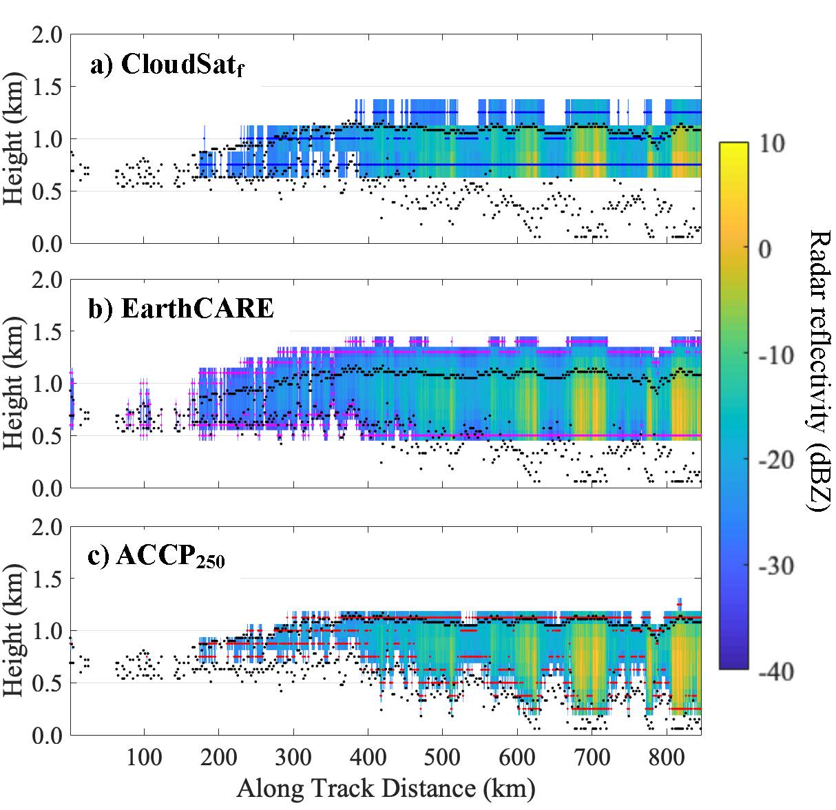
Figure 1. Based on KAZR observations of the hydrometeor layer of February 27, 2016, forward-simulated radar reflectivity (colormap) and estimated hydrometeor layer boundaries (colored dots) for a) the CloudSatf-CPR, which has 500-m range resolution and -28dBZ sensitivity (royal blue dots), b) the EarthCARE-CPR, which has the same range resolution as the CloudSat-CPR but greater sensitivity (-35 dBZ; magenta dots), and c) ACCP250-CPR, which has higher range resolution (250-m) but nearly the same sensitivity as the CloudSat-CPR (red dots). For reference, echo boundaries identified by the KAZR are overlaid on each subpanel using black dots. From journal.
Because of their ubiquitous nature and the way they interact with solar and longwave radiation, warm marine boundary-layer (WMBL) clouds play a crucial role in the global energy budget. Unfortunately, numerical models still struggle to properly represent their properties, which ultimately affects our confidence in future climate projections.
WMBL clouds cover vast areas of the globe; thus spaceborne radars observations are often preferred over ground-based and airborne to guide model developments. The current study relies on ground-based observations to quantify the limitations of current spaceborne radars when it comes to capturing the coverage and vertical structure of WMBL clouds. By comparing observations collected at the ARM Eastern North Atlantic ground-based observatory and CloudSat overpasses, we determine that CloudSat-Cloud Profiling Radar (CPR) fails to detect roughly 40% of the cloudy columns detected by the ground-based profiling radar and lidar and often provides an incomplete view of even the cloudy columns it does detect.
Using a simulator replicating the capabilities of various spaceborne radar configurations, we establish that no single radar configuration would be sufficient to characterize all aspects of WMBL clouds and precipitation because of intrinsic trade-offs. On one hand, the more sensitive EarthCARE-CPR would do better at capturing cloud cover but will generate an overestimation of cloud top height and hydrometeor fraction because of its coarse resolution (500 m). On the other hand, a fine-resolution (250-m) radar would do better at capturing the boundaries of WMBL clouds and precipitation but would suffer from cloud cover biases similar to those of the CloudSat-CPR because of its reduced sensitivity (-26 dBZ).
Impact
This study relies on ground-based observations to quantify the limitations of current spaceborne radars when it comes to capturing the coverage and vertical structure of WMBL clouds. Our finding that neither the CloudSat-CPR nor the EarthCARE-CPR will be able to accurately characterize cloud cover, cloud fraction, and the location of a large fraction of WMBL clouds further encourages the development of new spaceborne radar systems targeting WMBL clouds. The future spaceborne radar configurations explored in this study are currently under investigation at NASA in preparation for the Aerosol Cloud Convection and Precipitation (ACCP) mission.
Given the properties of WMBL clouds extracted from ground-based radars in the eastern North Atlantic -- 50% of them are thinner than 400m and 50% of the hydrometeors they contain occur below 1.2km and have reflectivities < -17dBZ -- we recommend that the next generation of space-borne radars targeting WMBL science should operate interlaced pulse modes including both a highly sensitive long-pulse and a less sensitive but clutter-limiting short-pulse mode.
Summary
Ground-based radar observations show that, in the eastern North Atlantic, 50% of warm marine boundary-layer (WMBL) hydrometeors occur below 1.2km and have reflectivities < -17dBZ, thus making their detection from space susceptible to the extent of surface clutter and radar sensitivity.
Surface clutter limits the CloudSat-Cloud Profiling Radar (CPR)’s ability to observe true cloud base in ~52% of the cloudy columns it detects and true virga base in ~80%, meaning the CloudSat-CPR often provides an incomplete view of even the clouds it does detect. Using forward simulations, we determine that a 250-m-resolution radar would most accurately capture the boundaries of WMBL clouds and precipitation; however, because of sensitivity limitations, such a radar would suffer from cloud cover biases similar to those of the CloudSat-CPR.
Overpass observations and forward simulations indicate that the CloudSat-CPR fails to detect ~36% of the cloudy columns detected by the ground-based sensors. Out of all configurations tested, the 7-dB more sensitive EarthCARE-CPR performs best (only missing 9.0% of cloudy columns), indicating that improving radar sensitivity is more important than decreasing the vertical extent of surface clutter for observing cloud cover. However, because 50% of WMBL systems are thinner than 400 m, they tend to be artificially stretched by long sensitive radar pulses; hence the EarthCARE-CPR overestimation of cloud top height and hydrometeor fraction.
Thus, we recommend that the next generation of space-borne radars targeting WMBL science should operate interlaced pulse modes including both a highly sensitive long-pulse and a less sensitive but clutte- limiting short-pulse mode.
Follow Us:


Keep up with the Atmospheric Observer
Updates on ARM news, events, and opportunities delivered to your inbox
ARM User Profile
ARM welcomes users from all institutions and nations. A free ARM user account is needed to access ARM data.


