

Seeing the Invisible: Remote Sensing of Aerosol Mass Fluxes in the Atmospheric Boundary Layer
Submitter
Meskhidze, Nicholas — North Carolina State University
Petters, Markus D
— University of California, Riverside
Area of Research
Aerosol Processes
Journal Reference
Rasheeda Satheesh A, M Petters, and N Meskhidze. 2024. "Aerosol Vertical Turbulent Mass Flux Retrievals through Novel Remote Sensing Algorithm." Journal of Geophysical Research: Atmospheres, 129(20), e2023JD040322, 10.1029/2023JD040322.
Science
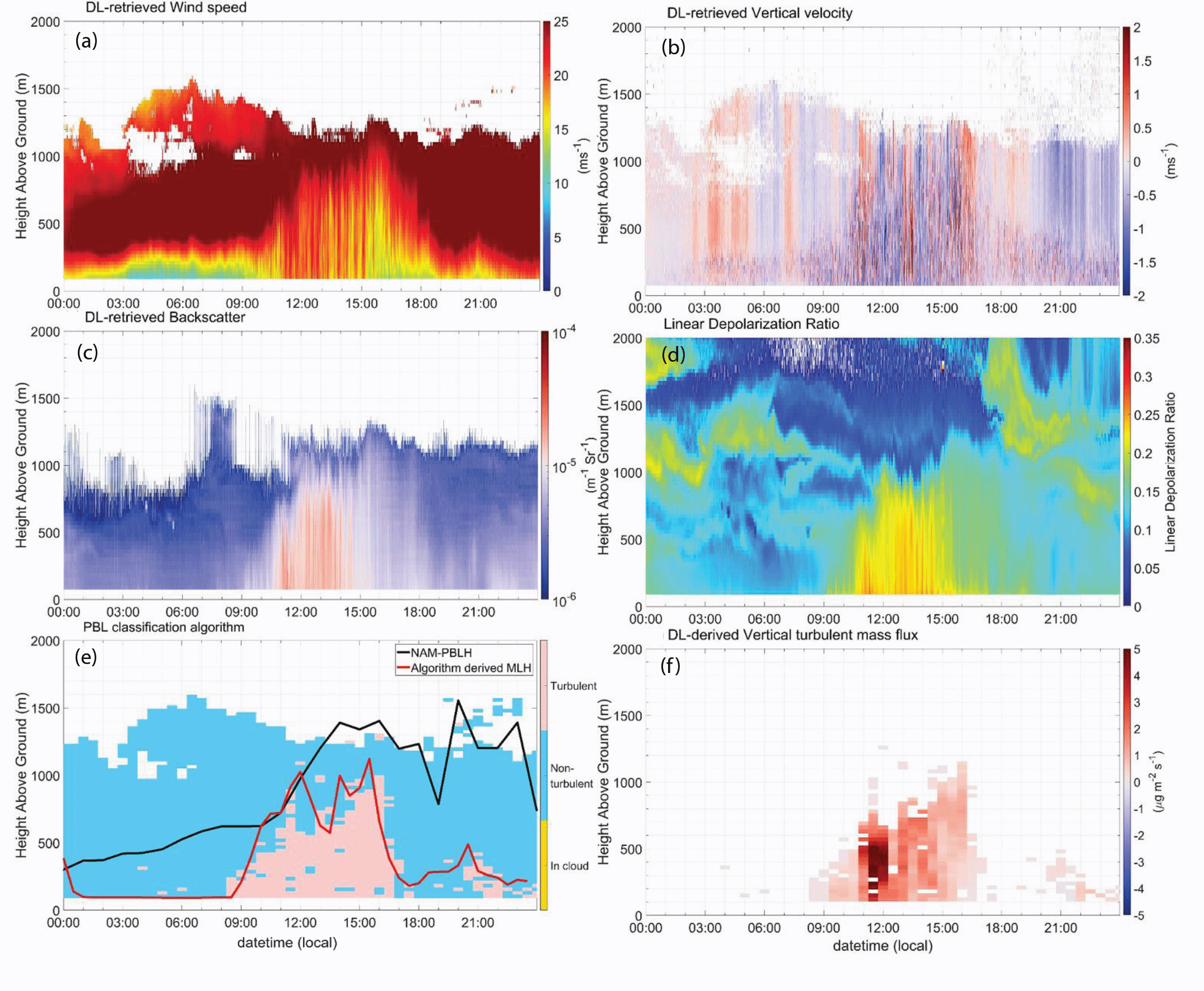
Height‐resolved time series of Doppler lidar (DL)‐retrieved (a) wind speed, (b) vertical velocity, and (c) backscatter; (d) High Spectral Resolution Lidar (HSRL)‐retrieved linear depolarization ratio; (e) boundary layer classification with the red squares showing the algorithm‐derived mixed layer (ML) height and the black line showing the North American Mesoscale (NAM) model‐predicted hourly Planetary Boundary Layer (PBL) height and (f) derived vertical turbulent mass flux for 18 November 2020.
Impact
Traditional aerosol flux measurements rely on tower-mounted instruments with limited spatial coverage and are predominantly conducted in easily accessible locations. Our lidar-based approach enables continuous, height-resolved measurements of particle mass transport with minimal human intervention, allowing for comprehensive monitoring in remote or challenging environments where conventional methods are impractical.Summary
Understanding aerosol transport in the atmosphere is crucial for both air quality and earth system science. This research, conducted at the Department of Energy Atmospheric Radiation Measurement Southern Great Plains (SGP) site in Oklahoma, developed a technique that identifies convective turbulent regions and derives vertical profiles of aerosol mass fluxes throughout the planetary boundary layer. The algorithm produces vertically resolved "curtains" of aerosol mass fluxes by combining measurements from Doppler lidars and high-spectral resolution lidar. Our analysis revealed that at the SGP site, aerosol fluxes at 135m above ground were primarily positive (upward) at approximately 1 μg m⁻² s⁻¹, indicating that dust particles from the surface were likely the main source of particles in this environment. Additionally, our analysis demonstrated that accurate characterization of boundary layer structure and cloud identification is essential for properly interpreting flux data. This method will lead to a more realistic representation of aerosol mass budgets and bidirectional mixing rates in models.Follow Us:


Keep up with the Atmospheric Observer
Updates on ARM news, events, and opportunities delivered to your inbox
ARM User Profile
ARM welcomes users from all institutions and nations. A free ARM user account is needed to access ARM data.


