

Using SAIL data to examine cold-season precipitation in complex terrain
Submitter
Feldman, Daniel — Lawrence Berkeley National Laboratory
Heflin, Stella — University of Washington
Area of Research
Atmospheric Thermodynamics and Vertical Structures
Journal Reference
Heflin S, M Abel, S Biswas, A Morales, R Cifelli, J Sedlar, D Feldman, V Chandrasekar, and P Kennedy. 2024. "X-band Radar and Surface-based Observations of Cold Season Precipitation in Western Colorado’s Complex Terrain." Journal of Hydrometeorology, 10.1175/JHM-D-23-0147.1.
Science
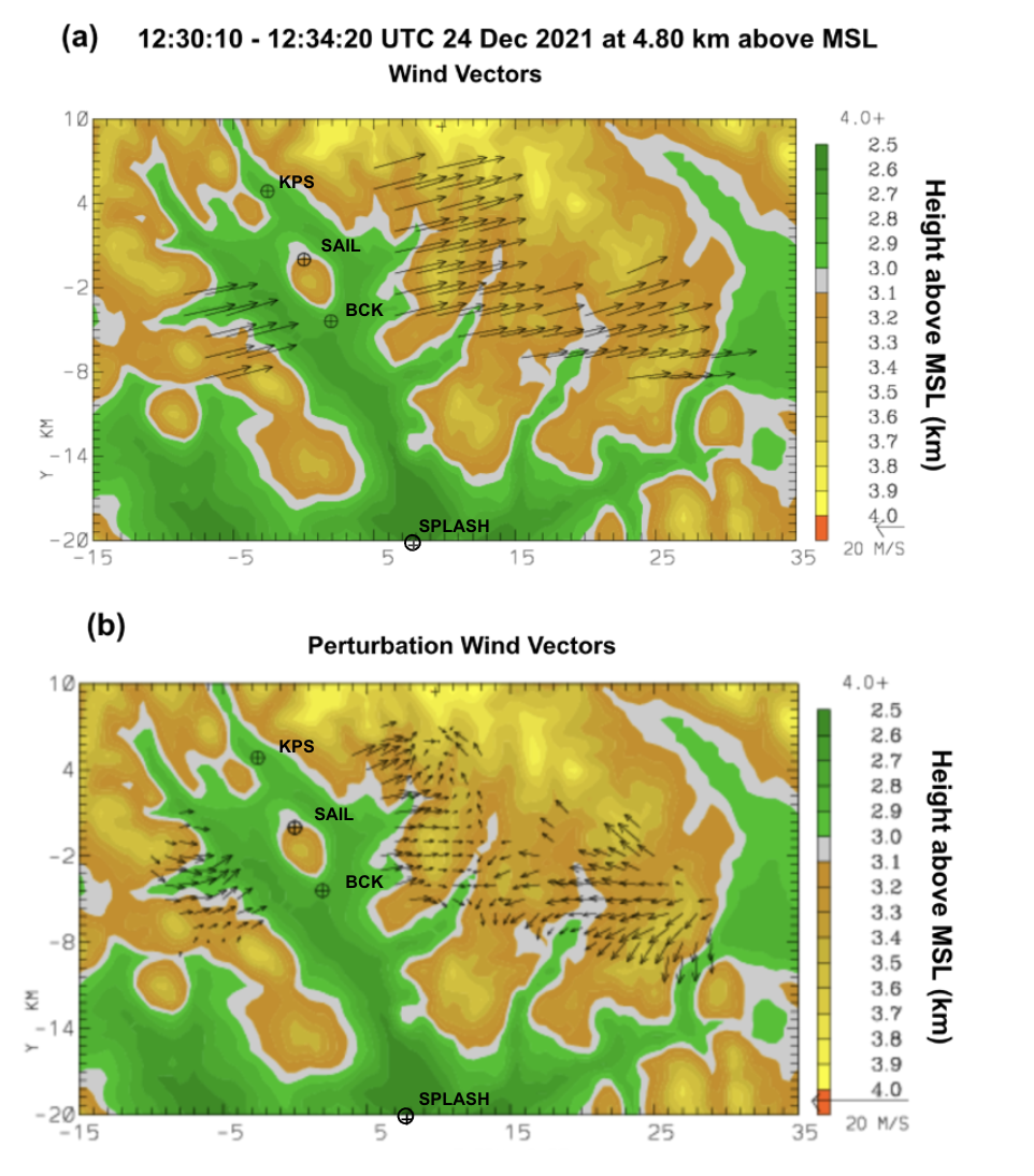
(a) Average wind speeds from SPLASH and SAIL radar data starting at 12:30:10 UTC using dual-Doppler analysis. (b) Perturbation winds during the same time step after subtracting the mean u- and v- wind components. Color shading representing topography (km). Image from journal.
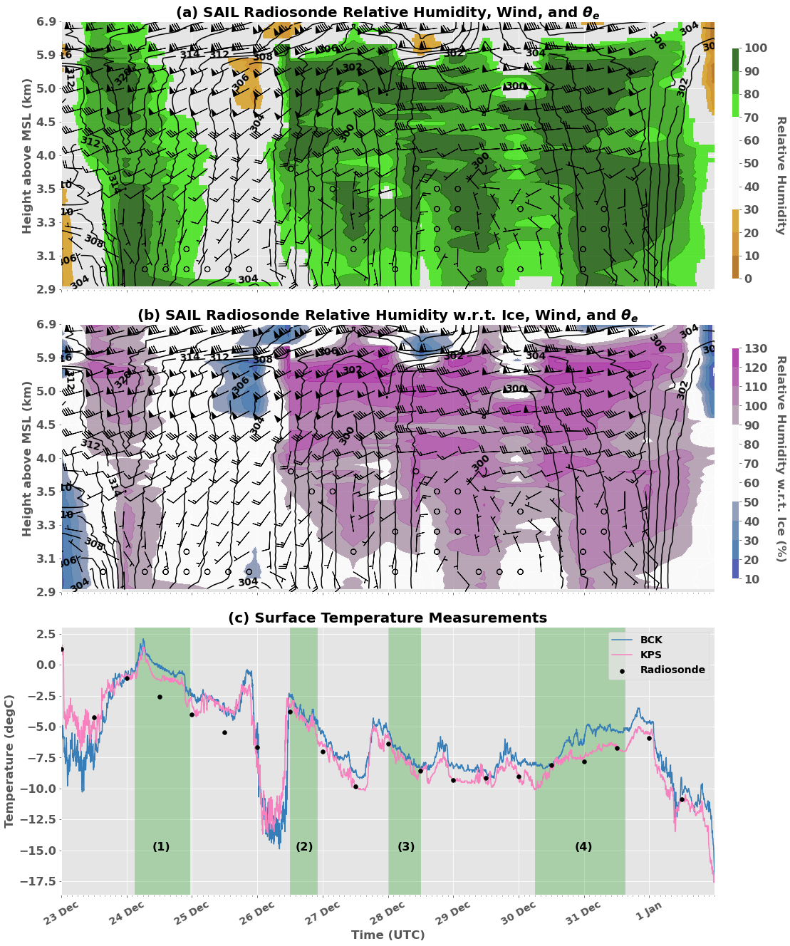
(a) Interpolated data from SAIL radiosonde showing relative humidity (color bar), equivalent potential temperature (K, black contours), and wind barbs, (b) same as (a) using relative humidity w.r.t. ice, and (c) over same frame depicts surface air temperature at two field sites (Brush Creek - BCK and Kettle Ponds - KPS) and radiosonde surface air temperature (black dots). Analysis periods denoted by the green shading and represent distinct periods of precipitation. Image from journal.
This case study focused on a series of successive winter storms in the Rocky Mountain range of the Upper Colorado River Basin, where a deeper understanding of precipitation is important not just to advancing atmospheric science in complex terrain, but also to many end-users, including those that focus on avalanche forecasting and water resource management. Unfortunately, traditional weather observation networks struggle to observe precipitation in these regions. This study used weather data collected from the SAIL and SPLASH field campaigns to help demonstrate how variable winter precipitation can be in space and time in this region, to examine extra information derived from coordinated radar scans, and to show how patterns observed in weather radar scans have clear relationships with snowfall patterns on the surface in mountainous regions.
Impact
Observations from the U.S. Department of Energy Atmospheric Radiation Measurement (ARM) user facility's Surface Atmosphere Integrated Laboratory (SAIL) field campaign were combined with those from the National Oceanic and Atmospheric Administration (NOAA) Study of Precipitation, the Lower Atmosphere, and Surface for Hydrometeorology (SPLASH) field campaign to provide data over the East River Watershed in the Rocky Mountains, a region largely missed by traditional weather observations due to terrain blockage of ground-based radar, large elevational and terrain-driven gradients in precipitation, and challenges with in situ instrumentation. These campaigns, however, achieved a high density of data that can be used to simultaneously understand how snow crystal formation and mountain-driven wind patterns affect snow near the surface. The coordinated radar scans helped provide insights into local environmental conditions: when combined with radiosonde and surface data, we were able to show how and why precipitation formed and could not have done so otherwise. The results imply that effectively predicting snowpack in the Rockies requires properly representing local wind patterns and crystal growth processes in models.
Summary
The variability of cold-season precipitation over time and space is an important feature of hydrologic processes in intermountain regions with complex mountainous terrain. This variability is examined over a consecutive series of winter storms through data sets related to wind patterns, synoptic forcings, microphysical characteristics of precipitation, and surface meteorology. Analysis shows that differences in precipitation across the area over time are mainly accounted for by synoptic forcings, such as frontal passages, while differences within the area are accounted for by the impact of variations in local wind patterns on precipitation microphysics. Patterns of surface precipitation intensity are compared and found to be correlated with observed X-band radar signatures; a relationship between a strong dendritic growth stage and intense low-density surface precipitation is reinforced by this study. This relationship demonstrates the importance of particle growth mechanisms on surface snowfall patterns in high-altitude complex terrain, underscoring the importance of realistic microphysical parameterizations for achieving skill in precipitation estimation.
Follow Us:


Keep up with the Atmospheric Observer
Updates on ARM news, events, and opportunities delivered to your inbox
ARM User Profile
ARM welcomes users from all institutions and nations. A free ARM user account is needed to access ARM data.


