

How well does the global storm-resolving E3SM simulate clouds and precipitation over the Amazon?
Submitter
Zhang, Yunyan — Lawrence Livermore National Laboratory
Tian, Jingjing — Pacific Northwest National Laboratory
Area of Research
General Circulation and Single Column Models/Parameterizations
Journal Reference
Tian J, Y Zhang, S Klein, C Terai, P Caldwell, H Beydoun, P Bogenschutz, H Ma, and A Donahue. 2024. "How Well Does the DOE Global Storm Resolving Model Simulate Clouds and Precipitation over the Amazon?" Geophysical Research Letters, 51(14), e2023GL108113, 10.1029/2023GL108113.
Science
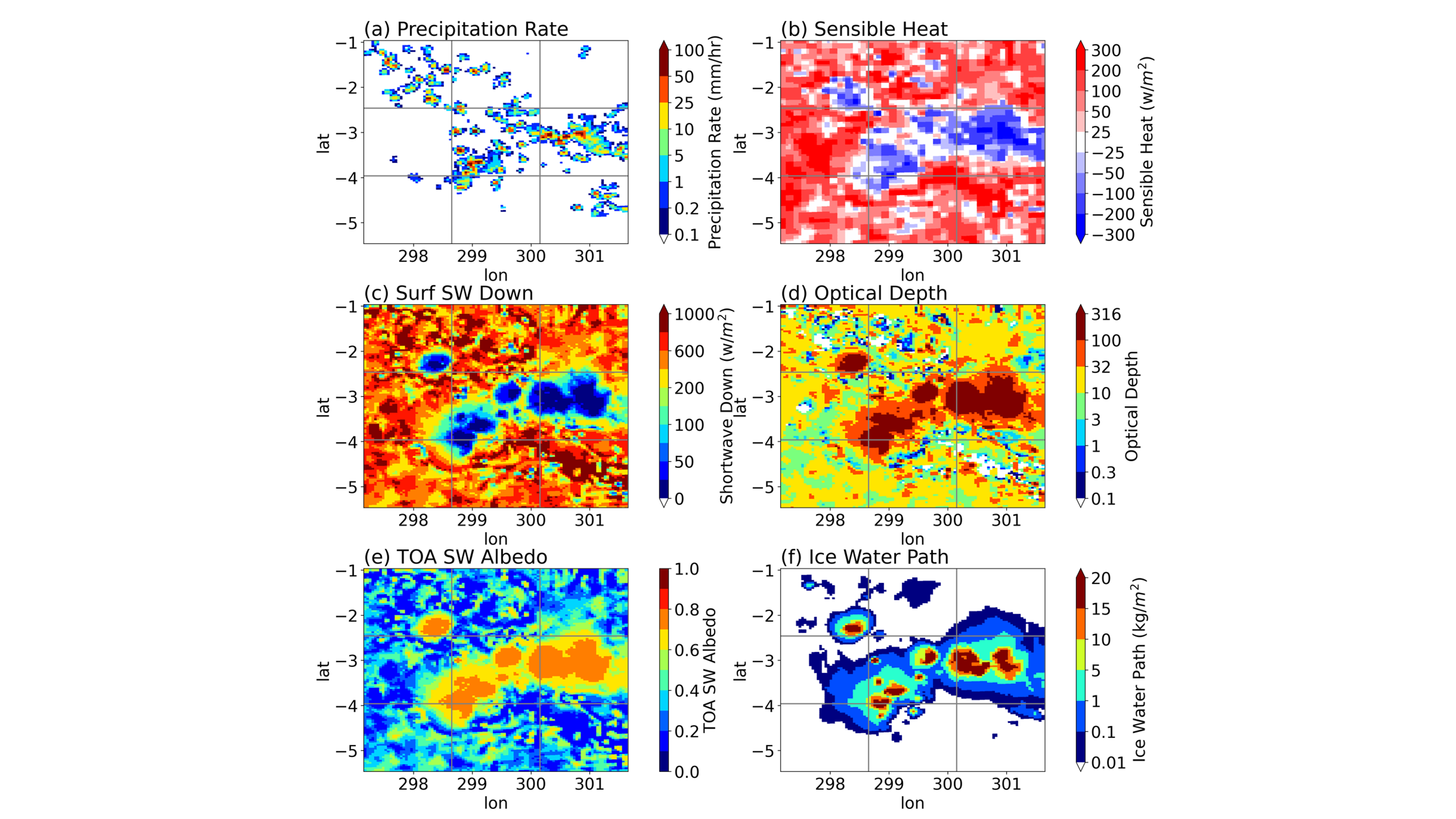
Figure 2. Spatial plots of (a) precipitation rain rate, (b) sensible heat, (c) shortwave downwelling at surface, (d) cloud optical depth, (e) TOA shortwave albedo, and (d) ice water path from SCREAMv0 model at 14:00 local time (18:00 UTC) on Jan 21, 2020. Image from journal.
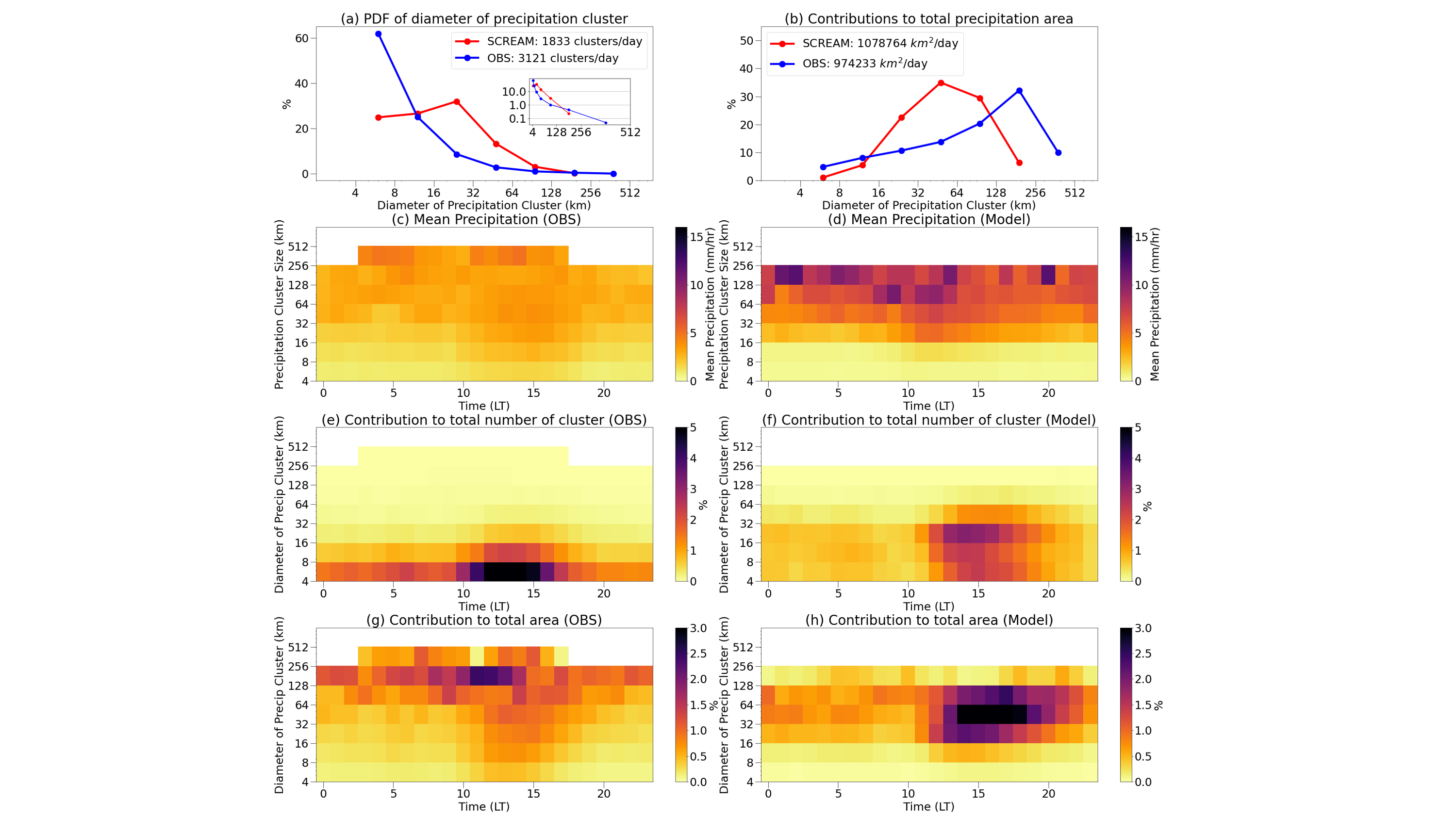
Figure 1. Comparison of precipitation cluster sizes in the 400-km analysis domain surrounding the ARM GoAmazon site. (a) Probability density function (PDF) of the diameter of precipitation clusters including an inset presenting the data on a logarithmic y-axis, emphasizing a higher contribution to the total area from 128-256-km clusters compared to the model, and (b) fractional contributions to the total precipitation area for SCREAM (red, model) and S-band scanning precipitation radar (blue, observation). Mean precipitation rate as a function of cluster size from (c) the S-band scanning radar and (d) SCREAMv0. The fractional contribution of the number of precipitation clusters in each time-size bin—normalized across all sizes for the entire diurnal cycle—is shown for (e) S-band scanning radar and (f) SCREAMv0. (g) and (h) follow a similar approach but show the fractional contribution of the cluster area in each bin to the total rain area over the day. Image from journal.
Emerging global storm-resolving models (GSRMs) at kilometer resolution, such as the U.S. Department of Energy Simple Cloud-Resolving E3SM Atmospheric Model (SCREAMv0), greatly improve the simulations of precipitation and clouds. However, they still suffer from the so-called “popcorn convection” issue, in which previous studies showed the modeled sizes of precipitating systems to be much smaller than the observed ones in satellite data, especially over tropical oceans.
Scientists from Lawrence Livermore National Laboratory confirmed this issue in SCREAMv0 using both ARM and satellite observations over the tropical forest region of Amazonia and explored the potential causes of such model biases, showing that the misrepresentation of shallow-to-deep convection transition and the land-atmosphere coupling could be the contributing factors.
Impact
This study advances our understanding of SCREAMv0's performance by pinpointing specific misrepresentations of physical processes, such as land-atmosphere interaction, and provides critical guidance on future, well-designed model sensitivity experiments for tracing error sources and reducing model biases.
Furthermore, by leveraging high-resolution ARM observations, such as scanning radar data, and aligning them with global kilometer-scale model outputs, this research establishes a diagnostic framework essential for evaluating SCREAMv0 and adaptable for other GSRMs.
Summary
This study evaluates the performance of SCREAMv0 using the high-resolution observations by cloud radar and scanning precipitation radar during the GoAmazon field campaign. SCREAMv0 reasonably captures the diurnal timing of boundary-layer clouds, such as onset and dissipation, but underestimates their fraction. SCREAMv0 lacks mid-level congestus clouds, which might be related to a too rapid transition from shallow to deep convection.
SCREAMv0 accurately replicates the diurnal cycle of area-mean precipitation intensity, but shows biases in the precipitation cluster size distribution by producing too many small clusters (<128 km) and not enough larger ones, indicating inhibited upscale growth from isolated convection to organized systems. One contributing factor could be the misrepresentation of land-atmosphere coupling in the model. Specifically, in the mid-afternoon, precipitation clusters are associated with large areas of small downward shortwave radiation. This shut-off of incoming radiation causes a significant downward transport of sensible heat from the boundary layer to the land surface, which may hinder the continuous growth and aggregation of convection and lead to more frequent occurrences of small precipitation clusters than observed.
Follow Us:


Keep up with the Atmospheric Observer
Updates on ARM news, events, and opportunities delivered to your inbox
ARM User Profile
ARM welcomes users from all institutions and nations. A free ARM user account is needed to access ARM data.


