

The vertical cloud structure of three landfalling polar lows as observed during the COMBLE campaign
Submitter
Geerts, Bart — Department of Atmospheric Science, University of Wyoming
Area of Research
Atmospheric Thermodynamics and Vertical Structures
Journal Reference
Lackner C, B Geerts, Y Wang, T Juliano, L Xue, B Kosović, and D Turner. 2023. "Insights into the relation between vertical cloud structure and dynamics of three polar lows: Observations from COMBLE." Quarterly Journal of the Royal Meteorological Society, 149(756), 10.1002/qj.4543.
Science
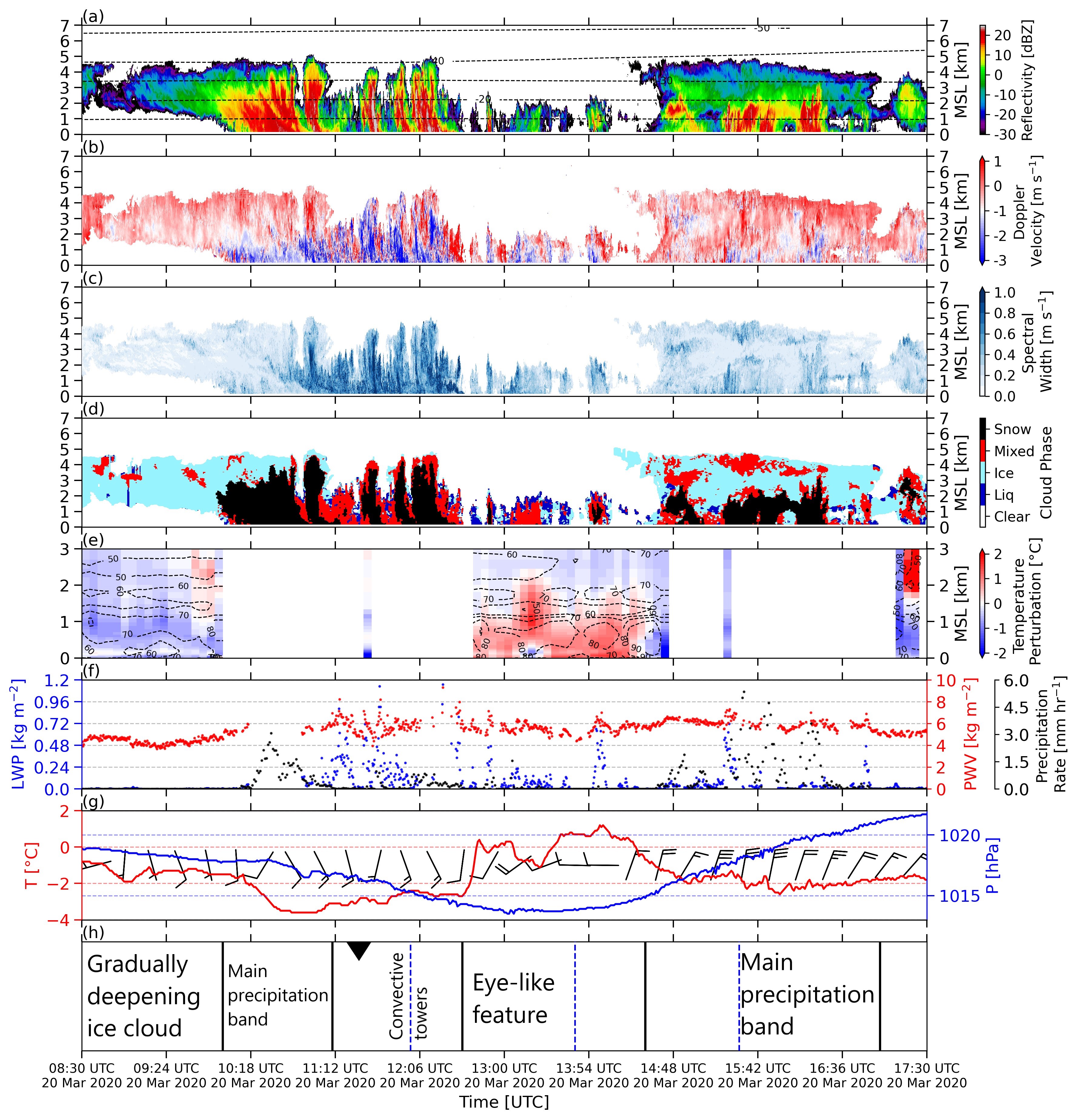
Figure 1. 9-hour vertical transects from KAZR with surface observations for Polar Low 3. (a) KAZR reflectivity factor (color fill) and INTERPOLATEDSONDE air temperature (dashed lines in ◦C; 10 ◦C interval), (b) KAZR Doppler velocity, (c) KAZR spectral width, (d) retrieved cloud phase (Liq = liquid), (e) AERI-retrieved air temperature perturbation (color fill) and relative humidity (dashed lines in %; 10 % interval), (f) MWRRET liquid water path (blue) and precipitable water vapor (red), and PWD liquid equivalent precipitation rate (black), and (g) 2-m temperature (red), sea level pressure (blue), and 10-m wind (full wind barb equals 10 knots,
plotted every 20 minutes). Panel (h) summarizes the different cloud phases. From journal.
The vertical structure of three polar lows is described using profiling
radar, lidar, and passive remote sensors deployed at a coastal
site in northern Norway. These polar lows were observed by chance as they made landfall over the first ARM Mobile Facility while it was deployed in the Cold-Air Outbreaks in the Marine Boundary Layer Experiment (COMBLE) during 2019-2020.
Impact
This is the first detailed description of the vertical cloud structure of polar lows.
Summary
The polar lows differ in synoptic origin and shear structure, but all three lows have stratiform precipitation bands, marked by little cloud liquid
water, and rather high surface precipitation rate. The vertical drafts and turbulence in these stratiform clouds are generally weak. All three lows also have convective clouds, which have stronger vertical drafts, stronger turbulence, and pockets of high liquid water content.
Follow Us:


Keep up with the Atmospheric Observer
Updates on ARM news, events, and opportunities delivered to your inbox
ARM User Profile
ARM welcomes users from all institutions and nations. A free ARM user account is needed to access ARM data.


