

High-pressure systems favor sea-breeze convection over southeastern Texas
Submitter
Wang, Die — Brookhaven National Laboratory
Area of Research
Cloud Distributions/Characterizations
Journal Reference
Wang D, M Jensen, D Taylor, G Kowalski, M Hogan, B Wittemann, A Rakotoarivony, S Giangrande, and J Park. 2022. "Linking synoptic patterns to cloud properties and local circulations over southeastern Texas." Journal of Geophysical Research: Atmospheres, 127(5), e2021JD035920, 10.1029/2021JD035920.
Science
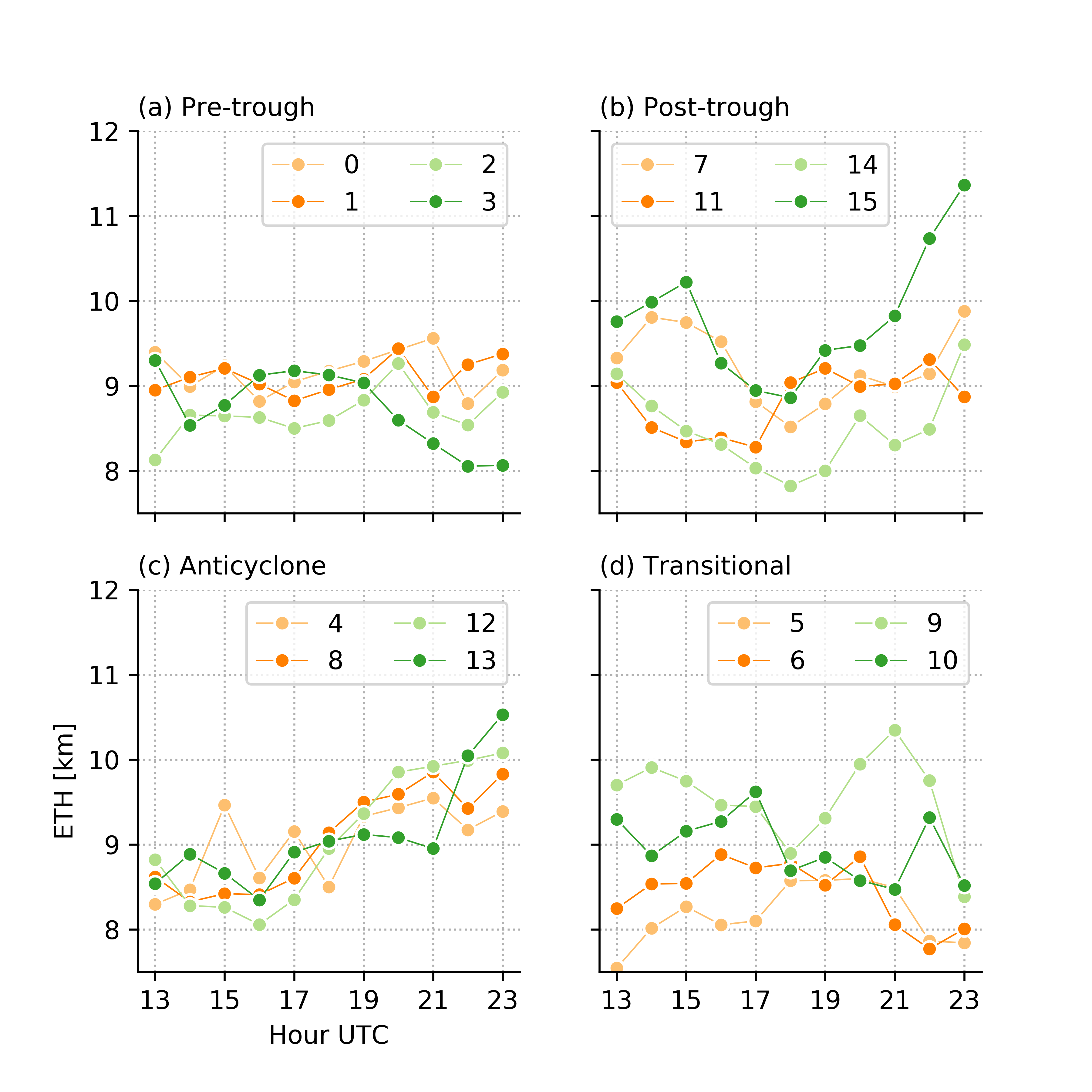
Figure 2. Diurnal cycle of mean radar echo top height (ETH) for convective cells (> 40 dBZ) from NEXRAD data within the Houston region (28.7-30.7°N, 94-96°W) for four different synoptic circulation regimes. The legends indicate the number of the 16 (0-15) SOM nodes. The anticyclonic regime tends to show a sharp increase starting from 1600 UTC, which suggests influences of diurnal heating and sea-breeze. From journal.
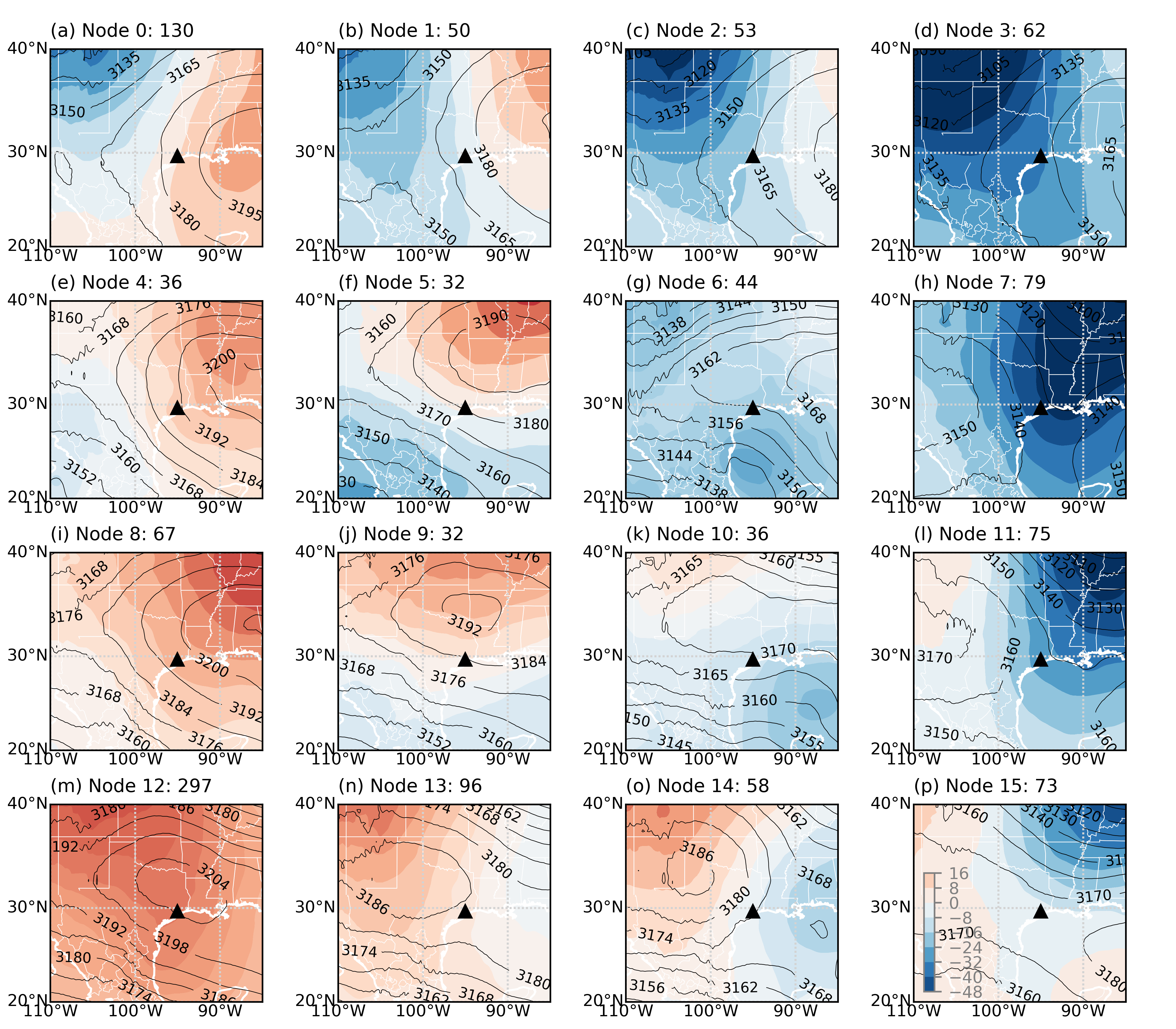
Figure 1. Composite of geopotential heights [m] (contours) and anomalies (colors) at 700 hPa for each SOM node. The number of days within each node is specified in the title of each subplot. From journal.
During the summer months, the southeastern Texas summer weather is also largely driven by sea- and bay-breeze circulations from the nearby Gulf of Mexico and Galveston Bay. These circulations, in conjunction with those from larger-scale weather systems, affect the flow of moisture and aerosol particles into the Houston region and impact the development of thunderstorms and their associated rainfall. Understanding how these flows effect clouds and storms is important to improving models used for weather forecasts and climate predictions.
Impact
This study uses artificial intelligence techniques to reveal the relationships between weather system circulations and cloud physics in southeastern Texas. Our findings include key insights into the variability of these circulations in the region providing important constraints for the study of aerosol and cloud life cycle, aerosol-cloud interactions, and air quality during the U.S. Department of Energy Atmospheric Radiation Measurement (ARM) user facility's TRacking Aerosol Convection interactions ExpeRiment (TRACER) field campaign.
Summary
The classification of the synoptic regimes during the summer months (June-September) in the southeastern Texas region is accomplished using Self-Organizing Map (SOM), an unsupervised machine learning approach. We applied the SOM to 10 years of 700-hPa geopotential height anomalies from reanalysis data to distinguish three dominant synoptic regimes, with a continuum of transitional states between them. The primary regimes include: (1) a pre-trough regime associated with a synoptic trough to the northwest of the region, (2) a post-trough regime with upper-level northerly flow, and (3) an anticyclonic regime within the westward extent of the Bermuda High. We project data from the Geostationary Operational Environmental Satellite and the Next-Generation Weather Radar system onto each SOM node to investigate the characteristics of cloud and precipitation properties (e.g., fraction, intensity) in different regimes. When southeastern Texas is positioned to the southwest quadrant of a maritime high-pressure system, increased cloud frequency is observed over the region during the afternoon hours due to significant moisture advection. A confluence of synoptic southerly flow and sea-breeze circulation commonly occurs in this regime. When a high-pressure system is over southeastern Texas, the area is dominated by large-scale subsidence with weak pressure gradients and moderate precipitable water vapor. This weak synoptic forcing is favorable for the formation of a sea-breeze circulation. This is confirmed by an enhanced onshore flow and a decreased temperature at the surface in the early afternoon, as well as a sharp increase in radar echo top height.
Follow Us:


Keep up with the Atmospheric Observer
Updates on ARM news, events, and opportunities delivered to your inbox
ARM User Profile
ARM welcomes users from all institutions and nations. A free ARM user account is needed to access ARM data.


