

A novel method to determine the coupling between clouds and the surface over land
Submitter
Li, Zhanqing — University of Maryland
Area of Research
Cloud Distributions/Characterizations
Journal Reference
Su T, Y Zheng, and Z Li. 2022. "Methodology to determine the coupling of continental clouds with surface and boundary layer height under cloudy conditions from lidar and meteorological data." Atmospheric Chemistry and Physics, 22(2), 10.5194/acp-22-1453-2022.
Science
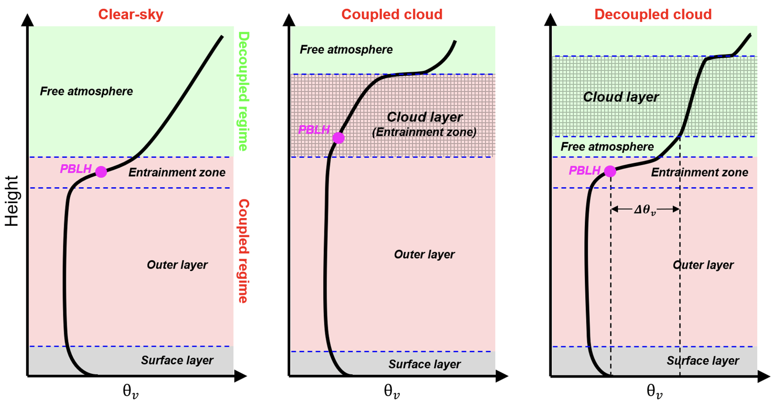
Figure 1. This figure presents idealized vertical profiles of virtual potential temperature (θν) over land when the sky is clear and for coupled and decoupled cloud scenarios. Elements (e.g., turbulence, heat fluxes, clouds) in the coupled regime and not in the decoupled regime are directly affected by PBL processes. For the coupled case, the cloud base is below the capping inversion of the entrainment zone. For the decoupled case, the cloud base is above this capping inversion. Based on the positions of the PBL and the cloud layer, we can identify the coupled regime. From journal.
The state of coupling between boundary-layer clouds and the surface is key to cloud development. This coupling has been examined over oceans but much less over land. U.S. Department of Energy (DOE) Atmospheric System Research (ASR)-sponsored researchers have developed a novel method to determine cloud coupling states from lidar observations made over land. This method is built upon advances in our understanding of fundamental boundary-layer processes and clouds, thanks to the rich observational data from DOE's Atmospheric Radiation Measurement (ARM) user facility.
Impact
As a widely accepted concept, the cloud-surface coupling of marine stratocumulus clouds over oceans has been extensively investigated. Despite its important effects on cloud development, cloud-surface coupling over land has not been understood as well, partly due to the more complex atmospheric thermodynamic structures. A bottleneck problem lies in the lack of robust methods to identify coupled clouds over land. To address this issue, this study uses lidar and meteorological data to determine cloud-surface coupling over land. As the first remote-sensing method capable of obtaining a climatology of the coupling states over ARM sites, a deeper understanding of the development of continental boundary-layer clouds and their interactions with aerosols and the surface can be gained.
Summary
Expanding on the idea for determining cloud coupling over oceans, an attempt was made to generalize the concept of coupling and decoupling of low clouds over land based on potential temperature profiles. Using ample measurements from the lidar and a suite of surface meteorological instruments installed at ARM's Southern Great Plains observatory, the planetary boundary-layer height (PBLH) and coupled states under cloudy conditions during the daytime were simultaneously retrieved. The new lidar-based method relies on the PBLH, the lifted condensation level, and the cloud base height to diagnose the cloud coupling. The coupled states derived from this method are highly consistent with those derived from radiosondes. Since coupled and decoupled clouds have distinct features, the new method offers an advanced tool to investigate them separately in climate systems.
Follow Us:


Keep up with the Atmospheric Observer
Updates on ARM news, events, and opportunities delivered to your inbox
ARM User Profile
ARM welcomes users from all institutions and nations. A free ARM user account is needed to access ARM data.


