

Three-dimensional longwave radiation in high-altitude complex terrain
Submitter
Feldman, Daniel — Lawrence Berkeley National Laboratory
Area of Research
Radiation Processes
Journal Reference
Feldman D, M Worden, N Falco, P Dennedy‐Frank, J Chen, B Dafflon, and H Wainwright. 2022. "Three‐dimensional Surface Downwelling Longwave Radiation Clear‐Sky Effects in the Upper Colorado River Basin." Geophysical Research Letters, 49(4), e2021GL094605, 10.1029/2021GL094605. ACCEPTED.
Science
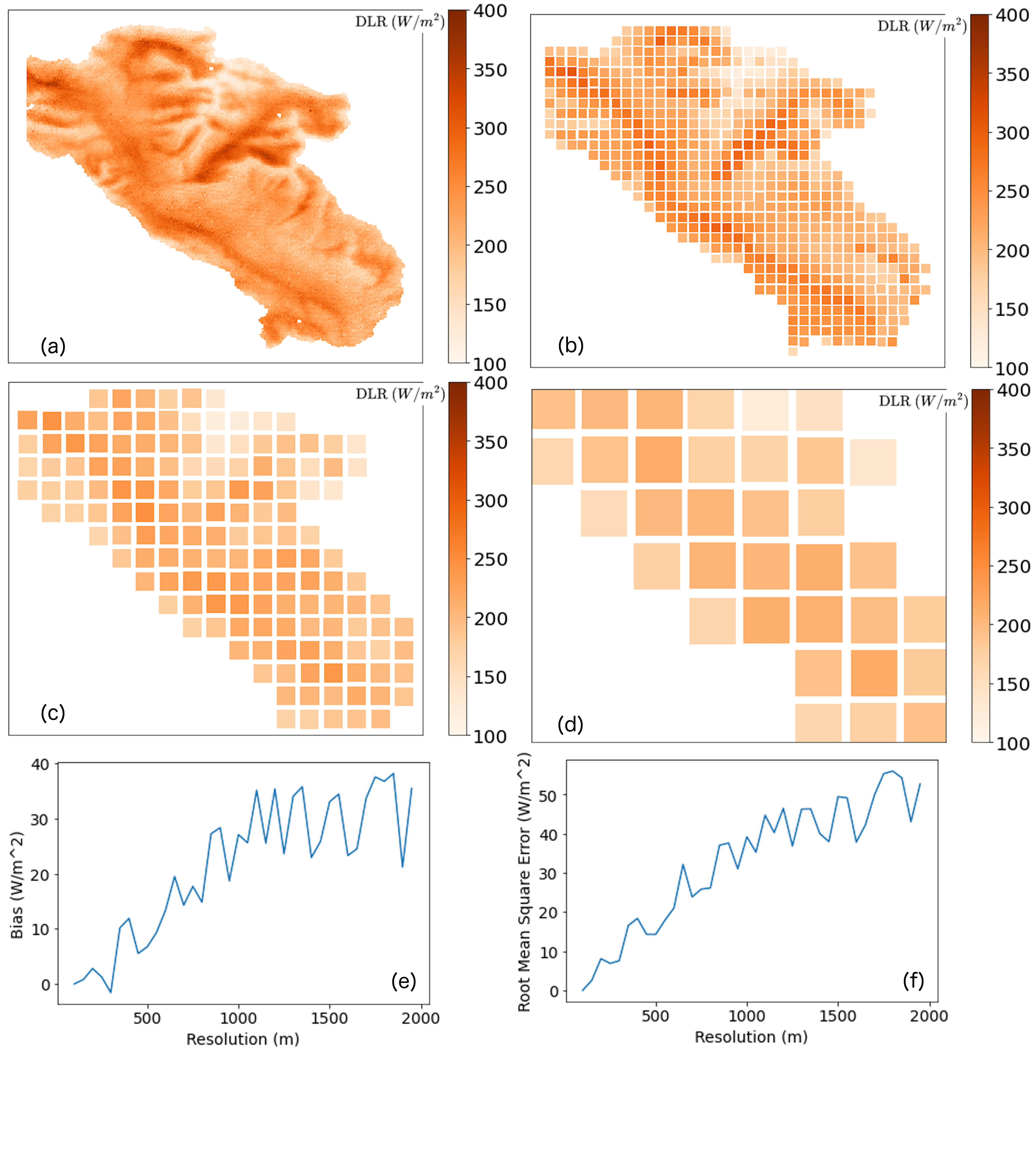
Figure 1. (a) Diurnally averaged downwelling longwave radiation (W/m2) calculated over East River Watershed (ERW) at 70-m resolution from June, 2020. (b) Same as (a) but recalculated with surface temperatures and elevation area-averaged to 500 m. (c) Same as (b) but averaged to 1 km. (d) Same as (b) but averaged to 2 km. (e) ERW-averaged DLR bias (abscissa value minus 70-m value) as a function of resolution. (f) Same as (e) but showing ERW-averaged RMSE as a function of resolution. From journal.
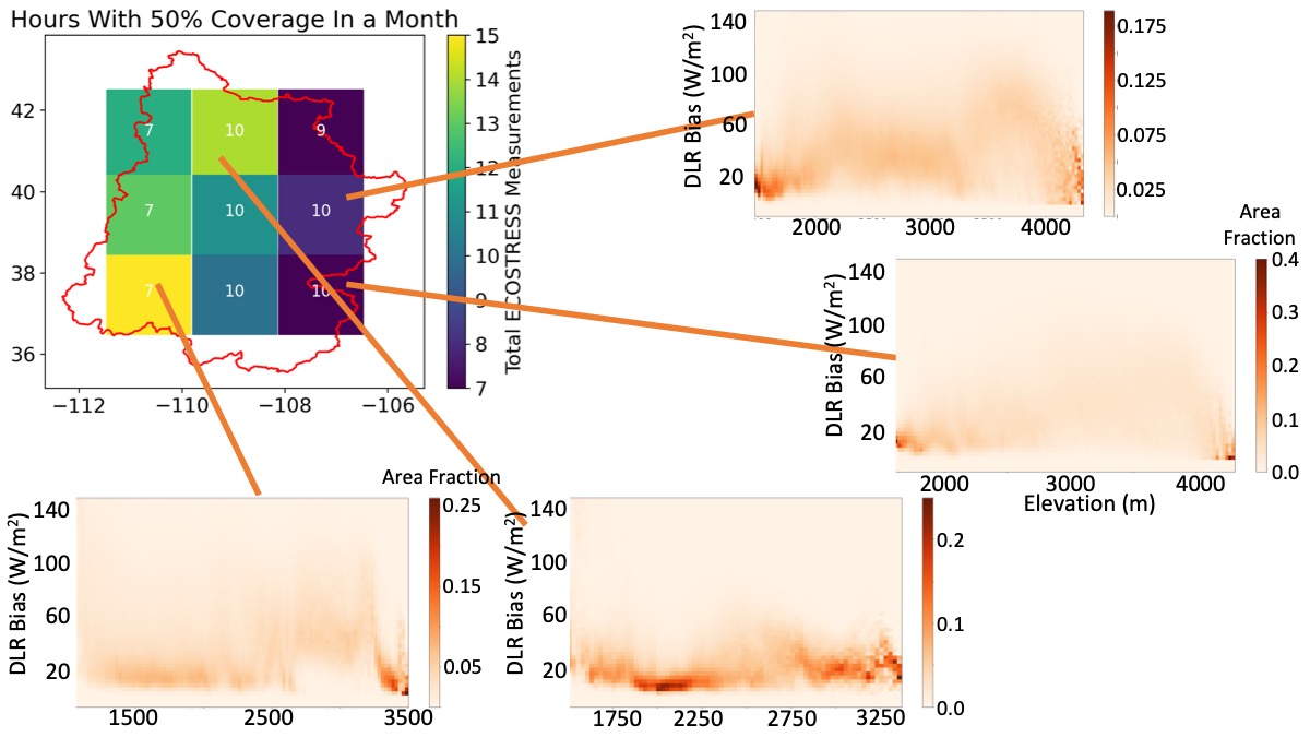
Figure 2. Elevation-resolved histogram downwelling longwave radiation (DLR) bias from neglecting 3D longwave topographic effects. Calculations derived from ECOSTRESS across the Upper Colorado River Basin (UCRB) from 4/20 to 6/20. The center depicts the UCRB with the number in each sub-region indicating the maximum local solar hour time between ECOSTRESS observations, while the color of the sub-region indicates how many ECOSTRESS observations are acquired for that sub-region. From journal.
In the mountains, snow-free surfaces warm much faster during the day than snow-covered ones, and the thermal energy from snow-free surfaces will also warm snow-covered surfaces, thereby melting snow faster in the mountains than in the flatlands. We use high-resolution surface temperature observations from the thermal camera on NASA ECOSTRESS over the entire Upper Colorado River Basin to explore this three-dimensional thermal energy effect and find that it is largest, and likely measurable, at the U.S. Department of Energy (DOE) Atmospheric Radiation Measurement (ARM) user facility's SAIL field campaign study area.
Impact
This work quantifies the importance of three-dimensional thermal energy effects on driving surface temperature, energy, and water budgets in mountains. This effect is simply not included in most process and Earth system models, even though it should be so that models do not underestimate how much terrain contributes to surface warming.
Summary
The complex terrain of mountains impinges on sky-view, and so the surface radiative energy budget is influenced by the terrain. Here, we quantify surface three-dimensional longwave radiative effects from terrain with high-resolution ECOSTRESS surface temperature observations over the Upper Colorado River Basin. We find that the terrain-subtended sky-view represents ~22% of the surface downwelling longwave radiation over this basin and is largest at the eastern edge of the basin where the DOE ARM SAIL campaign is deployed. We estimate that process and Earth system models that do not include three-dimensional longwave radiative effects necessarily underestimate downwelling longwave radiation from ignoring warmer adjacent surfaces and that this bias is ~30 W/m2 during springtime. We also suggest that models can rectify this omission by developing a location-specific parameterization, informed by local observations of downwelling longwave radiation, to ensure that they represent, even simplistically, this radiative process.
Follow Us:


Keep up with the Atmospheric Observer
Updates on ARM news, events, and opportunities delivered to your inbox
ARM User Profile
ARM welcomes users from all institutions and nations. A free ARM user account is needed to access ARM data.


