

Detailed Experiment Description
 In the tropics, cirrus generated by powerful convective storms cover very large areas. These clouds have a large impact on climate by reflecting incoming solar energy and by absorbing infrared energy emitted by the earth’s surface and by the atmosphere. While the importance of cirrus is well known, the detailed composition of these high altitude clouds is not known so the study of tropical cirrus remains an area of very active research and is one of the main themes of research associated with the tropical western Pacific ARM sites located in Manus (Papua New Guinea), Nauru, and Darwin (Australia). Understanding of tropical clouds, gained from the tropical ARM measurements will ultimately be important for improving the representation of these clouds in climate and weather models. Uncertainty in how these clouds are currently represented in models is a significant source of uncertainty in model predictions.
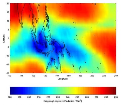
Outgoing Longwave Radiation (OLR) is the measure of infrared radiation emitted to space by the earth. Low values of OLR correspond to emission from regions in the atmosphere with low temperatures. In the tropics, low temperatures are found high in the troposphere and low values of OLR are associated with emission from high cirrus clouds or deep convection cells. The above figure depicts the average distribution of OLR for the month of January. During this time of year, low values of OLR (blue regions) are found through much of the Maritime Continent region and extend south into Northern Australia including the Darwin region. (Data are taken from NOAA/NCEP analyses).
ARM sites include instruments that are designed to observe cloud properties. The two key instruments for retrieving cloud properties are the millimeter cloud radar and the micropulse lidar. Each of these instruments emits pulses of electromagnetic energy, pulses of microwave energy in the case of the radar and visible light in the case of the lidar. These pulses are reflected back to the instrument by particles in the atmosphere. By studying the details of the reflected signals from the radar and the lidar, in conjunction with other ARM instruments, it is possible to obtain some information about the composition of a cloud over the site. However, the process of deriving cloud information from the measurements generally requires making some assumptions about the cloud composition. To improve the quality of the products derived from the radar and lidar it is extremely useful to have additional information about the content of the cloud which can then be used to improve the assumptions that are built into the radar and lidar cloud retrievals.
During TWP-ICE, five aircraft will be flying missions over the ARM site. Two of these aircraft, the Proteus and the Egrett, will carry instruments that measure the size and shape of cirrus ice particles. The Proteus is operated by the DOE while the Egrett and the Dornier (see below) are operated by the United Kingdom ACTIVE (Aerosol and Chemical Transport in tropical convection) program. The remaining two aircraft (also see below) are jointly operated by various institutions and programs. The measurements from the Proteus and Egrett will provide detailed information about the composition of these high altitude clouds. Missions will be flown to characterize ice particle size, shape, and concentration and how they depend on environmental parameters such as altitude and distance from the storm core. A third aircraft, a Twin Otter, will fly far below the Proteus and Egrett and will carry two upward-looking remote sensors, a cloud radar and a cloud lidar. By flying these remote sensors below the high altitude, in-cloud aircraft, the amount of coincident in-cloud and remotely sensed cloud data will be greatly increased versus relying solely on overpasses of the ARM site.
Follow Us:


Keep up with the Atmospheric Observer
Updates on ARM news, events, and opportunities delivered to your inbox
ARM User Profile
ARM welcomes users from all institutions and nations. A free ARM user account is needed to access ARM data.


