

XDS: NWSUPA
NWSUPA: National Weather Service Upper Air Measurements
General Data Description
These data are National Weather Service (NWS) atmospheric soundings for sites within the SGP area (Norman, OK, Topeka, KS, and Dodge City, KS), the NSA (Barrow, AK), and historical data for the Tropical Western Pacific site and Fairbanks, AK. The data are high-vertical-resolution (6 seconds and 1 second) soundings. The ongoing sounding datasets are provided by the National Center for Atmospheric Research (NCAR), with added quality control of the data. The ARM External Data Center (XDC) provides the quality controlled data in netCDF format and the raw ASCII data in monthly files to the ARM Data Center.
Measurement Description
Current NWSUPA Data
Each file contains one sounding in netCDF format.
nwsupa1s: National Weather Service (NWS) upper air 1 sec soundings
nwsupa6s: National Weather Service (NWS) upper air 6 sec soundings
- Pressure (hPa)
- Relative Humidity, at altitude (%)
- Temperature, air, at altitude (deg C)
- Temperature, dewpoint, at altitude (deg C)
- Wind direction, at altitude (degrees)
- Wind speed, S-to-N component, at altitude (m/s)
- Wind speed, W-to-E component, at altitude (m/s)
- Wind speed, at altitude (m/s)
 Quality Code  Information:
0 = Checked, datum seems physically reasonable.  (GOOD)
2 = Checked, datum seems questionable on physical basis. (MAYBE)
3 = Checked, datum seems to be in error.  (BAD)
-1 = Checked, datum is interpolated.  (ESTIMATED)
 9 = Checked, datum was missing in original file.  (MISSING)
-2 = Unchecked (QC information is missing.)  (UNCHECKED)
Missing Data Values:  -9999
Historical NWSUPA Data
In addition, we have historical sounding data in ASCII format and BUFR format. They contain soundings for a given month.
{nsa,sgp,twp}06snwsupa{station}.00
Six-second, high-vertical-resolution upper air soundings for individual stations in or around the NSA (Fairbanks), SGP (Albuquerque) and TWP ARM site locations in ASCII format. See the Spatial Coverage section for location information.
- Pressure (hPa)
- Relative Humidity, at altitude (%)
- Temperature, air, at altitude (deg C)
- Temperature, dewpoint, at altitude (deg C)
- Wind direction, at altitude (degrees)
- Wind speed, S-to-N component, at altitude (m/s)
- Wind speed, W-to-E component, at altitude (m/s)
- Wind speed, at altitude (m/s)
Quality Code (Qc) Information:

0 = Unchecked Datum; QC information is missing.
1 = Checked, datum seems physically reasonable. No physical reason observed to question datum.
2 = Checked, datum seems questionable on a physical basis. The user should      exercise caution when using data with this flag.
3 = Checked, datum appears to be in error. The user is strongly encouraged not to use data with this flag.
8 = Checked (Wind data only), wind datum was computed or interpolated from bad  or outlier original position data. A least-squares fit was applied to a running 2-min.

Missing Data Values:  -999
sgp06snwsupaX1.00
Six second high resolution upper air soundings for the Verification of the Origins of Rotation in Tornadoes EXperiment (VORTEX) These daily data are in columnar ASCII format. The soundings were typically released at 00 and 12 UTC, however, several stations had additional launches on an as requested basis, particularly Norman OK (OUN).
- Time (accumulated seconds)
- Pressure (Pa)
- Altitude (m)
- Temperature (K)
- Dewpoint (K)
- Wind Speed (m/s)
- Wind Direction (deg)
- Longitude (degrees.minutes)
- Latitude (degrees.minutes)
Quality Code information same as above.
Mandatory and Significant Sounding Levels Only
sgpnwsupaX1.00
These monthly data contain soundings at mandatory and significant levels in BUFR format.
twpwmoupaX1.00
ASCII files in spreadsheet format. See sample sounding under “Example Data” below. These data were obtained from NCAR and are World Meteorological Organization (WMO) soundings at mandatory and significant levels.
- Latitude and longitude of station (degrees)
- Station elevation (meters)
- Pressure (millibars)
- Geopotential height (meters)
- Temperature (degrees C)
- Dewpoint depression (degrees C)
- Wind direction (degrees)
- Wind speed (knots)
- Quality marks for geopotential height, temperature, dewpoint depression and wind
Temporal Coverage
Current NWSUPA Data
nsanwsupa1sX10.b1(formerly known as nsa01snwsupabrwX1.b1)    August 2012 - present*
sgpnwsupa1sX11.b1 (formerly known as sgp01snwsupaounX1.b1)    November 2006 - present*
sgpnwsupa1sX12.b1 (formerly known as spg01snwsupatopX1.b1)    April 1, 2009 - present*
sgpnwsupa1sX13.b1 (formerly known as sgp01snwsupaddcX1.b1)    June 22,2010 - present*

Historical NWSUPA Data
nsanwsupa6sX10.b1(formerly known as nsa06snwsupabrwX1.b1)    April 1996 - May 2012
sgpnwsupa6sX13.b1 (formerly known as sgp06snwsupaddcX1.b1)    April 1996 - June 11, 2010
sgpnwsupa6sX11.b1 (formerly known as sgp06snwsupaounX1.b1)    April 1996 - October 2006
sgpnwsupa6sX12.b1 (formerly known as spg06snwsupatopX1.b1)    April 1996 - March 31,2009
nsa06snwsupafaiX1.00    April 1996 - May 2012
sgpnwsupaX1.00          April 1993 - October 1998
sgp06snwsupaX1.00       April 1994 - September 1995
sgp06snwsupaabqX1.00    April 1996 - December 2000
twp06snwsupagumX1.00    April 1996 - December 2000
twp06snwsupahtoX1.00    April 1996 - December 2000
twp06snwsupamkjX1.00    April 1996 - December 2000
twp06snwsupastuX1.00    April 1996 - December 2000
twp06snwsupatkkX1.00    April 1996 - December 2000
twp06snwsupatpnX1.00    April 1996 - December 2000
twp06snwsupatroX1.00    April 1996 - December 2000
twp06snwsupatyaX1.00    April 1996 - December 2000
twp06snwsupawakX1.00    April 1996 - May 1997
twp06snwsupahliX1.00    April 1996 - December 2000
twpwmoupaX1.00          October 1996 - October 1999
* There is about a three month delay in receiving new data.
Area Covered
Current NWSUPA Data
nsanwsupa1sX10.b1(formerly known as nsa01snwsupabrwX1.b1 )- Barrow, Alaska
sgpnwsupa1sX11.b1(formerly known as sgp01snwsupaounX1.b1) – Norman, OK
sgpnwsupa1sX12.b1(formerly known as spg01snwsupatopX1.b1) – Topeka, Kansas
sgpnwsupa1sX13.b1(formerly known as sgp01snwsupaddcX1.b1) – Dodge City, Kansas
Historical NWSUPA Data
nsanwsupa6sX10.b1(formerly known as nsa06snwsupabrwX1.b1 ) – Barrow, Alaska
nsa06snwsupafaiX1.00 – Fairbanks, Alaska
sgp06snwsupaabqX1.00 – Albuquerque, NM
sgpnwsupa6sX11.b1(formerly known as sgp06snwsupaounX1.b1) – Norman, OK
sgpnwsupa6sX12.b1(formerly known as spg06snwsupatopX1.b1) – Topeka, Kansas
sgpnwsupa6sX13.b1(formerly known as sgp06snwsupaddcX1.b1) – Dodge City, Kansas
sgp06snwsupaX1.00
Twelve NWS sounding stations in the VORTEX domain (lat 31N : 40N lon 91W: 107W).
Lat     Lon             Station Name
----------------------------------------
31.8    -106.4          El Paso, TX
32.0    -102.2          Midland, TX
32.5    -93.8           Shreveport, LA
32.8    -97.8           Ft. Worth, TX
34.8    -92.3           North Little Rock, AR
35.0    -106.6          Albuquerque, NM
35.2    -97.4           Norman, OK
35.2    -101.7          Amarillo, TX
37.2    -93.4           Springfield, MO
37.8    -100            Dodge City, KS
39.1    -95.6           Topeka, KS
39.8    -104.9          Denver, CO
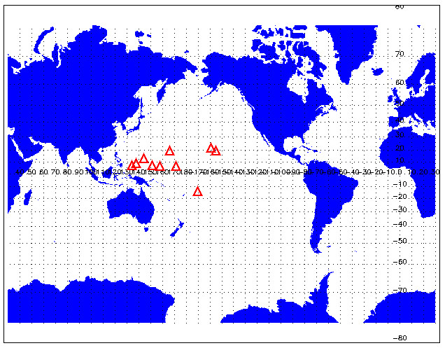
twp06snwsupagumX1.00 – Guam, Marianna Is (144 48.00’E, 13 30.00’N)
twp06snwsupahtoX1.00 – Hilo, HI (155 06.00’W, 19 42.00’N)
twp06snwsupamkjX1.00 – Majuro, Marshall Is (171 24.00’E, 7 06.00’N)
twp06snwsupastuX1.00 – Pago Pago, Am Samoa (170 42.00’W, 14 18.00’S)
twp06snwsupatkkX1.00 – Moen Is, Micro. (151 48.00’E, 7 24.00′)
twp06snwsupatpnX1.00 – Ponape, ECI (158 12.00’E, 7 00.00’N)
twp06snwsupatroX1.00 – Koror, Palau Is, Micro. (134 30.00’E, 7 18.00’N)
twp06snwsupatyaX1.00 – Yap, WCI (138 06.00’E, 9 30.00’N)
twp06snwsupawakX1.00 – Wake Island (166 39.00’E, 19 17.00’N)
twp06snwsupahliX1.00 – Lihue, HI (159 24.00’W, 22 00.00’N)
Historical Mandatory and Significant Level Data
sgpnwsupaX1.00 – Covers the entire Continental United States
twpwmoupaX1.00 – TWP WMO station listings
Datastream Inputs
nsanwsupa1sX10.00(formerly known as nsa01snwsupabrwX1.00 )
sgpnwsupa1sX11.00(formerly known as sgp01snwsupaounX1.00)
sgpnwsupa1sX12.00(formerly known as sgp01snwsupatopX1.00)
sgpnwsupa1sX13.00(formerly known as sgp01nwsupaddcX1.00)
Related Links
Contacts
ARM Data Center
Data Source
Institution
National Center for Atmospheric Research
Data User Notes
On November 13, 2006 the Norman, OK changed over to the Radiosonde Replacement System (RRS). The other three stations followed and by 2012 all stations were using the RRS with a vertical resolution of 1 second. Previously the vertical resolution was 6 seconds. With the change to RRS there were some changes in the instrumentation and data processing:
- The winds are determined from a GPS.
- The data are now at 1-second vertical resolution.
- There is some additional information added to the header records.
- The smoothed and processed version of the data have been used. Corrections, such as the solar radiation correction, have been applied.
Additional Information
- The GPS data are smoothed to remove the erratic and pendular motion of the sonde.
- The PTH and GPS data are processed by applying normalization, correction, smoothing, outlier removal, and data plausibility checks to the raw PTH and smoothed GPS data.
- The raw wind data are nomalized by linear interpolation into 1-second processed data.
- For pressure the smoothing is performed over 11 seconds of corrected pressure and the result is applied to the 6th pressure element in the 11-second spread. A least squares formula is utilized.
- For temperature the smoothing is performed over 9 seconds of corrected temperature and the result is applied to the 5th temperature element in the 9-second spread. A running mean is utilized.
- Pressure correction is used to compensate for offsets of the sonde pressure sensor compared to the surface pressure sensor.
- Temperature correction is used to compensate for solar radiation.
The following information about sounding differences between NWS Barrow sondes and ARM RS90 sondes was sent by Ed Westwater 2004: Refer to the powerpoint presentation at XDC website.
Slide 1. Shows how our RAOB launches were conducted: At the Great White, the operational procedure was followed, except for the Saturday and Sunday launches. At the ARM Duplex, we launched 4/day of the RS-90 sondes. On 8 separate occasions at the Duplex, we launched the Snow Whites, which contained a Chilled Mirror and a Carbon Hygristor humidity element. On the same balloon the RS90s were also attached. Two-synoptic launches/day were conducted by the NWS at Barrow, using the VIZ Carbon Hygristor sondes. A data set of about 200 radiosondes was obtained during the WVIOP.
Slide2. Shows the dramatic difference between the performance of the carbon hygristor and the RS90. The plot on the right shows a single launch of the 5 sensors. The plot in the upper right shows the significant statistical difference between the NWS and the RS90 that approaches 20% in the upper troposphere-lower stratosphere. The lower left plot shows that there was little, if any, difference between the RS90 and the Chilled Mirror. Bottom line: the Barrow NWS sondes would be of very limited value for long-term climate studies or for satellite validation.
Slide 3. Shows the PWV as measured by all of the RAOB types. Bottom line: the PWV from the NWS sondes is also biased, but the agreement between the Chilled Mirror and the RS90 is excellent.
Example Data
- Six second, high-vertical-resolution soundings by individual station {nsa,sgp,twp}06snwsupa{station}
- Six-second, high-vertical-resolution soundings for 12 stations in SGP area sgp06snwsupaX1.00
- Mandatory and significant level soundings for the TWP twpwmoupaX1.00
Acronyms
ADPUPA    Automatic Data Processing, UPper-Air data file
BUFR      Binary Universal Format for the Representation of meteorological data
CLASS     Cross Chain LORAN Atmospheric Sounding System
JOSS      Joint Office for Science Support
NCAR      National Center for Atmospheric Research
NSA       North Slope of Alaska
NWS       National Weather Service
SGP       Southern Great Plains
TWP       Tropical Western Pacific
UCAR      University Corporation for Atmospheric Research
UPA       Upper Air
VORTEX    Verification of the Origins of Rotation in Tornadoes EXperiment
WMO       World Meteorological Organization
Citable References
Loherer, SM, TA Edmands and JA Moore. 1996. “TOGA COARE Upper-Air Sounding Data Archive: Development and Quality Control Procedures.” Bulletin of the American Meteorological Society 77(11): 2651-2671, doi: 10.1175/1520-0477(1996)077<2651:tcuasd>2.0.co;2
Loehrer, S. M., S. F. Williams, and J. A. Moore, 1998: Results from UCAR/JOSS quality control of atmospheric soundings from field projects. Preprints, Tenth Symposium on Meteorological Observations and Instrumentation, Phoenix, AZ, Amer. Meteor. Soc., 1-6.
NWS, 1991: Micro-ART Observation and Rework Programs Technical Document, National Weather Service, National Oceanic and Atmospheric Administration, Washington, D.C., March 1991.
Wade, C. G., 1995: Calibration and data reduction problems affecting National Weather Service radiosonde humidity measurements. Preprints, Ninth Symposium on Meteorological Observations and Instrumentation, Charlotte, NC, Amer. Meteor. Soc., 37-42.
Williams, S. F., C. G. Wade, and C. Morel, 1993: A comparison of high resolution radiosonde winds: 6-second Micro-ART winds versus 10-second CLASS LORAN winds. Preprints, Eighth Symposium on Meteorological Observations and Instrumentation, Anaheim, California, Amer. Meteor. Soc., 60-65.
Williams, S. F., S. M. Loehrer, and D. R. Gallant, 1998: Computation of high-resolution National Weather Service rawinsonde winds. Preprints, Tenth Symposium on Meteorological Observations and Instrumentation, Phoenix, AZ, Amer. Meteor. Soc., 387-391.
Follow Us:


Keep up with the Atmospheric Observer
Updates on ARM news, events, and opportunities delivered to your inbox
ARM User Profile
ARM welcomes users from all institutions and nations. A free ARM user account is needed to access ARM data.


