

XDS: ECMWF
ECMWF: European Centre for Medium Range Weather Forecasts Model Data
General Data Description
ACRF purchases the gridded operational analysis product from ECMWF Operatational Analysis and Forecasting System covering a large area of the TWP, including all TWP ACRF sites. These files are provided in GRIB format and are converted to netCDF.
These data can only be distributed to ARM scientists. ARM scientists who obtain these data must agree to acknowledge use of the data in their publications and not to share the data with others who are not on the ARM Science Team.
Derived data are defined as data from which the ECMWF fields cannot be re-created.
Such data can be freely distributed by ARM scientists.
The distribution of raw ECMWF fields to third parties is not allowed without the explicit permission of ECMWF. This is the general rule for all data supplied by ECMWF.
Permission can be requested to supply data to groups outside ARM for specific projects. In such cases, if permission was given, a conditions form would be produced by ECMWF to be signed by the principal investigator of such a group.
Measurement Description
twpecmwf[xxx]suppX1.c1
All the fields except for the cloud cover contain values that have been accumulated over 6 hours since the start of the forecast.
- Surface sensible heat flux ((W/m^2)*s)
- Surface latent heat flux ((W/m^2)*s)
- Surface solar radiation ((W/m^2)*s)
- Surface thermal radiation ((W/m^2)*s)
- Top solar radiation ((W/m^2)*s)
- Top thermal radiation ((W/m^2)*s)
- East/West surface stress ((N/m^2)*s)
- North/South surface stress ((N/m^2)*s)
- Total cloud cover (0-1)
Beginning with the October 1999 files, the following two measurements have been added:
- Surface solar radiation downward ((W/m^2)*s)
- Surface thermal radiation downward ((W/m^2)*s)
Beginning with the January 2006 files, the following two measurements have been added:
- Convective precipitation (m)
- Large scale precipitation (m)
twpecmwf[xxx]surfX1.c1
Surface fields:
- Surface pressure (Pa)
- U,v at 10 m (m/s)
- Temperature at 2m (K)
- Dew point at 2 m (K)
- Snow depth (m (water))*
- MSL pressure (Pa)
- Orography (m^2/s^2)
- Land-sea mask (0,1)
- Surface roughness (m)
- Albedo
Sub-surface fields:
- Soil temperature (K)/soil wetness (m (water))
- *0.0 – 0.07 m (level 1)
- **0.07 – 0.28 m (level 2)
- **0.28 – 1.0 m (level 3)
- **1.0 – 2.89 m (level 4)
The following measurements were added beginning with the October 1999 files:
- Total column water (kg/m^2)
- Skin temperature (K)
*These measurements are no longer present beginning in October 1999.
**Beginning on 2000-06-27, ECMWF issued a new model cycle (22r3) in which soil wetness level 1 is replaced by volumetric soil water layer 1 (m^3/m^3).
The follow measurements were added beginning in October 2000:
- Sea surface temperature (K)
- Low cloud cover (0-1)
- Medium cloud cover (0-1)
- High cloud cover (0-1)
Note: surface pressure is the pressure on the model orography and should be used in conjunction with the surface geopotential.
twpecmwf[xxx]upaX1.c1
The “Upper Air” measurements are all given at the 15 model levels: 1000, 925, 850, 700, 500, 400, 300, 250, 200, 150, 100, 70, 50, 30, 10 hPa.
- Geopotential (m^2/s^2)
- Temperature (K)
- Vertical Velocity (Pa/s)
- U-velocity (m/s)
- V-velocity (m/s)
- Relative Humidity (%)
Temporal Coverage
Data are available beginning in October 1996. The GRIB files are delivered to the XDC with an approximately one-month delay.
Area Covered
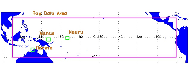
The area covered for the TWP GRIB model output is Latitude: 20° N to -20° S, Longitude: 110° E to 280° E.
Data Stream Inputs
The native GRIB format files from the ECMWF are archived as:
twpecmwfsuppX1.00
twpecmwfsurfX1.00
twpecmwfupaX1.00
Related Links
ECMWF Web Site
ECMWF Model Revision History
ECMWF Operational Upgrades
Contacts
ARM Data Center
Data Source
Institution
ECMWF Data Services
Data User Notes
Acknowledgments
Publications should refer to: “The ECMWF operational analysis and forecasting system: The full evolution http://www.ecmwf.int/products/data/operational_system/index.html”
twpecmwf[xxx]suppX1.c1
ECMWF introduced a major operational archive change on 2000-09-12 that affects first-guess data. Supplementary fields’ data are extracted from first-guess fields and are thus affected. ECMWF has changed the data assimilation period in the 4-D variational analysis data assimilation system from 6 to 12 hours. Analyses are still produced every 6 hours as previously.
Previously, the first-guess data consisted of 6-hour forecasts from the times 00, 06, 12, and 18 UTC. Under the new 12-hour assimilation cycle, this is replaced by 12-hour forecasts from the times 00 and 12 UTC. Thus data from base time 6 at forecast step 6 under the previous system are replaced by data from base time 00 at forecast step 12 under the new scheme. All data that had a base time of 06 or 18 UTC under the old scheme have a similar change.
Reading GRIB Formatted Files
Information on reading GRIB formatted files can be found at: Reading netCDF, HDF, and GRIB Files
Acronyms
DAR     Darwin, Australia
ECMWF   European Centre for Medium Range Forecasting
FKB     Black Forest, Germany
GRIB    GRIdded Binary
MAN     Manus, Papua New Guinea
NAU     Nauru, Republic of Nauru
NIM     Niamey, Niger, Africa
NSA     North Slope of Alaska
PYE     Point Reyes, California
SGP     Southern Great Plains
TWP     Tropical Western Pacific
Citable References
“The ECMWF operational analysis and forecasting system: The full evolution http://www.ecmwf.int/products/data/operational_system/index.html”
Follow Us:


Keep up with the Atmospheric Observer
Updates on ARM news, events, and opportunities delivered to your inbox
ARM User Profile
ARM welcomes users from all institutions and nations. A free ARM user account is needed to access ARM data.


